Green Infrastructure in Urban Planning: Strategies, Benefits, and Evidence-Based Implementation for Sustainable Cities
This comprehensive review examines green infrastructure's multifaceted role in contemporary urban planning, addressing the needs of researchers, scientists, and development professionals.
Green Infrastructure in Urban Planning: Strategies, Benefits, and Evidence-Based Implementation for Sustainable Cities
Abstract
This comprehensive review examines green infrastructure's multifaceted role in contemporary urban planning, addressing the needs of researchers, scientists, and development professionals. The article explores foundational ecological principles and the environmental, social, and economic benefits of nature-based solutions. It details methodological approaches for implementation across scales, from building-level innovations to city-wide systems, supported by global case studies. The analysis identifies technical, financial, and governance barriers alongside optimization strategies, and validates effectiveness through comparative performance metrics and documented outcomes. This synthesis provides evidence-based guidance for integrating green infrastructure into urban development frameworks to enhance climate resilience, public health, and sustainable growth.
Understanding Green Infrastructure: Core Concepts, Ecosystem Services, and Urban Resilience Benefits
The conceptualization of Green Infrastructure (GI) has undergone a significant evolution in urban planning research, shifting from a narrow focus on individual green features to a comprehensive understanding of interconnected ecological networks [1]. This paradigm transformation reflects the growing recognition that sustainable urban development requires a systemic approach to ecological planning, where multifunctionality and connectivity become central design principles [2]. Where traditional approaches treated parks, green spaces, and water bodies as isolated amenities, the contemporary GI framework reimagines them as integrated systems that provide essential ecosystem services while enhancing community resilience [2]. This conceptual paper outlines this critical evolution and provides application notes and protocols for researchers and practitioners engaged in urban ecological research.
The development of GI theory mirrors broader trends in sustainability science, particularly the integration of ecological principles with urban infrastructure planning. This interdisciplinary approach acknowledges that the challenges of rapid urbanization, climate change, and biodiversity loss cannot be addressed through traditional grey infrastructure alone [3]. The modern GI framework represents a sophisticated understanding of urban ecosystems as complex socio-ecological systems where environmental, social, and economic benefits are synergistically generated through strategically planned and managed natural systems [1] [2].
Theoretical Framework: From Discrete Features to Networked Systems
The Evolution of GI Conceptualization
The theoretical underpinnings of GI have progressed through distinct phases of conceptual refinement, as illustrated in Table 1, which summarizes key developmental stages.
Table 1: Evolutionary Stages of Green Infrastructure Conceptualization
| Stage | Primary Focus | Scale of Intervention | Key Characteristics | Planning Approach |
|---|---|---|---|---|
| Feature-Based GI | Individual green elements | Site-specific | Isolated parks, rain gardens, green roofs | Single-objective, reactive planning |
| Multifunctional GI | Multiple ecosystem services | Neighborhood level | Designed for combined benefits (e.g., stormwater management + recreation) | Multi-objective, integrated design |
| Networked GI | Ecological connectivity | City to regional scale | Interconnected systems of green and blue spaces | Strategic, proactive planning |
| Socio-Ecological GI | Social-ecological systems | Cross-scale interactions | Integration of ecological and social dimensions | Transdisciplinary, co-design approach [1] |
This evolution represents a fundamental shift from viewing GI as a collection of discrete elements to understanding it as a strategically planned network that is "the interconnected web of natural and semi-natural areas designed to deliver a wide range of ecosystem services" [2]. The networked perspective emphasizes functional connectivity over mere physical proximity, requiring sophisticated planning approaches that consider ecological flows, species movement, and the spatial configuration of landscape elements [1].
Defining Characteristics of Modern Green Infrastructure
Contemporary GI theory is characterized by several core principles that distinguish it from earlier conceptions:
- Multifunctionality: The capacity to deliver multiple ecological, social, and economic benefits simultaneously, such as stormwater management, urban cooling, recreational space, and habitat provision [2].
- Connectivity: Strategic interconnection of natural areas through green corridors to facilitate ecological processes and species movement [2].
- Scalability: Applicability across multiple spatial scales, from individual sites to regional landscapes [2].
- Integration with Grey Infrastructure: Designed to complement and enhance conventional infrastructure systems rather than replace them [3].
- Adaptive Capacity: Ability to adjust to changing environmental conditions and disturbance events, enhancing urban resilience [3].
Research Methodologies and Assessment Protocols
GIS-Based Assessment Framework
Geographic Information Systems (GIS) have emerged as essential tools for assessing, planning, and optimizing GI networks. Recent methodological advances have enabled more comprehensive evaluations that integrate multiple data sources and analytical approaches, as detailed in Table 2.
Table 2: GIS Data Sources and Analytical Methods for GI Assessment
| Assessment Dimension | Primary Data Sources | Key Analytical Methods | Output Metrics |
|---|---|---|---|
| Accessibility | Remote sensing imagery, Census data, Transportation networks | Network analysis, Buffer analysis, Gravity models | Distance to nearest green space, Service area coverage, Population served |
| Ecosystem Service Potential | Land cover maps, Soil data, Digital elevation models | Multi-criteria decision analysis, Habitat suitability modeling, Hydrological modeling | Carbon sequestration potential, Stormwater retention capacity, Habitat quality indices |
| Resilience Indicators | Climate projections, Land use maps, Infrastructure data | Vulnerability indexing, Scenario planning, Overlay analysis | Flood risk reduction, Heat island mitigation capacity, Connectivity indices |
| Social Equity | Demographic data, Land value records, Health statistics | Spatial regression, Lorenz curves, Location quotient analysis | Distribution of benefits across socioeconomic groups, Environmental justice indicators |
The integration of diverse data streams through GIS platforms allows researchers to move beyond singular assessments to develop holistic understandings of GI performance [4]. Modern approaches increasingly incorporate artificial intelligence (AI) algorithms to process large datasets and identify patterns not readily apparent through conventional analysis [4]. However, even with these technological advances, field research remains crucial for validating GIS findings and ensuring alignment with community experiences and needs [4].
Experimental Protocol: GIS-Based GI Network Assessment
Protocol Objective: To systematically identify, evaluate, and prioritize potential areas for GI implementation within an urban context using geospatial analysis.
Phase 1: Data Collection and Preparation
- Step 1: Compile spatial datasets including land use/cover classifications, digital elevation models, soil characteristics, hydrologic features, and impervious surface maps.
- Step 2: Collect socio-demographic data at appropriate census geographies and infrastructure inventories.
- Step 3: Acquire remote sensing imagery (e.g., satellite, aerial photography) for vegetation indices and change detection analysis.
- Step 4: Establish coordinate reference system and spatial resolution for all datasets; conduct data cleaning and standardization.
Phase 2: Multi-Criteria Analysis
- Step 5: Identify assessment criteria through stakeholder engagement (including community representatives) and literature review [1] [5].
- Step 6: Develop standardized scoring systems for each criterion (e.g., 1-5 scale representing low to high priority).
- Step 7: Apply spatial analysis techniques to generate criterion maps: - Stormwater management need: Combine impervious surface coverage, flood risk areas, and soil drainage capacity - Heat mitigation priority: Analyze land surface temperature data with population density and vulnerability indicators - Ecological connectivity: Model habitat patches and potential corridors using least-cost path analysis - Social equity: Identify areas with high population density but low green space access
- Step 8: Implement weighted overlay analysis based on stakeholder-derived priority weights.
Phase 3: Validation and Refinement
- Step 9: Conduct field verification of high-priority sites to validate GIS findings and assess site-specific conditions.
- Step 10: Refine priority maps based on field observations and local knowledge.
- Step 11: Engage decision-makers and community representatives in review of preliminary results.
- Step 12: Finalize GI network plan with implementation phasing and management recommendations.
This protocol emphasizes the importance of transdisciplinary collaboration throughout the assessment process, integrating technical analysis with community knowledge and policy considerations [1]. The workflow for this assessment methodology is visualized in Figure 1.
Figure 1: Workflow for GIS-based Green Infrastructure Assessment Methodology
Research Reagent Solutions
Table 3: Essential Research Tools and Data Sources for GI Investigation
| Tool Category | Specific Examples | Primary Research Application | Data Output/Function |
|---|---|---|---|
| Remote Sensing Platforms | Sentinel-2, Landsat 9, LiDAR, UAV/drone imagery | Vegetation monitoring, 3D structure analysis, change detection | NDVI, land cover classification, canopy height models, change maps |
| GIS Software | ArcGIS, QGIS, GRASS GIS | Spatial analysis, data integration, visualization | Suitability maps, network connectivity, service area delineation |
| Environmental Models | i-Tree, SUSTAIN, InVEST | Ecosystem service quantification, scenario testing | Stormwater runoff, carbon storage, air pollution removal |
| Social Survey Tools | Structured questionnaires, PPGIS, focus group protocols | Community needs assessment, preference mapping, governance analysis | Usage patterns, perceived benefits, priority areas, co-design input |
| Field Measurement Equipment | Soil moisture sensors, water quality test kits, sound meters | Performance validation, microclimate assessment, ecological monitoring | Infiltration rates, pollutant loads, temperature moderation |
Analytical Framework for Stakeholder Collaboration
Successful GI implementation requires effective collaboration across multiple stakeholder groups. Research indicates that progressing through increasing levels of integration leads to more sustainable outcomes, as visualized in Figure 2.
Figure 2: Stakeholder Collaboration Progression for GI Planning [1]
Application Notes: Implementing GI Networks in Urban Contexts
Design Strategies for Constrained Environments
Implementing GI in existing urban areas presents unique challenges that require tailored design strategies. Based on EPA guidelines and recent research, the following application notes address common constraints [5]:
- Low Infiltration Sites: For areas with compacted urban soils or clay substrates, specify non-infiltrating systems such as rainwater harvesting, green roofs, and grassed swales with underdrains [5].
- Groundwater Protection: In areas with shallow water tables or potential contamination concerns, employ filtration-based practices rather than infiltration systems, particularly avoiding siting infiltrating GI down-gradient of pollution hot spots [5].
- Arid and Semi-Arid Regions: Select drought-tolerant native vegetation and implement water-sensitive urban design principles that maximize rainwater capture and reuse [5].
- Maintenance Considerations: Design with long-term operability requirements by selecting appropriate vegetation, ensuring equipment access, and planning for resource availability [5].
Performance Metrics and Monitoring Protocol
Rigorous assessment of GI performance requires standardized monitoring approaches. Table 4 outlines key metrics for evaluating GI network effectiveness across multiple benefit categories.
Table 4: Green Infrastructure Performance Assessment Metrics
| Benefit Category | Key Performance Indicators | Measurement Methods | Target Thresholds |
|---|---|---|---|
| Hydrological Regulation | Runoff volume reduction, Peak flow attenuation, Water quality improvement | Continuous monitoring, Composite sampling, Infiltration tests | 80-90% volume reduction for small storms, 40-60% TSS removal |
| Thermal Regulation | Surface temperature reduction, Air temperature moderation | Thermal imaging, Fixed weather stations, Mobile transects | 1-3°C air temperature reduction, 10-15°C surface temperature reduction |
| Ecological Performance | Native plant establishment, Pollinator activity, Soil health indicators | Floristic surveys, Insect trapping, Soil testing | >70% native plant cover, Increased soil organic matter |
| Social Benefits | Usage patterns, Perceived safety, Community satisfaction | Behavioral mapping, Structured surveys, Focus groups | >80% user satisfaction, Diverse user demographics |
Implementation Challenges and Mitigation Strategies
Despite the demonstrated benefits, GI implementation faces significant barriers that researchers and practitioners should anticipate:
- Funding Mechanisms: Develop public-private partnerships, explore environmental impact bonds, and quantify lifecycle cost savings compared to grey infrastructure alternatives [2].
- Policy Integration: Advocate for updated zoning codes, stormwater fee credits, and green space requirements in development regulations [6].
- Technical Capacity: Build municipal expertise through training programs, design guidelines, and knowledge-sharing networks [5].
- Equity Considerations: Implement anti-displacement strategies alongside GI investments to prevent green gentrification and ensure equitable distribution of benefits [2].
The evolution of green infrastructure from single features to interconnected networks represents a paradigm shift in urban planning and ecological design. This transformation acknowledges that the complex challenges facing contemporary cities require integrated solutions that bridge ecological and social systems. The frameworks, protocols, and tools outlined in this document provide researchers and practitioners with methodologies for advancing this field through rigorous, transdisciplinary approaches.
Future research directions should focus on enhancing predictive modeling capabilities, refining equity assessment frameworks, and developing innovative financing mechanisms that recognize the full value of ecosystem services provided by GI networks. Additionally, as climate change intensifies, research on the adaptive capacity of different GI configurations will be critical for building urban resilience. By embracing the networked conceptualization of GI and employing the comprehensive assessment methodologies described here, researchers can contribute to the development of more sustainable, livable, and resilient urban environments.
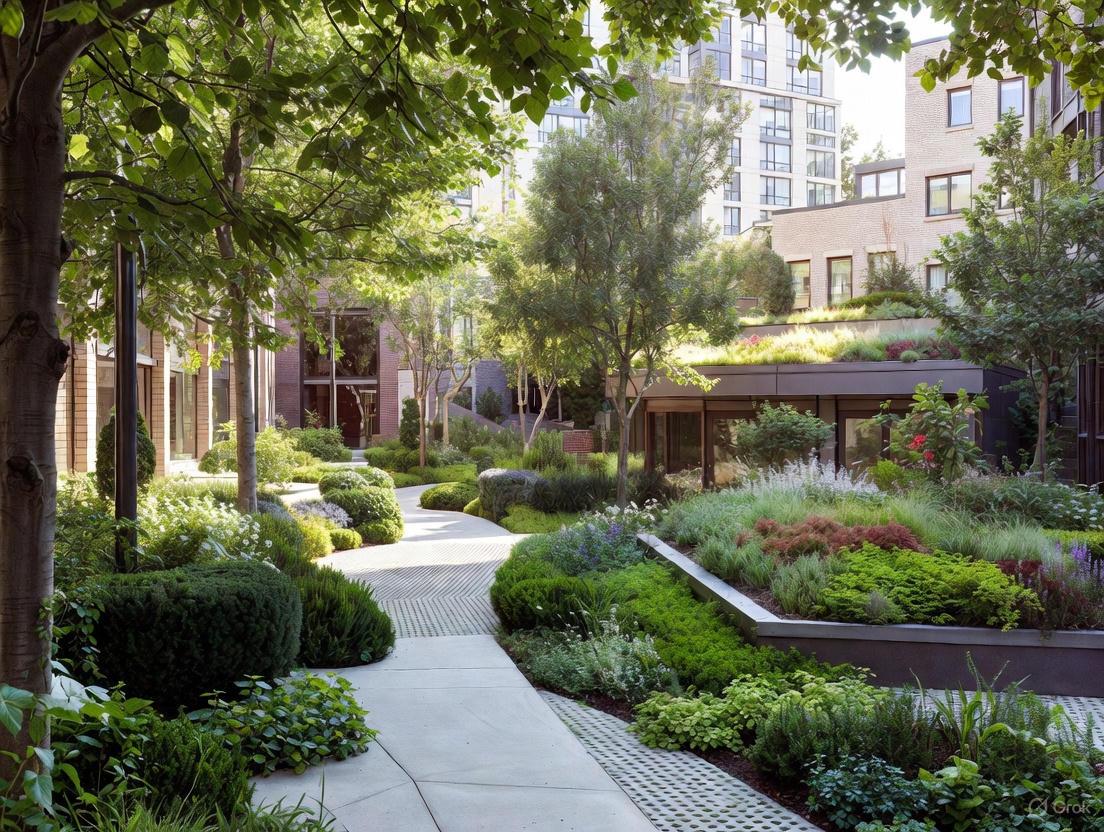
Application Notes and Protocols for Green Infrastructure in Urban Planning
Rain Gardens (Bioretention Systems)
Application Notes Rain gardens are shallow, landscaped depressions designed to capture, store, and infiltrate stormwater runoff from impervious urban surfaces such as roofs, driveways, and streets. They function as a best management practice (BMP) within the broader context of Low-Impact Development (LID) and Sustainable Urban Drainage Systems (SUDS), leveraging natural processes of bioretention to improve water quality and manage quantity. Key environmental benefits include significant reduction in stormwater runoff volume (approximately 30% more water infiltration compared to conventional lawns), groundwater recharge, and pollution mitigation through the filtration of contaminants like fertilizers, pesticides, animal waste, and heavy metals [7] [8]. They also provide habitat for native species and enhance urban biodiversity.
Table 1: Performance Metrics and Design Specifications for Rain Gardens
| Parameter | Target Performance/Design Specification | Notes and Variability |
|---|---|---|
| Runoff Reduction | ~30% more infiltration than conventional lawn [7] | Contributes to groundwater recharge. |
| Water Quality Improvement | Filters pollutants (fertilizers, pesticides, oils, bacteria) [7] | Achieved via bioretention. |
| Design Depth | 4 to 8 inches deep [7] | Must be level; depth depends on soil type. |
| Drainage Time | Within 1 hour after a storm event [7] | Prevents mosquito breeding. |
| Soil Infiltration Rate | Sandy (fastest) > Silty > Clayey (slowest) [7] | Clay soils require more surface area. |
| Setback Distance | Minimum 10 feet from building foundations [7] [9] | Protects structural integrity. |
Experimental Protocol: Site Assessment, Construction, and Monitoring
- Objective: To establish a functional rain garden for stormwater capture, infiltration, and pollutant removal.
- Materials: See "The Scientist's Toolkit" below.
- Site Selection Procedure:
- Identify Drainage Patterns: Observe water flow during a rain event to locate natural depressions or areas receiving runoff from downspouts or streets [7].
- Soil Infiltration Test: Perform a percolation test to determine soil type and infiltration rate. Sandy and silty soils are preferred; avoid areas with high clay content or high water tables that drain poorly [7].
- Utility Location: Before digging, contact the national "Call Before You Dig" service (phone 811) to mark underground utilities [7].
- Avoid Unsuitable Areas: Exclude sites within 10 feet of building foundations, areas with large tree roots, septic systems, or constantly saturated ground [7].
Construction and Planting Procedure:
- Excavation: Excavate the area to the planned depth (4-8 inches), ensuring the base is level [7].
- Soil Amending: Amend native soil with organic compost to enhance water holding capacity and microbial activity [7].
- Inlet and Overflow Creation: Form an inlet channel (swale) from the water source (e.g., downspout) with a 2% slope (1/4 inch per foot). Create an overflow outlet, such as a pipe or a notch in the berm, to safely manage water from extreme rainfall events [7] [9].
- Planting Strategy: Plant a diversity of native, climate-adapted species. Group plants in clusters of 3-7. Place water-tolerant species (e.g., Deer grass, Douglas iris) in the garden base, moderately tolerant species (e.g., Common rush) on the mid-slope, and drought-tolerant species (e.g., Russian sage, succulents) on the upper berm [7].
Monitoring and Maintenance Protocol:
- Post-Storm Observation: After rainfall, verify water is flowing into and infiltrating within the garden as designed [7].
- Routine Maintenance: Periodically remove debris, sediment buildup, and weeds. Apply a layer of coarse wood chip mulch to suppress weeds and retain moisture [7].
- Watering: Irrigate plants during establishment and periods of dry weather [7].
- Soil Aeration: Aerate the soil surface if it becomes compacted or clogged with fine sediments [7].
Green Roofs (Rooftop Gardens)
Application Notes Green roofs are engineered systems involving a vegetative layer grown on a building rooftop. They are a critical nature-based solution for mitigating the urban heat island (UHI) effect, managing stormwater, and improving energy efficiency. They are categorized as extensive (shallow, lightweight, low-maintenance) or intensive (deeper, park-like, higher maintenance) [10]. Proven benefits include reducing roof surface temperatures by up to 56°F and nearby air temperatures by up to 20°F, lowering building cooling load by up to 70%, and reducing indoor air temperature by up to 27°F [10] [11]. They also sequester carbon, mitigate air pollutants, and provide habitat.
Table 2: Performance Metrics and Design Specifications for Green Roofs
| Parameter | Extensive Green Roof | Intensive Green Roof |
|---|---|---|
| Growing Medium Depth | 2 to 4 inches [10] | > 6 inches, can support trees [10] |
| Structural Load | Low [10] | High, requires added support [10] |
| Maintenance Needs | Low [10] | High [10] |
| Surface Temp. Reduction | Up to 56°F lower than conventional roof [10] | Similar or greater, depending on design [10] |
| Runoff Reduction | Up to 60% [10] | Up to 100% [10] |
| Cooling Load Reduction | Contributes to reductions up to 70% [11] | Contributes to reductions up to 70% [11] |
Experimental Protocol: Design, Installation, and Performance Monitoring
- Objective: To install a green roof system for thermal regulation, stormwater retention, and energy savings.
- Materials: See "The Scientist's Toolkit" below.
- Pre-Installation Assessment Procedure:
- Structural Analysis: Engage a structural engineer to assess the load-bearing capacity of the roof and determine the suitable type (extensive vs. intensive) [10].
- Waterproofing and Root Barrier Inspection: Ensure the base roof membrane is intact and install a root-resistant barrier to protect the structure [10].
Installation Procedure:
- Layer Installation: Install the following layers in sequence from the roof deck upward: protection layer, waterproofing membrane, root barrier, drainage layer (with water reservoirs), filter fabric, growing medium (engineered soil), and vegetative layer [10].
- Plant Selection: For extensive roofs, use hardy, drought-tolerant, shallow-rooted succulents like Sedum species. Intensive roofs can support a wider variety of grasses, perennials, shrubs, and trees [10].
- Irrigation System: While extensive roofs may not need permanent irrigation after plant establishment, temporary irrigation is often necessary. Intensive roofs typically require an integrated irrigation system [10].
Monitoring and Performance Evaluation Protocol:
- Thermal Monitoring: Use data loggers to measure and compare roof membrane temperatures, indoor air temperatures beneath the roof, and ambient air temperatures above green vs. conventional roofs.
- Hydrological Monitoring: Install flow meters on downspouts to quantify runoff volume and peak flow delay from the green roof compared to a predicted runoff from a conventional roof.
- Energy Monitoring: Analyze building energy consumption data for cooling and heating before and after green roof installation to calculate energy savings.
- Ecological Monitoring: Conduct periodic surveys to monitor plant health, biodiversity, and presence of pollinators.
Permeable Pavements
Application Notes Permeable pavements are alternative paving materials that allow stormwater to infiltrate through the surface into underlying layers of stone and/or soil, reducing surface runoff and filtering pollutants. Common types include pervious concrete, porous asphalt, and interlocking concrete pavers. They are a core component of Water Sensitive Urban Design (WSUD) and are particularly effective in reducing peak runoff flows and mitigating localized flooding [12] [13]. They also contribute to mitigating urban heat islands through evaporative cooling and reducing the need for road salt in winter [12] [13]. A key challenge is clogging, which requires preventative maintenance to sustain performance.
Experimental Protocol: Installation and Infiltration Capacity Testing
- Objective: To implement a permeable pavement system and verify its hydraulic performance and pollutant retention capability.
- Materials: Permeable pavement units (e.g., porous asphalt, interlocking pavers), crushed stone aggregate (base and sub-base courses), geotextile fabric, edge restraints.
- Installation Procedure:
- Excavation and Subgrade Preparation: Excavate the area to the required depth. The subgrade should be compacted and, if necessary, scarified to enhance infiltration unless local regulations require an impermeable liner to protect groundwater [12] [13].
- Geotextile Placement: Lay a non-woven geotextile fabric over the subgrade to separate the soil from the aggregate base and prevent migration of fine particles, which can cause clogging.
- Aggregate Base Installation: Place and compact a layered system of open-graded, washed crushed stone. The total thickness is determined by structural and water storage requirements [13].
- Paving Surface Installation: Place the chosen permeable surface material (e.g., pour pervious concrete, lay interlocking pavers on a bedding layer of fine aggregate) [12].
- Performance Testing Protocol:
- Surface Infiltration Test (ASTM C1701): Pour a known volume of water into an isolation ring sealed to the pavement surface. Measure the time required for the water to infiltrate and calculate the infiltration rate in inches per hour. This is the primary test for detecting surface clogging.
- Outflow Monitoring: For research purposes, install underdrain pipes connected to flow measurement equipment at the outlet of the pavement base layer to quantify the total volume and rate of water discharged from the system.
- Water Quality Sampling: Collect effluent from the underdrain and analyze for key pollutants such as total suspended solids (TSS), heavy metals (e.g., zinc, copper), and motor oil to determine removal efficiency.
Constructed Wetlands
Application Notes Constructed wetlands (CWs) are engineered ecosystems designed to mimic natural wetlands for wastewater and stormwater treatment. They utilize complex physical, chemical, and biological processes involving substrates, macrophytes (plants), and microbial communities to remove pollutants, including organic matter, nutrients, and heavy metals [14] [15]. Their role in mitigating antibiotic resistance (AR), by removing antibiotic-resistant bacteria (ARB) and antibiotic resistance genes (ARGs), is a growing area of research, though they can also potentially act as hotspots for horizontal gene transfer [14]. They also provide co-benefits like wildlife habitat and flood mitigation.
Experimental Protocol: Mesocosm Setup for Wastewater Treatment Efficiency
- Objective: To evaluate the efficacy of a constructed wetland mesocosm in removing nutrients and contaminants from synthetic or primary wastewater.
- Materials: Mesocosm containers (e.g., PVC tanks, aquatic planters), wetland substrate (e.g., gravel, sand, biochar), wetland plants (e.g., Typha, Scirpus, Phragmites), water pumps, synthetic wastewater recipe.
- Mesocosm Setup Procedure:
- System Configuration: Establish replicate mesocosms, including at least one unplanted control (only substrate) and several planted with different native macrophyte species.
- Substrate and Planting: Fill mesocosms with a layered substrate, such as a gravel base topped with a sand/soil mix. Plant young, healthy wetland plants in the treatment units.
- Hydraulic Regime: Operate the systems in a continuous or batch-flow mode, maintaining a constant hydraulic retention time (HRT), typically 3-7 days, using a peristaltic pump [14].
- Water Quality Monitoring Protocol:
- Sampling: Collect influent and effluent water samples weekly or bi-weekly.
- Analysis: Analyze samples for key water quality parameters:
- Nutrients: Total Nitrogen (TN), Ammonia (NH₃-N), Nitrate (NO₃-N), Total Phosphorus (TP).
- General Parameters: Chemical Oxygen Demand (COD), Biochemical Oxygen Demand (BOD₅), Total Suspended Solids (TSS), pH.
- Emerging Contaminants (Optional): Use molecular methods (qPCR) to quantify specific Antibiotic Resistance Genes (ARGs) and high-performance liquid chromatography (HPLC) to measure concentrations of target antibiotics [14].
- Data Analysis: Calculate removal efficiency for each parameter:
Removal (%) = [(C_in - C_out) / C_in] * 100.
Urban Forests
Application Notes Urban forests encompass all woody vegetation in a city, including street trees, park trees, and forest patches. They are pivotal for climate adaptation and public health, directly mitigating the urban heat island effect through shading and evapotranspiration, which can reduce local air temperatures [16]. They sequester carbon, improve air quality by depositing particulate matter (PM), and manage stormwater by intercepting rainfall. Research also shows strong links between access to urban green space and improved mental and physical well-being, though equitable distribution of these benefits is a critical concern [16].
Experimental Protocol: Assessing Ecosystem Services and Equity
- Objective: To quantify the ecosystem services provided by an urban forest and evaluate the equity of access across demographic groups.
- Materials: GIS software, satellite or aerial imagery (for canopy cover analysis), air temperature sensors (data loggers), public health and socio-demographic datasets.
- Field Measurement Procedure:
- Tree Inventory: Conduct a stratified random sample of trees within the study area, recording species, diameter at breast height (DBH), height, and crown dimensions.
- Microclimate Monitoring: Deploy a network of air temperature and relative humidity sensors under tree canopies and in adjacent open areas (e.g., over paved surfaces) to quantify the cooling effect.
- Air Quality Sampling: Place passive samplers or use active particulate matter sensors to measure PM2.5 and PM10 concentrations in areas with varying tree canopy density.
- Spatial and Socio-Economic Analysis Protocol:
- Canopy Cover Analysis: Use GIS to calculate the percentage of tree canopy cover for each census block or neighborhood within the city.
- Ecosystem Service Modeling: Apply models like i-Tree Eco or Cool Roofs and Urban Heat Islands Model to estimate carbon storage, air pollution removal, and rainfall interception from the tree inventory data.
- Equity Assessment: Correlate canopy cover and modeled ecosystem service metrics with socio-demographic data (e.g., income, race, age) to identify potential disparities in the distribution of urban forest benefits [16].
The Scientist's Toolkit: Essential Research Reagents and Materials
Table 3: Key Materials and Reagents for Green Infrastructure Research
| Item | Function/Application | Example Use Case |
|---|---|---|
| Native Plants | Adapted to local climate, provide deep root systems for infiltration and habitat. | Rain garden and bioswale construction [7] [9]. |
| Biochar | Porous carbon material used as a substrate amendment to enhance pollutant and metal adsorption. | Improving antibiotic and ARG removal in constructed wetlands [14]. |
| Coarse Wood Chips / Shredded Mulch | Organic mulch layer that inhibits weed growth, retains soil moisture, and provides carbon source. | Surface layer for rain gardens to maintain soil health [7]. |
| Engineered Soil (Growing Medium) | Specially blended lightweight soil for green roofs, providing drainage, water retention, and support. | Extensive and intensive green roof substrate [10]. |
| Open-Graded Aggregates | Washed crushed stone with large void spaces for water storage and structural support. | Base and sub-base layers for permeable pavement systems [12] [13]. |
| qPCR Assays | Molecular reagents for quantitative polymerase chain reaction to detect and quantify specific genes. | Measuring abundance of Antibiotic Resistance Genes (ARGs) in wetland effluent [14]. |
| Geotextile Fabric | Permeable synthetic textile used for separation, filtration, and reinforcement in soil layers. | Preventing fine soil particles from clogging permeable pavement stone reservoirs [13]. |
| Data Loggers (Temperature, RH) | Electronic sensors for continuous monitoring of environmental parameters over time. | Quantifying the urban heat island mitigation effect of green roofs and urban forests [10] [16]. |
Within the context of sustainable urban planning, green infrastructure (GI) represents a paradigm shift from traditional, single-purpose "grey" infrastructure to a nature-based approach that delivers multiple ecological, social, and economic benefits simultaneously [1] [3]. This application note details the protocols for quantifying and applying GI for the co-benefits of stormwater management, urban heat island (UHI) mitigation, and air quality improvement. Framed within a broader thesis on mainstreaming GI into urban ecosystems, this document provides researchers and scientists with standardized methodologies, data presentation formats, and visualization tools to rigorously assess GI performance and inform evidence-based policy and design.
Quantitative Benefits of Green Infrastructure
The efficacy of GI is demonstrated through measurable impacts on the urban environment. The following tables synthesize key quantitative data from recent research for easy comparison and reference.
Table 1: Cooling Efficiency of Select Green-Blue-Grey Infrastructure (GBGI) Types [17]
| GBGI Type | Category | Average Air Temperature Reduction (°C) | Notes |
|---|---|---|---|
| Botanical Garden | Green | 5.0 ± 3.5 | Highest cooling efficiency; combines mature trees, shrubs, and irrigated soils. |
| Wetland | Blue | 4.9 ± 3.2 | Effective through evaporation and shading from riparian vegetation. |
| Green Wall | Engineered Grey | 4.1 ± 4.2 | Includes both green facades and living walls; high variability based on plant coverage and irrigation. |
| Street Trees | Green | 3.8 ± 3.1 | Cooling effect via shading and transpiration; depends on canopy cover and species. |
| Vegetated Balcony | Green | 3.8 ± 2.7 | Smaller-scale intervention with notable local microclimate benefits. |
| Park | Green | 2.5 ± 2.1 (Typical Range) | Cooling magnitude scales with size and vegetation density. |
Table 2: Co-Benefits of Urban Green Infrastructure for Stormwater and Air Quality
| GI Practice | Stormwater Runoff Reduction | Air Pollutant Removal | Carbon Sequestration & Storage (CSS) | Key Supporting References |
|---|---|---|---|---|
| Urban Forests & Street Trees | Intercepts rainfall, promotes infiltration, and reduces peak flow [18]. | Removes O₃, PM₁₀, NO₂, SO₂; trees in Louisville, KY, provided $389M in annual benefits, including air quality improvement [18]. | A key carbon sink; vegetation in Boston, Florence, and Helsinki absorbed 2-7% of fossil fuel emissions [19]. | [18] [19] |
| Green Roofs | Retains 40-80% of rainfall, reducing volume and delaying peak discharge [18]. | Lowers ambient temperatures, reducing ozone formation; absorbs pollutant particulates directly [18]. | Provides modest CSS; primary benefit is energy savings leading to reduced emissions [19]. | [18] |
| Permeable Pavements & Bioswales | Infiltrates and filters runoff, reducing volume and improving water quality [3]. | Limited direct impact; contributes indirectly by reducing energy for water treatment. | Soils in vegetated bioswales can store significant carbon underground [19]. | [3] [19] |
Experimental Protocols for Assessing GI Benefits
To ensure reproducibility and robust data collection, the following protocols outline detailed methodologies for evaluating the multifunctional benefits of GI.
Protocol for Quantifying Urban Heat Island Mitigation
Objective: To measure the cooling performance of a specific GI installation (e.g., a park, green roof, or street tree corridor) using a combination of in-situ monitoring and remote sensing.
Workflow Overview:
Materials and Reagents:
- Air Temperature/Relative Humidity Sensors: Shielded and calibrated data loggers (e.g., HOBO MX2301).
- Infrared Thermometer: For spot measurements of surface temperatures.
- Mobile Sensor Unit: A vehicle or bicycle equipped with a calibrated temperature/RH sensor and GPS.
- Remote Sensing Data: Landsat 8/9 or Sentinel-2 satellite imagery for Land Surface Temperature (LST) analysis.
Procedure:
- Site Selection: Identify the GI intervention site and a nearby control site with similar urban morphology but minimal vegetation.
- Sensor Deployment: Install fixed sensors in a transect or grid pattern covering both the GI site and the control. Sensors should be placed at a standard height (e.g., 2m above ground) in shaded, well-ventilated areas.
- Data Collection:
- Fixed Monitoring: Log data at 10-minute intervals for a minimum of one week, capturing diurnal cycles and varying weather conditions.
- Mobile Traverses: Conduct synchronized measurements along pre-defined routes covering both sites during peak heating hours (e.g., 12:00-15:00 local time). At least three replicates are recommended.
- Remote Sensing Analysis: Source a cloud-free Landsat 8/9 image for the study area. Process the data using GIS software (e.g., QGIS) to derive LST using a standardized algorithm (e.g., the Mono-Window Algorithm).
- Data Analysis: Calculate the average, minimum, and maximum air temperature difference (ΔT) between the GI site and the control. Statistically analyze the data using a paired t-test to determine significance (p < 0.05). Correlate in-situ air temperature measurements with remotely sensed LST to validate the spatial extent of cooling.
Protocol for Assessing Stormwater Retention and Water Quality
Objective: To determine the volume reduction and pollutant load removal efficiency of a GI practice such as a bioswale or green roof.
Workflow Overview:
Materials and Reagents:
- Flow Meters: Compound weirs with water level loggers or flumes for accurate flow measurement.
- Automatic Water Samplers: Programmable samplers for collecting storm-event-driven composite samples.
- Water Quality Testing Kits: Reagents and standards for analyzing Total Suspended Solids (TSS), Total Nitrogen (TN), and Total Phosphorus (TP).
- Soil Testing Kit: For determining soil texture, hydraulic conductivity, and organic matter content.
Procedure:
- System Characterization: Survey and map the contributing drainage area to the GI practice. Collect soil samples from different depths for laboratory analysis of texture, saturated hydraulic conductivity, and organic matter content.
- Hydrological Monitoring:
- Install flow measurement structures at the inlet and outlet of the GI system.
- Program automatic water samplers to collect flow-weighted composite samples during rain events (> 6 mm precipitation).
- Continuously monitor and record rainfall data.
- Laboratory Analysis: Analyze water samples for key pollutants following Standard Methods (e.g., APHA 2540 D for TSS).
- Performance Calculation:
- Volume Reduction (%) = [(Vin - Vout) / Vin] * 100
- Pollutant Removal Efficiency (%) = [(CinVin - CoutVout) / (Cin*Vin)] * 100, where C is concentration and V is volume.
Protocol for Evaluating Air Quality Improvement
Objective: To quantify the deposition of particulate matter (PM) and the uptake of gaseous pollutants by vegetation in a GI setting.
Materials and Reagents:
- Low-Volume Air Samplers: For measuring ambient PM₂.₅ and PM₁₀ concentrations.
- Passive Samplers: For monitoring nitrogen dioxide (NO₂) and ozone (O₃) levels.
- Leaf Sample Collection Kit: Includes gloves, paper bags, and a cooler for transport.
- Laboratory Equipment: Scanning Electron Microscope (SEM) with Energy Dispersive X-ray Spectroscopy (EDS) for analyzing PM on leaves, or an elemental analyzer for leaf nitrogen content.
Procedure:
- Air Quality Monitoring: Co-locate air samplers within the GI site and at a nearby control location (e.g., a busy street with no vegetation). Monitor for a minimum of two weeks per season to account for seasonal variations in plant activity and meteorological conditions.
- Biomonitoring with Leaf Tissue:
- Select a representative sample of tree species (e.g., 5 individuals per species) within the study area.
- Collect leaf samples from a standardized height and orientation at the beginning and end of the growing season.
- In the laboratory, determine the PM deposition by washing the leaves and filtering the wash water to weigh the deposited mass, or by directly analyzing the leaf surface with SEM-EDS.
- Analyze leaf tissue for nitrogen content as an indicator of NO₂ uptake and assimilation.
- Data Analysis and Modeling: Calculate the difference in ambient pollutant concentrations between the GI and control sites. Use established models like the U.S. Forest Service's i-Tree suite [18] to extrapolate field data and estimate the total pollutant removal and its monetary value.
The Scientist's Toolkit: Key Research Reagents and Solutions
Table 3: Essential Research Tools for Green Infrastructure Assessment
| Tool/Reagent | Function/Application | Example Use Case |
|---|---|---|
| i-Tree Suite | A software suite from the U.S. Forest Service that quantifies ecosystem services and benefits from urban forests, including air pollution removal, carbon storage, and stormwater interception [18]. | Modeling the annual dollar value of air quality improvements and carbon sequestration provided by a city's street tree inventory [18]. |
| Geographic Information Systems (GIS) | Computer-based tools for storing, visualizing, analyzing, and interpreting geographic data, crucial for multi-scale spatial analysis of UGI [4]. | Mapping tree canopy cover, assessing green space accessibility for environmental justice, and identifying optimal locations for new GI installations [4]. |
| Portable Infrared Thermometer | Measures surface temperature without contact, allowing for rapid assessment of the cooling effect of different surfaces (e.g., grass vs. asphalt) [17]. | Quantifying the surface temperature differential between a green roof and a conventional tar-based roof during a heatwave [17]. |
| Calibrated Temperature/RH Data Loggers | Devices for continuous monitoring of air temperature and relative humidity at high temporal resolution, fundamental for UHI studies [17]. | Deploying in a transect across a park to map the spatial extent and intensity of the park cool island effect. |
| Automatic Water Sampler | Collects water samples at pre-programmed intervals or based on flow, essential for stormwater quality analysis [3]. | Capturing flow-weighted composite samples from the inflow and outflow of a bioswale to calculate pollutant mass removal. |
The protocols and data presented herein provide a scientific foundation for validating the multifunctional role of green infrastructure in creating more sustainable, resilient, and livable cities. The integration of quantitative assessment—spanning stormwater hydrology, microclimatology, and air quality science—is critical for moving beyond theoretical benefits to actionable, evidence-based urban planning. By adopting these standardized application notes, researchers and practitioners can effectively communicate the value of GI, ensuring it is prioritized as essential, multi-benefit urban infrastructure rather than an optional amenity.
Within the framework of urban planning research, green infrastructure (GI) is recognized as a strategically planned network of natural and semi-natural areas designed to deliver a wide range of ecosystem services [20]. Among the most critical of these services are biodiversity enhancement, carbon sequestration, and habitat creation. These functions are integral to developing resilient urban environments that can mitigate and adapt to climate change, counter biodiversity loss, and improve human well-being [21] [20]. This document provides detailed application notes and experimental protocols to guide researchers and scientists in quantifying, analyzing, and optimizing these key ecological services within urban green infrastructure projects.
Application Notes & Quantitative Data
The performance of different GI elements in delivering ecological services varies significantly based on their design, vegetation structure, and management. The following tables summarize key quantitative findings and drivers for these services.
Table 1: Carbon Sequestration and Storage Potential Across Urban Green Spaces
| Green Infrastructure Type | Carbon Sequestration/Storage Metric | Location/Context | Key Findings |
|---|---|---|---|
| Urban Forests | 111 tons/ha of carbon stored [22] | Addis Ababa, Ethiopia | Highlights significant carbon storage potential in above-ground biomass. |
| Urban Forests | Sequesters ~2-7% of a city's annual fossil fuel emissions [19] | Boston, Florence, Helsinki | Showcases the tangible contribution of urban vegetation to municipal carbon mitigation. |
| Park Soil | Soil carbon pool 7x larger than in trees [19] | Helsinki, Finland | Emphasizes the critical, often dominant, role of below-ground carbon storage in soils. |
| Roadside Plantations | Highest above-ground carbon stocks [22] | Rama Town, Ethiopia | Certain monoculture or single-species plantings can excel in biomass accumulation. |
| Residential Yards | Significant potential for CSS increment [23] | Urban residential areas | Underscores the largely untapped potential of private and semi-public green spaces. |
Table 2: Biodiversity and Co-Benefit Drivers in Green Infrastructure Design
| Design Principle | Impact on Biodiversity | Impact on Carbon Sequestration | Synergistic Co-Benefits |
|---|---|---|---|
| Plant Diversity & Native Species | Supports a wider range of fauna and flora; increases ecological resilience [21] [24]. | Functionally diverse assemblages enhance carbon storage via complementary resource use [24] [23]. | Strong alignment; diverse native systems often support both high biodiversity and carbon storage [23] [19]. |
| Structural Complexity | Provides varied niches and habitats for different species [21]. | Mixtures of trees, shrubs, and herbaceous plants optimize above- and below-ground CSS over time [23]. | Enhances both habitat quality and carbon pool stability. |
| Connectivity | Facilitates species movement, maintains genetic diversity [21]. | Not a direct driver, but supports larger, healthier vegetation patches with higher sequestration. | Primarily a biodiversity and resilience benefit, indirectly supporting carbon stocks. |
| Soil Health | Foundation for below-ground biodiversity and plant health [19]. | Largest carbon pool in many GI types; healthy soil = higher carbon storage [19]. | Fundamental synergy; healthy soil is the base for both biodiversity and carbon cycles. |
Experimental Protocols for Assessing Ecological Services
Protocol: Quantifying Carbon Stocks in Urban Vegetation and Soils
Application: This protocol is used to measure the carbon storage potential of different urban green spaces, from parks to residential yards, providing critical data for urban carbon accounting.
Workflow Overview:
Detailed Methodology:
Site Selection and Stratification:
- Define the study area and stratify it based on GI types (e.g., urban forest, park, roadside, residential yard) [22].
- Establish representative sample plots within each stratum. Plot size and number should be determined by vegetation density and heterogeneity (e.g., 30x30m for woody species inventories) [22].
Field Data Collection for Vegetation:
- Within each plot, conduct a full inventory of all woody species.
- For each tree, measure the Diameter at Breast Height (DBH) and record the species name [22].
- Collect data on other vegetation forms (e.g., percent cover of shrubs, herbaceous layer) as required.
Biomass and Carbon Calculation:
- Use species-specific or mixed-species allometric equations to convert field measurements (DBH, height) into estimates of above-ground biomass (AGB) [22].
- Calculate below-ground biomass (BGB) using established root-to-shoot ratios [22].
- Convert total biomass (AGB + BGB) to carbon stock by applying a standard carbon fraction, typically 0.5 (or 50% of dry biomass) [22].
Soil Sampling and Analysis:
- Collect soil samples from multiple depths (e.g., 0-20 cm) within each plot using a soil auger.
- Analyze samples in the laboratory for:
- Soil Organic Carbon (SOC) content, typically using the Walkley-Black method or dry combustion.
- Bulk density to calculate SOC stock on a per-area basis (e.g., tons C/ha) [19].
Data Integration and Scaling:
- Sum the carbon stocks from above-ground biomass, below-ground biomass, dead organic matter, and soil carbon to determine the total ecosystem carbon stock for each sample plot [25].
- Scale up the plot-level data to the entire stratum (GI type) using statistical methods to estimate total carbon storage.
Protocol: Assessing Biodiversity in Urban Green Infrastructure
Application: This protocol provides a standardized method for monitoring plant biodiversity, a key indicator of habitat quality and ecological function in GI.
Workflow Overview:
Detailed Methodology:
Plot Establishment:
- Use the same stratified sampling approach and plots as for carbon stock assessment to enable co-benefit analysis [22].
Species Inventory:
- Within each plot, identify and record all plant species (trees, shrubs, herbs).
- Count the number of individuals for each species (for trees) or estimate percent cover (for ground flora).
- Classify species as native or exotic [22].
Biodiversity Indices Calculation:
- Calculate common biodiversity indices using statistical software or spreadsheets:
- Species Richness (S): The total number of species recorded in the plot.
- Shannon-Wiener Diversity Index (H'): A measure that considers both species richness and evenness (the relative abundance of each species). Calculated as: H' = -Σ(pi * ln(pi)), where pi is the proportion of individuals found in the i-th species [22].
- Species Evenness (E): How evenly individuals are distributed among the species, often derived from E = H'/ln(S) [22].
- Calculate common biodiversity indices using statistical software or spreadsheets:
Habitat Structure Assessment:
Data Synthesis:
The Scientist's Toolkit: Research Reagent Solutions
Table 3: Essential Materials and Tools for Ecological Service Assessment
| Item/Category | Function/Application | Example Specifications |
|---|---|---|
| Diameter Tape (D-tape) | Measures tree diameter at breast height (DBH), a fundamental variable for allometric equations. | Graduated in π units for direct diameter reading. |
| Soil Auger | Collects standardized, minimally disturbed soil core samples for bulk density and chemical analysis. | Standard head diameter; extension rods for deeper sampling. |
| Allometric Equations | Mathematical models to estimate tree biomass from non-destructive measurements like DBH. | Use species-specific or mixed-species equations validated for the relevant biogeographic region [22]. |
| InVEST Model | A suite of open-source software models for mapping and valuing ecosystem services, including the Carbon Storage and Sequestration module. | Inputs: Land Use/Land Cover maps, carbon pool data (biomass, soil). Output: Map and total value of carbon stocks [25]. |
| PLUS Model | A land-use simulation model used for projecting future land-use change scenarios and its impact on ecosystem services like carbon storage. | Can be coupled with InVEST to project future carbon stock under different planning scenarios [25]. |
| Standardized Carbon Fraction | A conversion factor to translate dry biomass into stored carbon mass. | Typically 0.5 (50% carbon content of dry biomass) [22]. |
| Field Data Recorder | A ruggedized mobile device for digital data collection in the field, improving accuracy and efficiency. | Pre-loaded with digital data sheets and species lists. |
Table 1: Documented Health Outcomes Associated with Green Space Exposure
| Health Outcome Metric | Observed Effect / Quantitative Benefit | Key Contextual Factors |
|---|---|---|
| Mental Distress | Positive relationship between neighborhood greenspace and reduced mental distress [26]. | Effect observed even after controlling for socioeconomic status [26]. |
| Anxiety & Depression | Lower levels of anxiety and depression in urban areas with more greenspace [26]. | Access to and engagement with greenspace is critical [26]. |
| Psychological Stress | Healthier cortisol profiles (a biological stress marker) [26]. | Greenspace acts as a buffer against stressful life events [26]. |
| General Mental Health | ∼50% lower risk of poor mental health among those using nature for physical activity at least weekly; each additional weekly use reduces risk by a further 6% [26]. | Physical activity in greenspaces (Green Exercise) partially mediates the mental health benefits [26]. |
| Self-Esteem & Empowerment | Improvements reported in vulnerable groups (e.g., adolescents, individuals with dementia) through targeted therapeutic interventions [26]. | Includes wilderness therapy and social and therapeutic horticulture [26]. |
| Mortality during Disasters | Significantly lower mortality rates in neighborhoods with stronger social ties and community institutions during a disaster [3]. | Social cohesion, fostered by shared public spaces, is a key determinant of resilience [3]. |
| Physical Health (Cardiovascular) | Regular use of green spaces correlated with lower blood pressure and cholesterol [27]. | Leading cause of death in the U.S. is heart disease [27]. |
| Economic Impact (Physical Activity) | Physical activity, promoted by green spaces, resulted in an estimated $1.4 billion in health care savings in Oregon (2018) [27]. | Savings are associated with reduced disease burden from increased physical activity [27]. |
Table 2: Key Parameters for Greenspace Assessment & Monitoring
| Parameter Category | Specific Metric | Application in Research / Protocol |
|---|---|---|
| Environmental Factors | Biodiversity, Air Quality, Noise, Tree Canopy Cover [26] | Act as mediators for greenspace benefits; require qualitative and quantitative assessment [26]. |
| Greenspace Proximity & Quantity | Level of neighbourhood greenspace [26] | A primary independent variable in longitudinal and cross-sectional studies linking greenspace to health [26]. |
| Personal Factors | Age, Gender, Beliefs about nature, Prior experiences, Perceptions of risk [26] | Critical moderating variables that influence an individual's response to greenspace exposure [26]. |
| Social & Community Factors | Social interaction, Trust, Ethnic/cultural/social norms, Accessibility [26] | Measures of community cohesion and equity; determine for whom greenspace benefits are accessible [26]. |
| Physical Activity Mediation | Frequency of natural environment use for physical activity ("Green Exercise") [26] | A key behavioral mechanism to measure; use weekly frequency as a standard unit [26]. |
Experimental Protocols
Protocol 1: Longitudinal Assessment of Greenspace Exposure and Mental Health
1. Objective: To determine the causal effect of a change in residential greenspace exposure on mental health outcomes over time.
2. Background: While cross-sectional studies show a correlation, longitudinal designs can better control for self-selection bias (where healthier people move to greener areas). A key cited study found that individuals who moved from less green to more green urban areas showed significantly better mental health in the three years following the move [26].
3. Materials & Reagents:
- GIS (Geographic Information System) Software: For objective quantification of greenspace (e.g., NDVI from satellite imagery) within a defined buffer around participant residences [28].
- Validated Psychological Scales: Standardized questionnaires for outcomes (e.g., perceived stress scales, GHQ-12 for general mental health, Warwick-Edinburgh Mental Well-being Scale) [26].
- Salivary Cortisol Immunoassay Kits: For objective measurement of diurnal cortisol slope as a physiological biomarker of chronic stress [26].
- Covariate Datasets: Access to demographic and socioeconomic data (e.g., age, income, education) for statistical control [26].
4. Experimental Workflow: 1. Participant Recruitment & Baseline (T0): Recruit a cohort of individuals planning to relocate. Pre-move, conduct baseline assessment: - Administer psychological scales. - Collect saliva samples for cortisol profiling over one typical day. - Map current residential address and calculate baseline greenspace exposure via GIS. 2. Post-Relocation Follow-ups (T1, T2, T3): Repeat the T0 assessment at 12, 24, and 36 months after the move. - Map new residential address and calculate new greenspace exposure. - Re-administer psychological scales and cortisol sampling. 3. Data Analysis: - Use multiple regression models to test if the change in greenspace exposure predicts the change in mental health outcomes. - Control for potential confounding variables collected at baseline (e.g., socioeconomic status) and other changes (e.g., income, employment status). - Analyze if physical activity levels mediate the relationship between greenspace and mental health.
Protocol 2: Evaluating Social Cohesion and Community Resilience in Green-Blue Infrastructure Projects
1. Objective: To assess the role of newly introduced or restored green-blue infrastructure in fostering social cohesion and enhancing community resilience to disasters.
2. Background: Research indicates that social cohesion, cultivated in shared spaces like parks and water features, is a critical factor in surviving and recovering from crises, sometimes more predictive of outcomes than physical infrastructure alone [3]. Case studies like the Big U Project in Manhattan integrate these social benefits with physical resilience [3].
3. Materials & Reagents:
- Social Network Analysis (SNA) Software: To quantitatively map and measure relationships and information flow within a community.
- Structured Surveys and Interview Guides: To measure perceptions of social cohesion, trust in neighbors, sense of belonging, and use of public space.
- Geospatial Mapping Tools: To overlay social survey data with geographical data on infrastructure location and disaster risk zones [28].
- Pre- and Post-Project Implementation Data: Census data, public health data, and disaster response metrics.
4. Experimental Workflow: 1. Pre-Intervention Baseline (T0): In the community targeted for a GBI project (e.g., a new park, restored creek): - Conduct a household survey measuring social cohesion metrics. - Perform a preliminary SNA using a representative sample. - Map existing social infrastructure and community assets. 2. Post-Intervention Monitoring (T1, T2...): After project completion, repeat the baseline measures at regular intervals (e.g., 1 year, 3 years). - Add behavioral observation studies (e.g., tracking usage patterns of the new space). - Monitor participation in community events held within the space. 3. Data Analysis: - Use paired t-tests or ANOVA to compare pre- and post-intervention cohesion scores. - Correlate usage of the GBI with changes in SNA metrics (e.g., increased network density). - In the event of a disaster, conduct a comparative case study with similar communities lacking such infrastructure, analyzing outcomes like mortality rates, speed of recovery, and community-led response efforts [3].
Conceptual Framework and Workflow Visualizations
Framework for Greenspace Health Impacts
Protocol for Longitudinal Greenspace Study
The Scientist's Toolkit: Research Reagent Solutions
Table 3: Essential Materials and Methodologies for Greenspace-Health Research
| Item / Solution | Function / Application in Research |
|---|---|
| GIS (Geographic Information System) & Remote Sensing | Quantifies greenspace exposure objectively using metrics like NDVI (Normalized Difference Vegetation Index) and land cover classification from satellite/airborne imagery. Essential for defining the independent variable [28]. |
| Validated Psychological Scales | Standardized tools to measure mental health outcomes (e.g., depression, anxiety, well-being, perceived stress). Ensure reliability and allow for cross-study comparison [26]. |
| Salivary Cortisol Immunoassay Kits | Provide a physiological, biomarker-based measure of stress response (HPA axis activity). Diurnal cortisol slope is a key objective endpoint for restorative environment studies [26]. |
| Accelerometers & GPS Loggers | Objectively measure physical activity levels (volume, intensity) and verify location (exposure to greenspace) during activity, strengthening the "green exercise" mediation hypothesis [26]. |
| Social Network Analysis (SNA) Software | Quantifies community cohesion by mapping and analyzing relationships and information flow between individuals or groups. Measures changes in social capital following greenspace interventions [3]. |
| Structured Behavioral Observation Tools (e.g., SOPARC) | Systematically records human use of greenspaces (activity type, intensity, demographic data). Provides data on how spaces are actually used, complementing self-reported survey data. |
| Triple Bottom Line (TBL) Analysis Framework | A methodological framework to quantify and compare the economic, environmental, and social benefits of green infrastructure projects, helping to "make the case" for their implementation [28]. |
Within the broader thesis on green infrastructure in urban planning, quantifying its economic advantages is crucial for justifying investment and guiding policy. This document provides detailed application notes and protocols for researchers to systematically evaluate three core economic benefits: property value increases, energy savings, and infrastructure cost reduction. The provided frameworks standardize the measurement of green infrastructure's return on investment, enabling comparable, rigorous analysis across different urban contexts.
The following tables consolidate key quantitative findings from existing research and case studies, providing a baseline for comparison and hypothesis testing.
Table 1: Documented Property Value and Job Creation Impacts
| Green Infrastructure Feature | Documented Economic Impact | Scale / Context | Source / Citation |
|---|---|---|---|
| Recreational Rooftop Garden | ~11% increase in property values | Milwaukee Metropolitan Sewerage District Planning Area | [29] |
| Regional Green Infrastructure Implementation | $667 million increase in property values | Throughout the MMSD planning area | [30] |
| Green Infrastructure Jobs | >50% of workers earn >$31,200/year (≈$15/hr) without a high school diploma | Pennsylvania, USA | [29] |
| Green Infrastructure Job Growth | 9.2% growth (2011-2019) vs. 6.3% growth across all occupations | Pennsylvania, USA | [29] |
| Full-Scale Implementation | Creation of 500+ maintenance jobs and 160 average annual construction jobs | Regional Green Infrastructure Plan | [30] |
Table 2: Documented Energy, Carbon, and Infrastructure Savings
| Benefit Category | Quantified Saving | Scale / Context | Source / Citation |
|---|---|---|---|
| Energy Conservation | 16,500 MWh saved per year | Regional Green Infrastructure Plan | [30] |
| Cost Savings from Energy Conservation | $1.5 to $2.1 million per year | Regional Green Infrastructure Plan | [30] |
| Carbon Dioxide (CO2) Reduction | 73,000 tons per year (equivalent to 14,000 vehicles) | Regional Green Infrastructure Plan | [30] |
| Infrastructure Cost Savings | $44 million in infrastructure costs saved | Combined sewer service area | [30] |
| Annual Social Cost of Carbon Benefit | $1.4 million | Based on reduced climate change impacts | [30] |
Experimental Protocols for Economic Assessment
This section outlines a standardized, six-step protocol for conducting an economic assessment of green infrastructure for flood reduction, adapted from the NOAA guide [31] [32]. This watershed-based approach allows for a comprehensive cost-benefit analysis.
Protocol 1: Watershed-Scale Cost-Benefit Analysis
Objective: To document the costs of flooding and project the long-term benefits and costs of implementing green infrastructure for flood reduction at a watershed scale.
Workflow Overview:
Materials and Data Requirements:
- Geospatial Data: High-resolution Digital Elevation Models (DEMs), land use/land cover (LULC) data, soil types (e.g., SSURGO), and parcel data.
- Hydrological Data: Long-term rainfall records, stream gauge data, and flood insurance claim histories.
- Economic Data: Local construction cost data, land values, property damage functions, and social cost of carbon estimates.
- Software: Geographic Information System (GIS) software (e.g., ArcGIS, QGIS), hydrological modeling tools (e.g., HEC-HMS, SWMM), and spreadsheet or statistical software for cost-benefit analysis.
Methodology:
- Define Study Area and Objectives: Delineate the watershed boundaries and clearly state the assessment's goals (e.g., reduce basement flooding, lower combined sewer overflows).
- Document Baseline Conditions and Flood Costs:
- Model current hydrology to establish baseline runoff volumes and peak flows.
- Compile historical flood damage data from public works records, insurance claims, and resident surveys.
- Quantify current flood costs in monetary terms, including property damages, business interruptions, and emergency response expenditures.
- Project Future Flood Risk: Model future hydrological conditions using projected land-use change scenarios and climate change projections (e.g., increased intensity of storm events) to estimate increased flooding and associated future costs.
- Identify and Map Green Infrastructure Strategies:
- Select a suite of appropriate GI practices (e.g., bioretention, permeable pavement, rain gardens).
- Use GIS to identify suitable sites for implementation based on factors like soil permeability, slope, and proximity to flood hotspots.
- Determine the target level of stormwater runoff volume or peak flow reduction.
- Quantify GI Costs and Flood Reduction Benefits:
- Costs: Estimate capital costs (land acquisition, design, construction) and long-term Operations & Maintenance (O&M) costs for the proposed GI network.
- Benefits: Model the reduction in runoff and flood extent resulting from the GI. Translate this reduction into avoided flood damages. Quantify co-benefits such as energy savings from reduced pumping/treatment [30] and carbon sequestration [30].
- Calculate Long-Term Benefits and Costs: Conduct a life-cycle cost-benefit analysis (e.g., over 20-50 years). Discount future cash flows to calculate Net Present Value (NPV), Benefit-Cost Ratios (BCR), and return on investment.
Protocol 2: Assessing Property Value Premiums
Objective: To isolate and quantify the impact of green infrastructure on nearby residential and commercial property values.
Methodology:
- Study Design: Employ a quasi-experimental, hedonic pricing model. This statistical model isolates the influence of GI by controlling for other property value determinants.
- Data Collection:
- Collect transaction data for sold properties from assessor's records within a defined radius of the GI site(s) and in a comparable control area without GI.
- Gather data on structural characteristics (sq. footage, bedrooms, age), neighborhood attributes (school quality, crime rates), and proximity to disamenities (e.g., major roads).
- The key variable is distance to the GI site.
- Statistical Analysis:
- Perform a difference-in-differences (DID) analysis comparing price trends before and after GI installation in the treatment area versus the control area.
- Alternatively, specify a hedonic regression model:
Property_Price = f(structural_characters, neighborhood_characters, distance_to_GI, ...) - The coefficient on the
distance_to_GIvariable indicates the price premium.
Conceptual Framework of Economic Benefits
The economic advantages of green infrastructure are interconnected and stem from its core ecological functions. The following diagram illustrates the logical flow from GI implementation through primary ecological functions to direct economic benefits and broader socio-economic co-benefits.
The Researcher's Toolkit
Table 3: Essential Data Sources and Analytical Tools
| Tool / Resource Name | Function / Application | Relevance to Economic Analysis |
|---|---|---|
| GIS Software (e.g., QGIS, ArcGIS) | Spatial analysis, site suitability mapping, and watershed delineation. | Critical for mapping flood risk, identifying optimal GI placement, and analyzing spatial relationships with property data. |
| Hydrological Models (e.g., SWMM, HEC-HMS) | Simulates rainfall-runoff processes to quantify the impact of GI on water volume and flow rates. | Provides the engineering basis for calculating avoided flood damages and reduced infrastructure loads. |
| Hedonic Pricing Model | A statistical regression model used to estimate the value of non-market goods (e.g., a view) based on observed market prices. | The standard method for isolating the property value premium attributable to proximity to green infrastructure. |
| NOAA Cost-Benefit Guide [31] | Provides a structured, six-step framework for assessing the costs and benefits of GI for flood reduction. | An essential protocol for standardizing economic assessments and ensuring all relevant costs and benefits are captured. |
| Life-Cycle Costing (LCC) Framework | An economic assessment method that sums all costs over a project's lifetime, including initial investment, O&M, and disposal. | Allows for a direct comparison between green infrastructure and traditional gray infrastructure alternatives. |
Implementation Frameworks: Planning, Design, and Cross-Scale Application Strategies
Strategic Planning Approaches: GIS Siting Tools and Green Area Factor Systems are foundational methodologies in modern urban planning research, enabling the data-driven implementation and management of green infrastructure (GI). These approaches are critical for addressing societal challenges such as climate change adaptation, public health improvement, and sustainable urbanization [33]. Geographic Information Systems (GIS) provide the analytical foundation for site selection, impact modeling, and performance monitoring of GI, transforming raw spatial data into actionable planning intelligence [34]. Concurrently, Green Area Factor (GAF) systems offer a standardized, quantitative framework for ensuring the ecological performance of urban developments by mandating minimum thresholds for permeable surfaces, vegetation cover, and biodiversity support [35].
The integration of these tools is paramount for transitioning from fragmented green projects to systematic ecological networks [33]. This protocol details the application of these methodologies within urban planning research, providing structured data presentation, experimental protocols, and visualization tools tailored for scientific and professional audiences engaged in evidence-based urban design.
Data Synthesis and Comparative Analysis
The effectiveness of strategic planning approaches is demonstrated through quantitative studies. The following table synthesizes key findings from a GIS-based accessibility analysis of urban park green spaces, highlighting service coverage and spatial equity metrics.
Table 1: GIS-Based Accessibility Analysis of Urban Park Green Space in Baotou City [36]
| Administrative District | Service Efficiency & Accessibility Ranking | Service Radius Coverage Level | Cumulative Coverage Rate of Service Areas |
|---|---|---|---|
| Qingshan District | Most prominent, significantly better than other urban areas | Grade I (Highest) | 51.91% (Combined total of Grade I, II, and III coverage across the central urban area) |
| Kundulun District | Most prominent, significantly better than other urban areas | Grade I (Highest) | 51.91% (Combined total of Grade I, II, and III coverage across the central urban area) |
| Jiuyuan District | Middle level, meets basic recreational needs | Grade II (Middle) | 51.91% (Combined total of Grade I, II, and III coverage across the central urban area) |
| Rare Earth High-tech Zone | Middle level, meets basic recreational needs | Grade II (Middle) | 51.91% (Combined total of Grade I, II, and III coverage across the central urban area) |
| Donghe District | Needs improvement, poor landscape accessibility | Grade III (Lower) / Needs improvement | 51.91% (Combined total of Grade I, II, and III coverage across the central urban area) |
Table 2: Key Performance Indicators (KPIs) for Green Area Factor Systems and NbS Planning [35] [3] [37]
| Performance Indicator Category | Specific Metric | Planning & Research Application |
|---|---|---|
| Environmental & Climate Resilience | Urban heat island mitigation (temperature reduction) | Informing UHI analysis to site parks and green roofs in heat-prone areas [37]. |
| Stormwater runoff management (volume reduction, peak flow delay) | Planning "Sponge Cities" and rain gardens for flood risk reduction [3]. | |
| Carbon sequestration potential | Mapping spatial linkages for NbS addressing climate and biodiversity [37]. | |
| Social & Equity | Accessibility to green space (e.g., population within a 20-minute walk) | Identifying service gaps and promoting equitable access for all residents [36] [37]. |
| Enhancement of social cohesion and community resilience | Fostering social ties critical for disaster recovery and well-being [3]. | |
| Ecological | Biodiversity enhancement (habitat provision, ecosystem connectivity) | Supporting the transition of GI from fragmented to systematic ecological networks [33]. |
| Improvement of air quality and noise pollution mitigation | Regulating local urban climates and environmental aesthetics [36]. |
Detailed Experimental Protocols
Protocol 1: GIS-Based Site Suitability Analysis for Green Infrastructure
This protocol provides a framework for identifying optimal priority locations for Blue-Green Infrastructure (BGI) implementation using GIS and Multi-Criteria Decision Analysis (MCDA) [38] [37].
3.1.1. Research Question and Objective: How can suitable locations for BGI be systematically identified in a semi-arid urban environment to maximize hydrological benefits, ecological connectivity, and social equity? The objective is to create a spatially explicit suitability model to guide urban planning.
3.1.2. Materials and Data Requirements:
- GIS Software Platform (e.g., ArcGIS, QGIS, or open-source alternatives like MapServer [39]).
- Spatial Datasets: High-resolution remote sensing imagery (e.g., ALOS, Landsat) [36]; soil type and quality maps; geological and hydrogeological data; meteorological data (rainfall patterns); land use/land cover (LULC) maps; digital elevation models (DEMs); transportation networks; and census/socioeconomic data [37].
3.1.3. Step-by-Step Methodology:
- Define Criteria and Constraints: Identify factors relevant to BGI function (e.g., flood propensity, soil permeability, proximity to water bodies, population density, existing green space coverage, land value). Identify exclusionary constraints (e.g., protected areas, existing critical infrastructure) [38] [37].
- Data Preprocessing and Standardization: Process all spatial datasets to a common coordinate system and raster cell size. Reclassify criterion layers to a consistent suitability scale (e.g., 1-9, with 9 being most suitable).
- Assign Criterion Weights: Use a structured decision-making process like the Analytic Hierarchy Process (AHP) to assign relative weights to each criterion based on its importance to the overall objective, thus transforming the analysis into a weighted overlay [37].
- Execute Weighted Overlay Analysis: Perform the GIS-based weighted overlay using the formula:
Suitability Score = Σ (Criterion_Weight * Criterion_Suitability_Value). This generates a continuous suitability map for BGI implementation [37]. - Validate and Refine Results: Conduct sensitivity analysis on the weights. Ground-truth high-priority locations using field surveys or very high-resolution imagery.
Protocol 2: Evaluating Green Space Accessibility and Equity
This protocol measures the spatial distribution and fairness of access to urban park green space (UPGS) using multiple GIS-based accessibility models [36].
3.2.1. Research Question and Objective: To what extent does the current distribution of UPGS provide equitable accessibility for all resident groups? The objective is to quantitatively assess accessibility and identify service "blind spots" and populations with underserved access.
3.2.2. Materials and Data Requirements:
- GIS Software with network analysis capabilities.
- Spatial Datasets: Polygon layer of UPGS (with boundaries and entrances); road network dataset (including pedestrian paths); population distribution data (census blocks); and administrative boundary maps [36].
3.2.3. Step-by-Step Methodology:
- Define Service Area: Determine a reasonable travel threshold (e.g., 500m straight-line buffer or a 10-20 minute walk via the road network) [36].
- Apply Multiple Accessibility Models:
- Buffer Analysis: Create simple straight-line buffers around park entrances to estimate initial coverage [36].
- Cost-Weighted Distance Method: Calculate accessibility based on actual travel time or distance across the road network, accounting for barriers [36].
- Gravity Model Method: Model accessibility not just by distance, but also by the attractiveness (size, facilities) of the park and the demand (population size) from origin locations [36].
- Overlay with Population Data: Intersect the resulting service areas with census block data to calculate the proportion of the population with/without access to UPGS.
- Analyze Socioeconomic Equity: Cross-tabulate accessibility results with socioeconomic data (e.g., income levels) to identify if underserved areas correlate with vulnerable communities [37].
Workflow Visualization
The following diagram illustrates the logical workflow for integrating GIS siting tools and Green Area Factor principles into a cohesive urban planning research process.
Diagram 1: Integrated GI Planning Workflow. This chart outlines the sequential and iterative process for strategic green infrastructure planning, combining data-driven site selection with performance-based design and stakeholder input.
The Scientist's Toolkit: Research Reagent Solutions
This section details the essential digital tools, platforms, and data types that constitute the "research reagents" for investigations in GIS siting and green infrastructure planning.
Table 3: Essential Digital Tools & Data for GI Research
| Tool / Data Type | Category / Function | Brief Explanation & Research Application |
|---|---|---|
| ArcGIS Urban [40] | Scenario Planning & Modeling Tool | A specialized GIS tool for generating and measuring the impact of urban developments based on parameters like FAR and building height, crucial for testing GAF scenarios. |
| ODK (Open Data Kit) [39] | Mobile Field Data Collection | An open-source suite for building and deploying mobile surveys. Used for primary field data collection on vegetation health, land use, or community needs, even offline. |
| KNIME [39] | Visual Workflow Builder & Data Analysis | A free, open-source platform for creating data processing and analysis workflows via a drag-and-drop interface, useful for complex indicator calculation and scenario modeling. |
| Jupyter Notebooks [39] | Interactive Coding Environment | A web-based interface for combining code (e.g., Python), narrative text, and outputs. Ideal for documenting and sharing reproducible spatial data analysis workflows. |
| MapServer [39] | GIS Rendering Engine & Data Hosting | An open-source platform for publishing spatial data and interactive maps to the web, enabling researchers to share and visualize findings. |
| Lidar & Aerial Imagery [34] | Remote Sensing Data | High-resolution spatial data used for capturing detailed terrain models, vegetation structure, and land use, forming the base layer for accurate GIS analysis. |
| Socio-demographic Data [36] | Thematic Spatial Data | Census and survey data integrated into GIS to analyze equity and ensure green infrastructure planning addresses the needs of vulnerable communities. |
| Nature-Based Solutions (NbS) [37] | Conceptual Framework & Methodology | Actions to protect and restore ecosystems to address urban challenges. Serves as a guiding principle for selecting and designing appropriate green infrastructure. |
Technical Validation and Monitoring Framework
Ensuring the long-term success of implemented plans requires a robust framework for monitoring and validation. The following diagram outlines a post-implementation feedback loop.
Diagram 2: GI Performance Monitoring Loop. This chart illustrates the continuous cycle of measuring green infrastructure performance against Key Performance Indicators (KPIs) to inform adaptive management and ensure long-term efficacy.
The integration of GIS siting tools and Green Area Factor systems represents a paradigm shift toward evidence-based, quantitative, and equitable urban planning. These protocols provide a replicable framework for researchers and practitioners to optimize green infrastructure placement, validate its performance, and ultimately contribute to the development of sustainable, resilient, and healthy cities. Future research directions include the deeper embedding of social equity and people-oriented values into planning tools [33], the leveraging of Artificial Intelligence (AI) and digital twins for enhanced predictive modeling [40] [33], and the advancement of systematic ecological networks over fragmented projects [33]. The ongoing tracking of performance metrics through defined frameworks is crucial for validating planning hypotheses and guiding the evolution of urban ecological governance.
Green Infrastructure (GI) planning and implementation face a critical challenge: the persistent disconnection between disciplinary silos, regulatory frameworks, and implementation entities. This fragmentation often results in GI elements that fail to achieve their multifunctional potential, as planning, design, and construction phases are frequently governed by separate entities with singular focus areas, such as stormwater management or urban greening, without strategic coordination [41]. The concept of Integrated Design Processes (IDP) emerges as a systematic response to this challenge, promoting collaborative models and multidisciplinary coordination from a project's inception. This approach is essential for realizing the full spectrum of environmental, social, and economic benefits that GI can provide, from enhancing climate resilience and ecosystem quality to promoting public health and social equity [42]. By framing GI within the broader context of Social-Ecological-Technological Systems (SETS), integrated design enables a holistic understanding of how green spaces function within urban environments, ensuring that projects are not only ecologically sound but also socially equitable and technologically feasible [43].
Quantitative Benefits of Integrated Green Infrastructure
A growing body of evidence demonstrates the tangible benefits of well-planned and multifunctional GI. The following tables summarize key quantitative findings from recent research, highlighting the performance of GI across environmental, social, and economic dimensions.
Table 1: Environmental Benefits of Green Infrastructure
| GI Type | Benefit Category | Performance Metric | Quantitative Finding | Source Context |
|---|---|---|---|---|
| Urban Parks (Temperate) | Heat Mitigation | Air Temperature Reduction | Mean reduction of 2.0°C | [42] |
| Urban Parks | Heat Mitigation | Land Surface Temperature | Reduction of 6.2°C | [42] |
| Green Roofs (Tropical) | Heat Mitigation | Air Temperature Reduction | Reduction of 1.4°C | [42] |
| General GI | Air Quality | PM₂.₅ Reduction | Significant reduction via vegetation barriers | [44] |
| Potted Trees (Specific Config.) | Air Quality | PM₂.₅ Reduction | Greatest reduction in 'V7EndDense' configuration | [45] |
| Moss Facades | Energy Efficiency | Heating Energy Reduction | Notable in older buildings, colder climates | [45] |
Table 2: Social and Health Benefits of Green Infrastructure
| Benefit Category | Specific Metric | Population | Impact Magnitude | Source Context |
|---|---|---|---|---|
| Physical Health | Chronic/Acute Disease | Older Adults | -0.34 (Incidence Reduction) | [44] |
| Mental Health | Depression | Older Adults | -0.14 (SDS Score Improvement) | [44] |
| Mental Health | Anxiety | Older Adults | -0.12 (SAS Score Improvement) | [44] |
| Psychological | Subjective Wellbeing | Older Adults | +0.45 (SWB Score Enhancement) | [44] |
| Social | Interaction Frequency | Older Adults | +0.29 (Increase) | [44] |
Table 3: Ecosystem Quality Improvements from Coordinated GI Implementation
| GI Characteristic | Assessment Method | Impact on Ecosystem Quality | Temporal Context | Source |
|---|---|---|---|---|
| Core Area Expansion | Morphological Spatial Pattern Analysis (MSPA) | General improvement | 2000-2022 | [46] |
| Bridge & Islet Types | Explainable Machine Learning (XGBoost) | Disproportionately strong positive influence | 2000-2022 | [46] |
| Overall GI Coverage | Remote Sensing Ecological Index (RSEI) | Significant positive correlation | 2000-2022 | [46] |
Core Principles and Conceptual Framework
Effective Integrated Design Processes for GI are grounded in several core principles that guide collaborative engagement and interdisciplinary coordination.
The Multifunctionality Imperative
GI elements inherently possess the capacity to deliver multiple ecosystem services simultaneously, a concept known as multifunctionality. However, this potential is often unrealized due to siloed planning approaches. For instance, rain gardens designed solely for stormwater management may overlook opportunities for enhancing biodiversity through strategic plant selection, or for providing cooling benefits through evapotranspiration [41]. An integrated design process intentionally plans for these co-benefits from the outset, requiring collaboration between water engineers, ecologists, urban planners, and landscape architects.
Multidimensional Public Participation
Meaningful community engagement transcends traditional "inform-and-consult" models. A robust framework for participation encompasses four distinct dimensions [47]:
- Breadth: Diversity of participating actors and spatial coverage
- Depth: Substantive influence and power sharing in decision-making
- Identity: Value resonance, place attachment, and community identity
- Potential: Policy incentives, institutional embedding, and resource provision
Processes that attend to identity are consistently linked to stewardship behaviors, while institutionalized incentives and capacity coincide with more durable operations and maintenance [47].
Systems Thinking Across Scales
Integrated design requires simultaneous consideration of system-level planning (landscape, city, or neighborhood scale) and element-level engineering decisions (site scale) [41]. This means that network-level planning must inform site-specific design choices, such as vegetation selection or inclusion of water features, while localized engineering decisions must acknowledge system-scale relationships, such as ecological connectivity or urban canyon effects.
Diagram: Multidisciplinary Coordination Framework for GI Design. This visualization illustrates how integrated design processes synthesize diverse disciplinary perspectives to achieve multifunctional outcomes.
Experimental Protocols and Assessment Methodologies
Protocol: Comprehensive Ecosystem Quality Assessment
Objective: Quantify the impact of GI configuration on ecosystem quality using remote sensing and explainable machine learning [46].
Materials and Equipment:
- Landsat satellite imagery (30-m resolution)
- MOD09A1 and MOD11A2 datasets
- Digital Elevation Model (SRTM 90m)
- Climate data (monthly precipitation, temperature)
- GIS software (e.g., ArcGIS 10.2+)
- Python/R with XGBoost and SHAP libraries
Procedure:
- Data Acquisition and Preprocessing
- Collect land use data from China Land Cover Dataset (CLCD) or equivalent
- Obtain MODIS products for vegetation indices (EVI) and land surface temperature
- Clip all raster datasets to study area and reproject to consistent coordinate system
- Calculate slope and aspect from DEM using surface analysis tools
Ecosystem Quality Quantification
- Compute Remote Sensing Ecological Index (RSEI) integrating four components:
- Greenness: Calculate Enhanced Vegetation Index (EVI) during peak growing season
- Humidity: Derive from thermal bands
- Heat: Land surface temperature from thermal infrared data
- Dryness: Normalized Difference Bare Soil Index
- Apply Principal Component Analysis to integrate components into single RSEI value
- Compute Remote Sensing Ecological Index (RSEI) integrating four components:
GI Characterization and Morphological Analysis
- Implement Morphological Spatial Pattern Analysis (MSPA) to classify GI into:
- Core areas
- Bridges and corridors
- Islets and satellite fragments
- Calculate landscape pattern metrics (e.g., connectivity, fragmentation indices)
- Implement Morphological Spatial Pattern Analysis (MSPA) to classify GI into:
Machine Learning Modeling
- Train XGBoost regression model with RSEI as dependent variable
- Include predictors: GI coverage, landscape metrics, morphological types, climate and terrain variables
- Apply SHAP (SHapley Additive exPlanations) to interpret feature importance
- Validate model performance using k-fold cross-validation
Interpretation and Implementation
- Identify GI morphological types with disproportionate impact on ecosystem quality
- Translate findings into spatial planning recommendations
- Prioritize conservation of critical connective elements (bridges, islets)
Diagram: Ecosystem Quality Assessment Workflow. This protocol integrates geospatial analysis with explainable machine learning to quantify GI impacts.
Protocol: Multidimensional Public Participation Assessment
Objective: Evaluate and design participatory processes that generate durable GI outcomes through the four-dimensional framework (breadth, depth, identity, potential) [47].
Materials and Equipment:
- Stakeholder mapping templates
- Participatory design workshops materials
- Survey instruments for place attachment assessment
- Policy and institutional analysis frameworks
- Longitudinal performance monitoring tools
Procedure:
- Stakeholder Mapping and Recruitment (Breadth Dimension)
- Identify diverse actor groups across spatial scales and sectors
- Ensure representation from marginalized communities
- Document participation diversity metrics
Decision Rights Specification (Depth Dimension)
- Clearly delineate which decisions participants can influence
- Establish transparent feedback mechanisms on how input is used
- Implement co-design sessions with authentic decision-sharing
Value Resonance Assessment (Identity Dimension)
- Conduct place attachment surveys using validated scales
- Facilitate narrative sessions on community values and heritage
- Align GI designs with documented community identity markers
Institutional Capacity Building (Potential Dimension)
- Map existing policies, incentives, and governance structures
- Identify resource gaps for long-term operation and maintenance
- Co-develop funding mechanisms and management plans
Longitudinal Performance Monitoring
- Track ecological performance indicators over 3-5 year timeframe
- Document social acceptance through periodic surveys
- Assess operational sustainability through maintenance audits
Analysis and Interpretation:
- Success pathways typically feature institutionalized channels with feedback loops
- Configurational effects emerge where dimensions reinforce each other
- Cases with broad outreach without decision influence tend toward tokenism
The Scientist's Toolkit: Essential Research Reagents and Materials
Table 4: Key Research Reagents and Analytical Tools for GI Research
| Tool/Reagent Category | Specific Example | Function/Application | Research Context |
|---|---|---|---|
| Remote Sensing Data | Landsat Imagery (CLCD) | Land use/cover classification at 30m resolution | [46] |
| Ecological Indices | Enhanced Vegetation Index (EVI) | Quantifies vegetation greenness, superior to NDVI in heterogeneous landscapes | [46] |
| Thermal Data | MOD11A2 Land Surface Temperature | Measures urban heat island effects and GI cooling impact | [46] [42] |
| Morphological Analysis | Morphological Spatial Pattern Analysis (MSPA) | Classifies GI patterns (core, bridge, islet) and connectivity | [46] |
| Machine Learning Framework | XGBoost with SHAP | Models complex non-linear relationships with explainable outputs | [46] |
| Ecosystem Assessment | Remote Sensing Ecological Index (RSEI) | Integrated assessment of greenness, humidity, heat, dryness | [46] |
| Social Science Framework | Four-Dimensional Participation Model | Assesses breadth, depth, identity, and potential of public engagement | [47] |
| Microclimate Modeling | ENVI-met Software | Models impacts of GI on PM₂.₅, temperature at street canyon scale | [45] |
| Building Performance | EnergyPlus Simulation | Evaluates impact of green/cool roofs on energy demand and overheating | [45] |
Implementation Framework: From Theory to Practice
Translating integrated design principles into practice requires structured approaches that address the common barriers to multidisciplinary coordination.
Phased Coordination Protocol
Phase 1: Pre-Design Integration (Months 1-3)
- Conduct interdisciplinary charrette with all stakeholders before design conception
- Jointly establish multifunctionality goals and success metrics
- Develop shared glossary to bridge disciplinary terminology gaps [48]
Phase 2: Co-Design Development (Months 4-6)
- Implement parallel working streams with scheduled integration points
- Use iterative prototyping for GI elements with community feedback
- Formalize decision rights and conflict resolution procedures
Phase 3: Implementation with Feedback Loops (Months 7-12)
- Maintain interdisciplinary oversight during construction
- Document adaptation responses to unexpected site conditions
- Establish baseline monitoring for long-term performance assessment
Governance and Institutionalization Strategies
Successful integration requires addressing the institutional dimensions that often maintain siloed approaches:
- Create Interdepartmental Memoranda of Understanding: Formalize collaboration between water, parks, planning, and public health departments [41]
- Develop Multifunctional Performance Standards: Move beyond single-metric standards (e.g., stormwater volume) to integrated scorecards
- Establish Cross-Sectoral Funding Pools: Combine resources from multiple budget lines to support multifunctional GI
- Implement After-Action Reviews: Conduct post-project analyses to identify integration successes and barriers
Integrated Design Processes represent a fundamental shift in how we plan, design, and implement Green Infrastructure. By embracing collaborative models and multidisciplinary coordination, we can move beyond the current paradigm of single-function GI elements toward truly multifunctional systems that simultaneously address climate resilience, ecosystem health, and social equity. The protocols and frameworks presented here provide a roadmap for researchers, practitioners, and policymakers to operationalize this integrated approach. As the evidence base grows, demonstrating not only the ecological benefits but also the social and economic returns on investment from well-designed GI, the imperative for cross-disciplinary collaboration becomes increasingly clear. Future research should focus on refining assessment methodologies, developing more sophisticated tools for evaluating trade-offs and synergies, and identifying the most effective governance models for sustaining these integrated approaches across different political and cultural contexts.
Integrating green infrastructure into building-scale projects is a critical response to contemporary urban challenges, including dense urbanization, the urban heat island effect, and the need for reduced energy consumption [49]. This approach expands the potential of vertical and horizontal building spaces to accommodate vegetation and implement systems that mimic natural processes, moving beyond conventional architectural practices to create multifunctional ecological systems within urban areas [50] [49]. The Bosco Verticale (Vertical Forest) in Milan, Italy, and the Bullitt Center in Seattle, USA, represent pioneering applications of this philosophy, demonstrating distinct yet complementary approaches to sustainable building design. These projects serve as living laboratories, providing validated performance data and methodological frameworks that can inform future urban planning and architectural practices focused on ecological integration.
Case Study 1: Bosco Verticale (Vertical Forest)
Bosco Verticale, completed in 2014 in Milan's Porta Nuova district, consists of two residential towers of 80 and 112 meters height, hosting approximately 800 trees (ranging from 3 to 9 meters tall), 15,000 perennial plants, and 5,000 shrubs on its façades [49]. The project embodies the concept of "vertical forest engineering" (VFE), a relatively new interdisciplinary field requiring collaboration between architects, botanists, and structural engineers [49]. The fundamental design principle involves using cantilevered balconies around the building envelope to accommodate trees, effectively creating a "vertical forest" that extends the ecological functions of green infrastructure upward into the urban skyline [49]. This approach was specifically developed to address the environmental issues associated with dense urbanization while minimizing energy consumption and providing increased comfort and a healthy environment for building occupants [49].
Technical Specifications and Performance Data
Table 1: Bosco Verticale Technical Specifications and Performance Metrics
| Parameter | Specification | Environmental Benefit |
|---|---|---|
| Building Type | Two residential towers (80m & 112m) | High-density housing with integrated ecology |
| Vegetation System | Elevated forest on cantilevered balconies | Creates vertical ecosystem; improves air quality |
| Vegetation Scale | ~800 trees, 15,000 perennial plants, 5,000 shrubs | Significant biomass; habitats for biodiversity |
| Primary Innovation | Integration of trees at height using balconies | Mimics natural forest functions in urban context |
| Key Engineering Focus | Tree stability and root space in confined conditions | Ensures long-term viability and safety |
| Microclimatic Function | Evapotranspiration and shading | Redies ambient temperature; protects from solar radiation |
Application Notes and Implementation Protocols
Plant Selection and Integration Protocol
The successful implementation of a vertical forest requires meticulous planning across multiple disciplines. The protocol involves: (1) Botanical Assessment: Selection of appropriate tree species, focusing on hardwood species capable of adjusting to solar radiation variations during cooling and heating periods while providing aesthetic pleasure [49]. (2) Structural Analysis: Evaluation of horizontal loads (wind, earthquakes) on mature trees and their impact on building stability [49]. (3) Root System Management: Engineering appropriate root growth within confined soil spaces, considering nutrition and growth conditions at elevation [49]. (4) Maintenance Planning: Establishing regular maintenance schedules for pruning, health monitoring, and replacement when necessary [49].
Engineering and Safety Protocol
A critical innovation developed for Bosco Verticale involves specialized tree restraint systems: (1) Traditional Support Systems: Implementation of steel cables and cages to prevent trees from falling at height, addressing stability concerns caused by changing growing conditions [49]. (2) Self-Growing Connections: Proposed concept of using natural tree growth to form connections between adjacent trees, acting as natural bracings that provide enhanced stability for the vertical forest system [49]. This bio-integrated approach represents a significant advancement in vertical forest engineering, though it requires sophisticated botanical knowledge and ongoing management.
Case Study 2: Bullitt Center
The Bullitt Center is a six-story, 52,000 square-foot commercial office building in Seattle's Central District, conceived as "the world's greenest commercial building" and fully certified under the Living Building Challenge (LBC) 2.1 standard [51]. Opened on Earth Day 2013, the project was designed to demonstrate indisputably that net-positive energy buildings are possible anywhere, challenging conventional thinking in the building sector [52]. The Bullitt Foundation pursued the rigorous, performance-based LBC standard to move beyond check-box sustainability and create a building that would actually perform as designed, setting a new standard for developers, architects, engineers, and contractors [53] [51]. The building serves as a market-rate, Class-A commercial office building with 90% of its space leased to commercial enterprises, proving the commercial viability of deep green design [52].
Technical Specifications and Performance Data
Table 2: Bullitt Center Technical Specifications and 10-Year Performance Data (2013-2023)
| Parameter | Design Target | Actual Performance | Comparison to Conventional Building |
|---|---|---|---|
| Energy Use Intensity (EUI) | 16 kBTU/sf/year | 13 kBTU/sf/year [53] | 86% reduction vs. average US office building (EUI of 116) [52] |
| Energy Generation | 244,000 kWh/year (projected) | 247,5021 kWh total (first decade) [52] | 30% net-positive energy surplus [52] |
| Energy Surplus | Net-positive goal | 551,481 kWh surplus (powers ~41 Seattle homes/year) [52] | Exceeded expectations due to efficient systems [53] |
| Water System | Rainwater collection and treatment | Net-positive water operation [52] | Collects and treats all water onsite; processes greywater [52] [51] |
| Toilet System | Composting (original) | Vacuum-based system (retrofitted in 2021) [53] | 0.4 gallons per flush after retrofit [53] |
| Structural System | FSC-certified heavy timber | Type-IV heavy timber structure [51] | First wood-timber office building in Seattle since 1927 [53] |
| Heat Exchange | Ground-source system | 26 wells, 400 feet depth [51] | Provides heating and cooling efficiently [53] |
Application Notes and Implementation Protocols
Net-Positive Energy Protocol
The Bullitt Center's energy system follows an integrated protocol: (1) Energy Generation: Installation of a 244 kW rooftop solar array composed of 575 PV panels [51]. (2) Passive Design Optimization: Implementation of automatically controlled exterior blinds that continually adjust based on solar position, natural ventilation, passive cooling, and maximum daylighting [53]. (3) Efficient Systems: Utilization of a ground-source heat exchange system with 26 wells reaching 400 feet deep for both heating and cooling [51]. (4) Performance Monitoring: Continuous tracking through the Living Building Challenge requirement to demonstrate actual performance over a 12-month operational period before certification [53].
Net-Positive Water Protocol
The water management system employs a comprehensive protocol: (1) Rainwater Collection: Harvesting all rainwater from the building's roof membrane, diverting it into a 56,000-gallon cistern in the basement [51]. (2) Water Treatment: Filtering and treating water to potable standards using ultraviolet light and chlorine [53]. (3) Greywater Management: Filtering and treating greywater from sinks and showers with UV light, then reusing it for toilet flushing [53]. (4) Excess Water Management: Pumping surplus greywater into an on-site constructed wetland on the building's second-story roof, where it is treated through recirculating gravel filtration before replenishing the natural aquifer [51].
Materials and Health Protocol
The building implemented rigorous material selection protocols: (1) Red List Screening: All materials were screened for compliance with the Living Building Challenge's Materials Red List to restrict toxic chemicals [51]. Successful substitutions included HDPE, ductile iron, and ABS pipes instead of PVC; EPDM couplings instead of neoprene; and phenol-formaldehyde binders in glulams instead of urea-formaldehyde [51]. (2) Occupant Health Focus: Implementation of an "irresistible staircase" to encourage physical activity, maximization of natural daylight and views for all workstations, and selection of low-VOC and zero-VOC finishes to ensure high indoor air quality [51].
Comparative Analysis: Design Frameworks and Urban Implications
Systemic Diagrams of Design Approaches
The Researcher's Toolkit: Essential Analytical Frameworks
Table 3: Research Reagent Solutions for Green Infrastructure Building Analysis
| Tool/Reagent | Function | Application Example |
|---|---|---|
| Living Building Challenge Framework | Performance-based building certification requiring 12 months of operational data | Bullitt Center's rigorous certification process demonstrated net-positive performance [53] [51] |
| Vertical Forest Engineering (VFE) | Interdisciplinary approach integrating architecture, botany, and structural engineering | Bosco Verticale's tree stability systems and botanical management protocols [49] |
| Energy Use Intensity (EUI) Metrics | Standardized measurement of building energy efficiency (kBTU/sf/year) | Tracking Bullitt Center's EUI of 13 vs. conventional building average of 116 [52] [53] |
| Digital Twin Technology | Virtual replication of property for simulation and optimization | Used in advanced smart buildings like Frasers Tower and Beeah Headquarters [54] |
| Geographic Information Systems (GIS) | Spatial analysis of ecological assets and infrastructure integration | Community green infrastructure planning for asset mapping and risk assessment [55] |
| IoT Sensor Networks | Continuous monitoring of building performance metrics | Real-time tracking of temperature, air quality, occupancy, and energy use [54] [56] |
| Life Cycle Assessment (LCA) | Evaluation of environmental impacts across building lifespan | Bullitt Center's screening of embodied carbon in building materials [51] |
These case studies demonstrate that successful building-scale green infrastructure requires either sophisticated biological integration (Bosco Verticale) or rigorous technical performance optimization (Bullitt Center) – and ideally both. The Bullitt Center's use of entirely "off-the-shelf" technology proves that net-positive buildings are achievable with existing knowledge and products, not hypothetical future technologies [53]. Both projects function as regulatory experiments that have prompted municipalities to create new pilot programs and revise building codes, extending their impact far beyond their physical footprints [53]. For researchers and urban planners, these projects provide validated protocols and performance data that can inform future sustainable building policies and designs, contributing to a necessary transformation in how buildings interact with urban ecological systems. The measurable success of these projects over their operational lifetimes provides compelling evidence that building-scale green infrastructure can significantly contribute to urban sustainability goals when implemented with rigorous design protocols and performance monitoring.
This document provides detailed Application Notes and Protocols for the analysis of two seminal North American urban revitalization projects: the Dutch Kills Streetscape in New York, USA, and the Zidell Yards redevelopment in Portland, USA. These case studies are framed within a broader thesis on the critical role of Blue-Green Infrastructure (BGI) in contemporary urban planning research. Both projects exemplify the transition from single-purpose, grey infrastructure to multifunctional, nature-based systems that deliver a suite of environmental, social, and economic co-benefits [57] [6]. The protocols herein are designed to equip researchers and development professionals with standardized methodologies for quantifying the performance and impact of such BGI interventions, enabling cross-comparison and supporting evidence-based policy and design decisions.
Case Study Analysis and Quantitative Data
The following tables summarize the core characteristics and quantitative data for the two case studies, providing a structured basis for comparative analysis.
Table 1: Project Context and Primary Challenges
| Parameter | Dutch Kills Streetscape | Zidell Yards |
|---|---|---|
| Location | Long Island City, New York, USA [57] | Portland, Oregon, USA [57] [58] |
| Project Status | Completed [57] | In Progress / Under Construction (Initiated 2014) [58] |
| Pre-Existing Condition | Industrial area, pedestrian-unfriendly streetscape [57] | 33-acre former industrial brownfield (shipbuilding & barge building) [57] [58] |
| Key Challenges | Improving traffic flow & multi-modal safety; creating public space in a dense area; integrating new design with existing infrastructure [57] | Environmental remediation (soil & sediment contamination); infrastructure development on a complex site; balancing mixed-use needs [57] [58] |
Table 2: BGI Solutions and Documented Outcomes
| Parameter | Dutch Kills Streetscape | Zidell Yards |
|---|---|---|
| Core BGI Strategies | Dutch Kills Green central park; wider sidewalks; bike lanes; green infrastructure; sustainable materials [57] | Above-ground stormwater management using permeable surfaces & landscaping; swales; planters; green roofs [57] [58] |
| Environmental & Economic Outcomes | Enhanced public space; improved pedestrian & cyclist safety; stimulation of local economic development [57] | Elimination of environmental hazards; improved river habitat; innovative stormwater management avoiding new piped outfalls [58] |
| Social & Community Outcomes | Fostered strong community engagement and ownership [57] | Creation of new housing, retail, office spaces, parks, and riverfront trails for the community [57] [58] |
Experimental Protocols for BGI Assessment
To rigorously evaluate projects like Dutch Kills and Zidell Yards, standardized assessment protocols are essential. The following methodologies provide a framework for quantitative and qualitative analysis.
Protocol for a Four-Tier Green Equality Assessment
This protocol provides a comprehensive, GIS-based method to evaluate the distribution and accessibility of green space, critical for assessing social equity outcomes [59].
I. Research Design and Data Acquisition
- Objective: Quantitatively assess green equality across four tiers: Availability, Accessibility, Social Equality, and Spatial Equality.
- Data Requirements:
- Green Space Data: Land use maps, high-resolution satellite imagery (e.g., to calculate NDVI for canopy cover), and park boundary shapefiles.
- Population Data: Census data at the block or tract level, including socioeconomic variables (income, race, age) [59].
- Base Map Data: Street networks for accessibility modeling.
II. Analytical Procedures
- Tier 1: Green Availability: Calculate quantitative supply metrics, including:
- Per Capita Greenspace Area: Total greenspace area divided by total population.
- Vegetation Coverage Ratio: Use remote sensing (e.g., NDVI) to calculate the percentage of green canopy cover in a given area [59].
- Tier 2: Green Accessibility: Model the ease of reaching green spaces using GIS.
- Method: Employ a Gaussian-based Two-Step Floating Catchment Area (2SFCA) method. This advanced technique accounts for both the supply capacity of green spaces and the demand from populated areas, weighted by travel distance or time [59].
- Implementation: Define a reasonable service radius (e.g., 300m for the 3-30-300 rule) and calculate the ratio of green space supply to population demand within that catchment for each census unit [59].
- Tier 3: Social Equality: Analyze disparities in accessibility across socioeconomic groups.
- Method: Correlate the accessibility scores from Tier 2 with census variables (e.g., income, race) using statistical methods like the Gini coefficient or Lorenz curves to quantify inequality [59].
- Tier 4: Spatial Equality: Map the geographical distribution of the disparities identified in Tier 3.
- Method: Use GIS to create spatial visualizations (choropleth maps) of accessibility scores and socioeconomic data to identify hotspots of green inequality at the neighborhood or city block scale [59].
III. Data Validation
- Ground-Truthing: Conduct field surveys to validate GIS-based maps of park boundaries and amenities.
- Sensitivity Analysis: Test the robustness of the 2SFCA model by varying its key parameters (e.g., service radius, decay function).
Protocol for Post-Occupancy and Economic Impact Evaluation
This protocol assesses the realized social and economic benefits of a completed BGI project.
I. Research Design
- Objective: Evaluate human well-being outcomes and economic returns on investment.
- Study Types: Combine quantitative surveys, qualitative interviews, and economic data analysis.
II. Data Collection Procedures
- Human Health & Livability:
- Method: Administer standardized surveys (e.g., Perceived Restorativeness Scale) to residents and users near the BGI site and a control site.
- Metrics: Physical activity levels, stress reduction, social cohesion, and overall satisfaction [60].
- Economic Benefits:
- Method: Conduct pre- and post-intervention analysis of key economic indicators.
- Metrics:
- Property Values: Change in assessed value of residential and commercial properties within a defined buffer.
- Tourism & Commerce: Hotel occupancy rates, sales tax revenue, and new business permits in the area.
- Cost-Benefit Analysis: Compare project costs against quantified benefits. Literature suggests every dollar invested in ecosystem restoration can return $5 to $28 in benefits, and every dollar in parks can generate $4 to $11 in economic value [60].
III. Data Analysis
- Statistical Analysis: Use paired t-tests or regression analysis to determine the significance of changes in survey responses and economic metrics post-intervention.
Visualization of Analytical Frameworks
The following diagram illustrates the logical workflow of the Four-Tier Green Equality Assessment protocol, providing a clear visual guide for researchers.
The Scientist's Toolkit: Essential Research Reagents & Solutions
This table details key "research reagents"—both data sources and analytical tools—essential for conducting rigorous urban BGI research.
Table 3: Essential Research Reagents for BGI Analysis
| Research Reagent | Function / Application | Specification / Notes |
|---|---|---|
| Geographic Information System (GIS) | The primary platform for spatial data integration, analysis, and visualization of all BGI-related metrics [4]. | Commercial (e.g., ArcGIS Pro) or open-source (e.g., QGIS). |
| Remote Sensing Data & Indices | Provides objective, large-scale data on vegetation health, land use, and impervious surfaces. | Landsat/Sentinel-2 Imagery; Normalized Difference Vegetation Index (NDVI) for quantifying greenness [4]. |
| Socioeconomic Demographic Data | Enables analysis of social equity (Tier 3) by providing variables like income, race, and age at a granular geographic level. | U.S. Census Bureau data (or international equivalent) at the block group or tract level [59]. |
| Two-Step Floating Catchment Area (2SFCA) Model | A advanced spatial algorithm for calculating accessibility to services (e.g., parks), factoring in supply, demand, and distance decay [59]. | Implemented within GIS using network analysis tools and scripting (e.g., Python, R). |
| Gini Coefficient | A standardized statistical "reagent" for quantifying inequality in the distribution of a resource (e.g., park access) across a population [59]. | A value of 0 represents perfect equality, 1 perfect inequality. Calculated using statistical software. |
Application Notes: Integrating Sponge City Principles with Ecological Networks
The integration of sponge city concepts with ecological corridor networks represents a transformative approach in urban planning, shifting the paradigm from conventional grey infrastructure to nature-based solutions. This framework is central to a broader thesis on green infrastructure, positioning it as essential for developing climate-resilient, sustainable, and multifunctional urban landscapes [61] [62].
Conceptual Foundation and Key Performance Indicators
The sponge city concept, first proposed in 2013 by Professor Kongjian Yu, is an urban planning model that uses natural and engineered systems to manage rainwater in a manner analogous to a natural sponge [61] [63]. These systems are designed to absorb, store, infiltrate, and purify stormwater runoff, thereby mitigating flood risk, improving water quality, and enhancing water supply through reuse [61] [62]. Ecological corridor networks connect these green and blue spaces, creating continuous habitats that support biodiversity, facilitate species movement, and enhance the overall ecological functionality of the urban matrix.
The primary quantitative target for sponge city construction is the Volume Capture Ratio of Annual Rainfall (VCRAR), which measures the proportion of total annual rainfall volume that is managed on-site [64]. Other critical performance indicators are summarized in the table below.
Table 1: Key Performance Indicators (KPIs) for Sponge City and Ecological Corridor Systems
| KPI Category | Specific Metric | Measurement Method/Tool | Target/Benchmark |
|---|---|---|---|
| Hydrological Performance | Volume Capture Ratio of Annual Rainfall (VCRAR) | Water balance method; InVEST model [65] [64] | Varies by region: 65-85% (e.g., Southern China) to 85-90% (e.g., arid Northwest China) [64] |
| Surface Runoff Reduction | SCS-CN model; Remote Sensing & GIS Analysis [65] | Reduction to pre-urbanization levels; Transportation & residential land can contribute ~74.7% of runoff [65] | |
| Water Quality | Pollutant Removal (TSS, N, P) | Water sampling and analysis [64] | Defined by local water quality standards [64] |
| Ecological Performance | Habitat Connectivity & Biodiversity | GIS-based landscape metrics (e.g., connectivity indices, patch density) | Increase in native species richness and population viability [62] |
| Co-Benefits | Urban Heat Island Mitigation | Land surface temperature monitoring via thermal remote sensing | Measurable reduction in ambient temperature [62] |
| Public Amenity & Aesthetics | Social surveys and land use mapping | Increased accessibility to green-blue spaces [61] [62] |
Global Application and Case Study Analysis
Sponge city principles have been implemented with varying strategies across the globe, demonstrating their adaptability to different climatic and urban conditions.
Table 2: International Case Studies of Sponge City Implementation
| City/Region | Key Implementation Features | Documented Outcomes/Challenges |
|---|---|---|
| Chengdu, China | Use of InVEST and SCS-CN models to simulate water yield and runoff; focus on optimizing LID strategies based on land use type [65]. | Spatial runoff distribution is "low in the periphery and high in the center"; 74.7% of runoff comes from transport, commercial, industrial, and residential land [65]. |
| Shanghai, China | Development of "sponge parks" like Starry Sky; large-scale use of rainwater harvesting, green roofs, and permeable pavements [61] [62]. | Part of a national pilot program to address simultaneous flooding and water shortage challenges [61]. |
| Rotterdam, Netherlands | Multifunctional public spaces (e.g., "Sponge Garden") and water squares that store rainwater during storms and serve as recreational areas when dry [62]. | A proactive, engineered response to climate change that combines green and grey infrastructure [62]. |
| Auckland, New Zealand | High natural "sponginess" (35%) due to abundant green and blue infrastructure, covering 50% of its surface area [61] [63]. | Despite natural advantages, the city still experiences significant flood events, highlighting that sponginess is one component of resilience [61]. |
| Mansfield, UK | Investment in rain gardens and permeable surfaces at a community scale [62]. | Projected capacity to store over 58 million litres of surface water upon completion [62]. |
Experimental Protocols for Quantitative Analysis
The following protocols provide detailed methodologies for researchers to quantify the effectiveness of sponge city interventions and ecological corridors.
Protocol: Urban Water Yield and Runoff Simulation Using the InVEST and SCS-CN Models
This integrated protocol is designed to simulate urban water yield and runoff to assess flood risk and the impact of sponge city interventions [65].
I. Research Question and Objective To quantitatively analyze the spatial distribution of water yield and direct surface runoff within an urban area to identify flood risk hotspots and evaluate the potential effectiveness of Low-Impact Development (LID) strategies.
II. Materials and Software
- GIS Software: ArcGIS 10.8 or equivalent.
- Modeling Tools: InVEST Model (Water Yield module) and the SCS-CN model.
- Data Inputs:
- Geospatial Data: Land Use/Land Cover (LULC) data (e.g., from Landsat series, 30m resolution).
- Climate Data: Monthly and annual precipitation (P), potential evapotranspiration (ET).
- Soil Data: Plant Available Water Content (PAWC), soil texture data (e.g., from HWSD).
- Topographical Data: Digital Elevation Model (DEM).
- Ancillary Data: Root Restricting Layer Depth (RRLD), sub-basin boundaries, biophysical table for LULC types.
III. Experimental Workflow
IV. Stepwise Procedure
- Data Collection and Preprocessing:
- Acquire LULC, climate, soil, and topographic data for the study area.
- Process all data to a consistent spatial resolution and projection using GIS software.
- Classify the LULC map according to the requirements of the InVEST and SCS-CN models.
Run InVEST Water Yield Module:
- Input processed layers: Precipitation (P), Potential Evapotranspiration (ET), RRLD, PAWC, LULC map, and sub-basin boundary.
- Configure the biophysical parameters table, including the Z coefficient (an empirical constant characterizing local precipitation patterns).
- Execute the model to generate a raster of annual water yield (Yx), calculated as Px - AETx (Actual Evapotranspiration) [65].
Run SCS-CN Model for Runoff Simulation:
- Calculate the Curve Number (CN) for each LULC type based on soil hydrologic group.
- Input the CN grid, rainfall data, and soil moisture data into the SCS-CN model.
- Execute the model to generate a raster of direct surface runoff (Ra) for a specific storm event or annual basis [65].
Calculate Water Conservation Capacity:
- Use the raster calculator in ArcGIS.
- Apply the water balance equation: Water Conservation (W) = Precipitation (P) - Evapotranspiration (ET) - Surface Runoff (Ra) [65].
- This yields a spatial map of water conservation across the study area.
Data Analysis:
- Overlay the runoff and water conservation maps with LULC and administrative boundaries.
- Identify districts and land types (e.g., transportation, residential) with the highest runoff generation [65].
- Assess the risk of urban waterlogging and propose optimization strategies for LID.
V. Data Analysis and Interpretation
- Correlate high-runoff zones with specific land use types (e.g., commercial, industrial) to prioritize intervention areas.
- Use the water conservation capacity map to assess the ecosystem service provided by different land covers.
- The model outputs provide a scientific basis for spatial planning of sponge city infrastructure.
Protocol: VCRAR Calculation and Integration with Urban Land Management
This protocol outlines a improved methodology for determining the VCRAR target and integrating it into urban land use planning, moving beyond simplistic geographical zoning [64].
I. Research Question and Objective To establish a scientifically robust and site-specific VCRAR for an urban area that accounts for local rainfall patterns and urban development attributes, and to convert this VCRAR into actionable land use planning indicators.
II. Materials and Software
- Software: GIS software, statistical analysis software (e.g., R, Python).
- Data Inputs:
- Rainfall Data: Long-term annual rainfall time series.
- Urban Planning Data: Current and master-planned ratios of green space, impervious surface area, and land use types.
- Soil and Infrastructure Data: Infiltration capacity, existing stormwater management facilities, and investment constraints.
III. Experimental Workflow
IV. Stepwise Procedure
- Urban VCRAR Calculation Model:
- Objective: Determine the achievable VCRAR based on local capacity rather than a top-down goal.
- Method: Simultaneously consider rainfall conditions (e.g., local precipitation patterns) and urban planning attributes (e.g., existing green space ratio, volume-based runoff coefficient of different land uses) [64].
- The model improves upon the national guideline's wide value intervals by providing a more accurate and customized VCRAR for a specific city.
VCRAR to Land Use Indicator Conversion Model:
- Objective: Translate the abstract VCRAR target into concrete land use planning indicators.
- Method: Through formula derivation, clarify the quantitative relationship between the VCRAR, the volume-based runoff coefficient (ψ), and standard land use indicators like the green space ratio [64].
- This model solves the fundamental problem of objectively calculating the land requirements needed to meet the VCRAR target.
Demarcation of Computing Units:
- Apply the calculation and conversion models at multiple spatial scales (city, district, community) to ensure sponge city requirements are integrated at all levels of planning [64].
V. Data Analysis and Interpretation
- The model outputs allow planners to understand trade-offs; for example, a district's water capture capacity increases with its green space ratio but may decrease if investment and space for stormwater facilities are limited [64].
- This methodology enables a reasonable balance between district-level development and watershed-level environmental protection.
The Scientist's Toolkit: Key Research Reagent Solutions
This section details essential materials, datasets, and models for conducting research in sponge city planning and ecological network analysis.
Table 3: Essential Research Tools and Datasets for Sponge City and Ecological Corridor Research
| Tool/Dataset Name | Type/Format | Primary Function in Research | Source Example |
|---|---|---|---|
| InVEST Model | Software Model (Water Yield Module) | Calculates the average water yield (P-ET) within a study area; essential for evaluating hydrological ecosystem services. [65] | Natural Capital Project |
| SCS-CN Model | Hydrological Simulation Model | Computes surface runoff (Ra) based on soil, land use, and rainfall data; crucial for urban flood risk analysis. [65] | USDA Soil Conservation Service |
| Landsat Series Data | Remote Sensing Imagery (30m resolution) | Provides multi-temporal land use/land cover data for change detection and model input. [65] | USGS / China Geospatial Data Cloud |
| Harmonized World Soil Database (HWSD) | Soil Texture & Property Database | Provides soil texture data critical for determining infiltration rates in the SCS-CN model. [65] | FAO & IIASA |
| ArcGIS Software | Geospatial Analysis Platform | Used for data preprocessing, spatial analysis, model execution, and map creation; integrates all spatial data. [65] | Esri |
| Volume-based Runoff Coefficient (ψ) | Calculated Parameter | A key parameter representing the runoff generation potential of a specific land use type, used in VCRAR conversion models. [64] | Derived from local measurements or literature |
| Green Space Ratio | Urban Planning Indicator | A standard land management metric that is quantitatively linked to a district's capacity to achieve VCRAR targets. [64] | City Master Plans & Zoning Data |
Within the broader thesis on green infrastructure (GI) in urban planning, the implementation of strategic policy instruments is critical for translating theoretical benefits into tangible ecological, social, and economic outcomes. Green Infrastructure (GI) is increasingly recognized as a vital strategy for maintaining ecosystem health, enhancing climate resilience, and fostering sustainable urban development [46] [66]. This document provides detailed Application Notes and Protocols for three core categories of policy instruments—Regulatory Tools, Incentive Programs, and Green Overlay Districts. Aimed at researchers and planning professionals, these protocols synthesize current research and empirical findings to standardize methodologies for assessing, implementing, and optimizing these instruments, thereby contributing to a more robust and evidence-based urban planning paradigm.
Application Notes & Protocols for Key Policy Instruments
The effective governance of UGI requires a multi-faceted approach. Analysis of UGI interventions reveals that interactions between city administrations and civil society are crucial for enhancing democratic decision-making, transparency, and alignment with strategic goals [67]. The following sections detail the application of specific policy instruments.
Regulatory Tools
Application Notes: Regulatory frameworks form the mandatory backbone of urban GI planning. A study surveying 352 professionals in Serbia identified key barriers within regulatory frameworks, including a lack of coordination and coherence between relevant ministries and governmental agencies, insufficient financial and human resources, and a lack of transparency in the regulation development process [68]. Overcoming these barriers requires regulatory efforts that prioritize improved coordination, public participation, and transparency.
Protocol 1: Assessing and Strengthening the GI Regulatory Framework
- Objective: To evaluate the existing regulatory landscape for GI and identify areas for improvement.
- Methodology:
- Stakeholder Mapping and Surveying: Identify all relevant stakeholders, including professionals from urban planning, environmental agencies, forestry, water management, and civil society representatives. Employ a structured questionnaire to gather quantitative and qualitative data on perceived barriers and drivers. The survey instrument should cover areas such as the legal framework, conservation, planning, design, construction, maintenance, and management of GI [68].
- Legal and Policy Document Analysis: Systematically review existing urban plans, zoning codes, environmental regulations, and building standards for explicit and implicit references to GI.
- Coordination Gap Analysis: Analyze the survey and document review results to identify specific gaps in inter-agency coordination, resource allocation, and public participation.
- Drafting Regulatory Amendments: Formulate specific regulatory amendments to address identified gaps. These may include mandates for GI integration in new developments, standards for soil permeability and tree canopy cover, and the establishment of clear institutional responsibilities for GI management.
Table 1: Key Barriers and Proposed Regulatory Solutions
| Identified Barrier | Proposed Regulatory Solution | Key Performance Indicator (KPI) |
|---|---|---|
| Lack of coordination between ministries/agencies [68] | Establish a mandatory inter-agency GI steering committee. | Number of joint directives issued; frequency of committee meetings. |
| Insufficient financial resources [68] | Introduce dedicated GI line items in municipal budgets; link GI to stormwater fee credits. | Percentage of annual budget allocated to GI creation and maintenance. |
| Absence of a GI strategy [68] | Mandate the development of a comprehensive, city-wide GI strategy. | Completion and formal adoption of the strategy. |
| Lack of transparency [68] | Mandate public hearings and online portals for all major GI projects. | Number of public consultations held; diversity of participants. |
Incentive Programs
Application Notes: Incentive programs are designed to encourage private and public investment in GI by offsetting initial costs and creating economic value. Empirical research based on panel data from 281 Chinese cities (2010-2022) demonstrates that urban green-infrastructure investment significantly promotes sustainable development through enhancement of industrial chain resilience, ecological environment resilience, and talent agglomeration [69]. These programs are particularly critical for overcoming high implementation costs, such as the $120/m² for green retrofits identified in Shenzhen [70].
Protocol 2: Designing and Evaluating a GI Investment Incentive Program
- Objective: To create a fiscal or density-based incentive program that stimulates GI investment and to monitor its socio-economic and environmental impacts.
- Methodology:
- Baseline Assessment: Quantify existing GI coverage, ecosystem services, and investment levels using GIS and remote sensing data (e.g., Landsat imagery, MODIS products) [4] [46].
- Program Design:
- Type of Incentive: Choose from options such as direct grants, tax abatements, density bonuses (allowing greater floor area in exchange for GI provision), or subsidized retrofits (e.g., reducing the $120/m² cost to $60/m² for low-income households [70]).
- Target Recipients: Define eligibility (e.g., homeowners, commercial developers, industrial districts).
- GI Requirements: Specify eligible GI types (e.g., green roofs, permeable pavements, rain gardens) and minimum performance standards.
- Implementation and Monitoring: Launch the program and track participation rates. Use the panel data method to compare indicators (e.g., GI coverage, property values, air/water quality) between participant and non-participant areas over time [69].
- Impact Evaluation: Analyze the collected data to assess the program's effect on sustainable development goals, economic resilience, and spatial spillover effects, where benefits in one area positively influence neighboring areas [69].
Table 2: Typology of Green Infrastructure Incentive Programs
| Incentive Type | Mechanism | Target Audience | Measurable Outcome |
|---|---|---|---|
| Direct Grants | Covers a portion of installation costs. | Homeowners, small businesses. | Increase in square meters of installed GI on private property. |
| Tax Abatements | Reduces property tax for a fixed period. | Commercial and residential property owners. | Rate of developer participation; increase in assessed property value. |
| Density Bonuses | Allows additional development rights. | Large-scale real estate developers. | GI provided as a public amenity in dense urban projects. |
| Green Finance | Access to low-interest loans for green projects. | Municipalities, corporations. | Scale of GI projects funded (e.g., MW of renewable energy installed [70]). |
Green Overlay Districts
Application Notes: Green Overlay Zoning is a regulatory tool that creates special districts with added provisions to existing zoning to achieve specific environmental outcomes, such as increased walkability, stormwater management, or heat island mitigation. Case studies from Tampa, Florida; Kansas City, Missouri; and Charlotte, North Carolina demonstrate its application [71]. These overlays can mandate specific amenities like benches and shade trees, regulate signage and driveway placement, and impose setback requirements to create pedestrian-friendly spaces [71].
Protocol 3: Establishing and Monitoring a Green Overlay District (GOD)
- Objective: To delineate a geographic area for a GOD, develop specific regulations, and monitor its performance against defined environmental and social metrics.
- Methodology:
- Site Selection: Use GIS-based multi-criteria analysis to identify candidate areas. Criteria may include high flood risk, urban heat island intensity, low green space accessibility, or areas undergoing redevelopment [4].
- Stakeholder Engagement: Conduct workshops with residents, business owners, and developers to identify local priorities and co-design district goals, ensuring community acceptance and long-term success [66].
- Regulation Formulation: Draft the overlay code. This may include:
- Mandates: Requirements for tree planting, permeable surfaces, green roofs.
- Design Guidelines: Standards for building entrances, fencing, and landscaping to hide utilities [71].
- Use Regulations: Prohibiting certain activities that conflict with GI goals.
- Performance Monitoring: Pre- and post-implementation, monitor key metrics such as pedestrian traffic counts, local temperature (via thermal remote sensing), flood incident reports, and social surveys on public wellbeing [46] [71].
Diagram: Green Overlay District Implementation Workflow. The process is cyclical, with performance monitoring informing future site selection and regulation updates.
The Scientist's Toolkit: Research Reagents & Essential Materials
For researchers quantifying the impact of these policy instruments, the following "research reagents" and data sources are essential.
Table 3: Essential Research Materials and Data Sources for GI Policy Analysis
| Item / Data Source | Function / Application in Research |
|---|---|
| Geographic Information Systems (GIS) | The core platform for spatial analysis of GI, assessing accessibility, ecosystem service potential, and resilience across various scales [4]. |
| Remote Sensing Data (e.g., Landsat, MODIS) | Provides multi-temporal land use/cover data to quantify changes in GI coverage, morphology, and related indicators like greenness and heat [46]. |
| Morphological Spatial Pattern Analysis (MSPA) | A specialized image processing technique to identify, classify, and quantify the morphological spatial patterns of GI (e.g., core, bridge, islet), which are critical for connectivity and ecosystem function [46]. |
| Landscape Pattern Metrics (LPM) | Quantitative indices (e.g., patch density, connectivity) used to analyze landscape structure and its relationship with ecosystem processes and biodiversity [46]. |
| Remote Sensing Ecological Index (RSEI) | A comprehensive index derived from satellite imagery that integrates greenness, humidity, heat, and dryness to rapidly assess ecosystem quality [46]. |
| Structured Stakeholder Surveys | Questionnaire instruments used to gather quantitative and qualitative data from professionals and the public on barriers, drivers, and perceptions of GI policies [68]. |
| Explainable Machine Learning Models (e.g., XGBoost) | Used to model complex, non-linear relationships between GI characteristics (coverage, features, form) and ecosystem outcomes, providing insights into the most influential factors [46]. |
Integrated Analysis Protocol: From Policy to Ecosystem Impact
Protocol 4: Evaluating the Impact of a GI Policy Instrument on Ecosystem Quality
- Objective: To employ a rigorous, data-driven methodology to quantify the cause-effect relationship between the implementation of a GI policy and changes in regional ecosystem quality.
- Workflow:
- Define Study Area and Timeline: Select a region where a GI policy (e.g., a new overlay district or incentive program) has been implemented. Define a study period that includes years before and after implementation.
- Quantify Ecosystem Quality: Calculate the Remote Sensing Ecological Index (RSEI) for the study area for each year in the timeline. The RSEI synthesizes four key components: Greenness (using NDVI or EVI), Humidity, Heat (Land Surface Temperature), and Dryness [46].
- Characterize Green Infrastructure: Use land use data (e.g., CLCD) with MSPA and LPM to quantify GI in the study area. Metrics should include:
- Coverage: Total area of GI.
- Feature: Landscape metrics like connectivity and fragmentation.
- Form: Proportional area of different MSPA classes (core, edge, bridge, islet) [46].
- Model Relationships: Train an explainable machine learning model (e.g., XGBoost) using the GI metrics (coverage, feature, form) as input features and the RSEI as the target variable. This model will identify which GI characteristics most strongly drive ecosystem quality.
- Validate and Interpret: Validate the model's performance. Use model interpretation tools (e.g., SHAP values) to determine the magnitude and direction of the influence of specific GI forms, thereby providing scientific evidence for optimizing future policy interventions [46].
Diagram: Causal Analysis of GI Policy Impact on Ecosystem Health. This workflow links policy action to measurable ecological outcomes through quantifiable GI characteristics.
Within the broader thesis on green infrastructure (GI) in urban planning, this document establishes that community engagement is not merely an additive component but a foundational element for achieving sustainable, resilient, and equitable urban environments. Green infrastructure, defined as a network of natural and semi-natural areas designed to deliver environmental, social, and economic benefits, is increasingly central to urban policy, as seen in the EU Green Infrastructure Strategy [72]. However, the effective implementation of GI that meets diverse community needs requires a paradigm shift from traditional top-down planning to more inclusive, participatory governance models [73] [74].
Co-design, a creative and collaborative approach that brings together the lived experiences of citizens and the expertise of professionals on an equal footing, has emerged as a particularly promising strategy [75]. It supports the joint conceptualization and delivery of Nature-based Solutions (NBS) when planning GI networks [75]. This document provides detailed Application Notes and Protocols for researchers and scientists seeking to implement, study, and refine these participatory models within the specific context of green infrastructure planning. The protocols herein are designed to yield robust, actionable data on engagement processes and outcomes, thereby contributing to the mainstreaming of effective co-design in urban sustainability research.
Theoretical Foundation and Key Benefits
The push for participatory planning is underpinned by a recognition that GI and NBS are most effective when they are socially supported and contextually adapted. Civic engagement in this context refers to collective actions undertaken for socially oriented goals, including volunteering and community involvement in environmental stewardship [73]. When successfully implemented, co-design can transform the planning process, leading to outcomes that are not only technically sound but also widely valued.
Table 1: Documented Benefits of Co-Design in Green Infrastructure Planning
| Benefit Category | Specific Outcomes | Supporting Evidence |
|---|---|---|
| Social Capital & Empowerment | Enhanced trust, social cohesion, community empowerment, and a sense of place [76] [75]. | Causal Loop Diagrams from a London case study show these factors form reinforcing feedback loops (R3) that improve co-design effectiveness [76]. |
| Solution Quality & Ownership | Co-generated solutions are better aligned with local needs, increasing public support and fostering long-term stewardship and co-ownership [76] [74]. | Projects like the "Orti Generali" in Turin, governed by a collaborative framework, exemplify strong community ownership [74]. |
| Social-Environmental Justice | Helps address inequitable access to green spaces by proactively including marginalized groups and ensuring their needs are met [76] [75]. | Co-design is identified as vital for addressing issues where racially diverse neighborhoods or those with poor health have less green space access [76]. |
| Knowledge Integration | Facilitates the weaving of local, place-based ecological knowledge with professional and scientific expertise, leading to more robust and accepted designs [75]. | The "quadruple helix" model formalizes this integration across academia, industry, government, and civil society [74]. |
A primary challenge is that while the benefits are clear, the formal implementation of participatory models in planning frameworks often progresses slowly, creating an implementation gap that is sometimes filled by civic initiatives [73]. Furthermore, the effectiveness of co-design is highly dependent on contextual factors, and its processes and impacts have historically lacked systematic evaluation [76]. The following sections provide protocols to address these very challenges.
Experimental Protocols for Co-Design Research and Application
This section outlines specific, actionable methodologies for researchers and practitioners to apply and analyze co-design approaches in green infrastructure planning.
Protocol 1: Causal Loop Diagram (CLD) Analysis for Systemic Evaluation
Application Note: This protocol is designed to move beyond linear impact assessment and instead map the complex, dynamic interactions and feedback loops that characterize co-design processes. It is particularly valuable for understanding why a co-design initiative succeeds or fails and for identifying high-impact leverage points for intervention [76].
Methodology:
- Data Collection: Conduct semi-structured interviews and focus groups with a wide range of co-design participants, including community members, municipal officials, landscape architects, and NGO representatives. Sample sizes in published studies range from n=23 for interviews to n=15 across 3 focus groups [76].
- Thematic Analysis: Transcribe and code the qualitative data to identify key themes and factors influencing the co-design process. In the referenced study, 43 sub-themes across six overarching domains (e.g., Effective Engagement, Social Capital, Decision-Making) were identified [76].
- CLD Construction:
- Represent each identified factor as a variable in a diagram.
- Draw arrows between variables to indicate causal influences.
- Label each arrow with a polarity ("S" for same direction, "O" for opposite direction). For example, an increase in "Trust" leads to an increase in "Openness of Communication" (S), while an increase in "Power Dynamics" leads to a decrease in "Willingness to Participate" (O).
- Identify and trace reinforcing (R) loops (virtuous or vicious cycles) and balancing (B) loops (goal-seeking behaviors) [76].
Key Reagents & Tools:
- Semi-structured interview/focus group guides: To ensure consistent data collection on participant experiences.
- Qualitative data analysis software (e.g., NVivo, Dedoose): For systematic coding and theme management.
- Systems mapping software (e.g., Kumu, Vensim): To facilitate the creation and sharing of CLDs.
The workflow for this protocol, from data collection to analysis, is outlined in the diagram below.
Protocol 2: Immersive VR for Participatory Co-Design (The CoHeSIVE Framework)
Application Note: This protocol leverages immersive Virtual Reality (VR) to enable stakeholders to not only visualize but also experientially evaluate "what-if" scenarios for future public spaces. This is especially useful for engaging citizens in the complex trade-offs of urban densification and health-focused design [77].
Methodology:
- Framework Grounding: Ground the technological application in a theoretical framework, such as the Experiencing the Future Framework (EFF), which emphasizes sensory and experiential evaluation of designs [77].
- Iterative Application Development: Develop an immersive VR application (e.g., CoHeSIVE) through iterative workshops with end-users to ensure minimal training and hardware requirements and an effective user interface [77].
- Participatory Workshop Execution:
- Equip participants with VR headsets and the application.
- Task them with modifying a virtual public space by adjusting design attributes (e.g., tree density and type, number of benches, presence of water features).
- Collect both quantitative data (user behavior logs, preference ratings) and qualitative data (post-experience interviews) on their experience and confidence in design outcomes [77].
- Data Analysis: Analyze quantitative data to determine preferred design attributes (e.g., clustered trees, large grass areas). Thematically analyze qualitative feedback on the tool's utility for communication and decision-making [77].
Key Reagents & Tools:
- Immersive VR Application (e.g., CoHeSIVE): The core tool for experiential design [77].
- VR Head-Mounted Displays (HMDs): Consumer-grade hardware to ensure accessibility.
- User behavior logging software: To quantitatively track participant interactions and choices within the virtual environment.
Protocol 3: Implementing the Quadruple Helix Model in Living Labs
Application Note: This protocol provides a structure for establishing transdisciplinary innovation ecosystems for GI development, particularly in complex post-industrial regeneration contexts. It ensures that collaboration is not ad-hoc but structured and inclusive of all key knowledge sectors [74].
Methodology:
- Stakeholder Mapping: Identify and recruit key actors from the four helices: Academia (researchers, scientists), Industry (private sector, technology providers), Government (municipal departments, public agencies), and Civil Society (citizens, NGOs, community groups) [74].
- Establish Living Lab: Define a real-world geographical area or a specific project scope as a "Living Lab"—a user-centered, open innovation environment for long-term co-creation [74].
- Phased Co-Creation Process:
- Co-Design: Facilitate workshops using techniques like visual thinking, gamification, and participatory mapping to jointly define problems and conceptualize NBS [75].
- Co-Implementation: Collaborate on the physical implementation of the GI, potentially through corporate volunteering, community construction days, or joint contracting.
- Co-Maintenance: Establish long-term shared governance and maintenance agreements, such as the "Regulation on Governing the Urban Commons" used in Turin, to ensure sustainability beyond the project cycle [74].
- Documenting Outcomes: Monitor and document outcomes across all four helices, including scientific publications (academia), new business models (industry), updated urban planning guidelines (government), and enhanced social capital and community ownership (civil society) [74].
The structure and collaborative dynamics of this model are visualized in the following diagram.
The Scientist's Toolkit: Essential Reagents and Materials
Table 2: Key Research Reagent Solutions for Co-Design Studies
| Item Name | Function/Application in Co-Design Research |
|---|---|
| Semi-Structured Interview Guides | Ensure consistent, yet flexible, qualitative data collection across diverse participant groups, capturing experiences of trust, power, and efficacy [76]. |
| Causal Loop Diagram (CLD) Software | A systems thinking tool to visualize interdependencies and feedback loops, transforming qualitative data into a model of systemic dynamics for analysis [76]. |
| Immersive VR Co-Design Platform | Allows participants to experientially evaluate and modify design scenarios, generating rich behavioral and preference data on green space configurations [77]. |
| Stakeholder Mapping Canvas | A framework for identifying and categorizing key actors from the quadruple helix to ensure inclusive and representative participation [74]. |
| Participatory Workshop Kits | Physical or digital toolkits containing ideation cards, mapping materials, and gamified elements to facilitate creative collaboration and equalize dialogue [75]. |
| Long-Term Monitoring Framework | A set of social, ecological, and economic indicators to track the sustainability and impact of the co-designed GI beyond the initial project timeline [74]. |
Visualization and Data Presentation Protocols
Effective communication of co-design processes and outcomes is critical for scientific and policy impact. The following table synthesizes quantitative data from recent research for clear comparison and reference.
Table 3: Quantitative Data on Co-Design Factors and Green Infrastructure Benefits
| Quantified Factor | Metric / Finding | Context / Source |
|---|---|---|
| Key Co-Design Factors | Inclusive activities (87% of interviews), Open & inclusive atmosphere (83%), Clarity of purposes & processes (32%), Cultural sensitivity (37%), Trust (29%) | Frequency of appearance in qualitative data from a London case study (23 interviews, 3 focus groups) [76]. |
| Urban Heat Island Mitigation | Temperature reduction of 2–4°C | Effect of green spaces like parks and green roofs on local temperatures [78]. |
| Air Quality Improvement | Pollution reduction by up to 30% | Effect of dense tree lines along roads on nearby pollution levels [78]. |
| Stakeholder Model Impact | Enhanced citizen-driven urban regeneration, aided NBS adoption | Outcome of applying the quadruple helix model in the proGIreg project's Living Labs [74]. |
The adoption of structured, innovative, and critically evaluated co-design approaches is no longer optional but essential for advancing green infrastructure planning. The protocols outlined here—ranging from systemic CLD analysis to experiential VR and the structured collaboration of the Quadruple Helix model—provide a robust toolkit for researchers and scientists. By applying these methods, the field can generate the evidence needed to overcome institutional barriers, break down governmental silos [79], and foster the inclusive governance frameworks required for a sustainable urban future. This, in turn, enables the transformation of green infrastructure from a technical solution into a co-owned community asset that delivers meaningful environmental, social, and health benefits.
Overcoming Implementation Barriers: Technical, Financial, and Governance Solutions
Application Note: Soil Adaptation and Integration for Green Infrastructure
Soil-Specific Infiltration Performance
Table 1: Infiltration characteristics of soils suitable for Green Infrastructure (GI)
| Soil Property | High-Performance Range | Low-Performance Range | Key Influence on GI Function |
|---|---|---|---|
| Clay Content [80] | <10% | >20% | Determines infiltration rate and ponding time; lower clay content enhances groundwater recharge. |
| Field-Saturated Hydraulic Conductivity [81] | High (Engineered media) | Low (Compacted urban soils) | Governs peak runoff reduction and total event runoff volume mitigation. |
| Biological Health (e.g., microbial activity) [82] | High in rain gardens with harvested water | Low in unmanaged controls | Critical for nutrient cycling, soil structure formation, and long-term ecosystem function. |
The performance of Green Infrastructure (GI) is profoundly influenced by the properties of the underlying soils. Research indicates that soils with a clay content of less than 10% are most effective for stormwater mitigation, as they facilitate superior infiltration and groundwater recharge [80]. In contrast, the highly compacted and degraded soils typical of urban environments often exhibit low hydraulic conductivity, hindering their natural function [81]. Furthermore, the biological health of soil is a dynamic property that responds positively to GI management. A study of rain gardens in arid climates showed that those receiving harvested water (e.g., from active rainwater capture or greywater) demonstrated significantly higher biological activity compared to unmanaged controls, thereby enhancing overall soil ecosystem function [82].
Protocol: Site Assessment and Soil Adaptation for GI Implementation
Objective: To evaluate a proposed GI site and prepare the soil to ensure optimal hydrologic function and ecological performance.
Materials:
- Auger or soil probe
- GPS receiver
- Measuring tape and flags
- Soil test kit or access to a soil testing laboratory
- Organic amendments (e.g., compost)
- Tillage equipment (if necessary)
Procedure:
- Site Selection and Delineation:
- Utilize GIS data and field verification to identify potential sites, prioritizing areas that contribute to runoff capture and align with spatial risk assessments for flooding or heat mitigation [46] [83].
- Clearly mark the boundaries of the planned GI installation (e.g., rain garden, bioswale) with flags.
Soil Sampling and Analysis:
Soil Adaptation:
- For High-Clay/Compacted Soils: Based on the analysis, till the soil to a depth of 30-45 cm to alleviate compaction. Incorporate compost or other suitable organic amendments at a rate of 5-10% by volume to improve soil structure, increase water-holding capacity, and boost microbial activity [82].
- For Engineered Systems: In GI practices like bioretention cells, follow specified designs that use engineered soil media optimized for both infiltration and pollutant removal [85] [82].
Diagram 1: Soil adaptation decision workflow.
Application Note: Proactive Maintenance and Failure Risk Mitigation
Critical Failure Modes and System Vulnerabilities
Table 2: Common GI failures and their contributing factors based on Fault Tree Analysis
| Primary Failure Mode | Key Contributing Basic Events | Impact on Service Functions |
|---|---|---|
| Runoff Quantity Control Failure [86] | Trash accumulation; Sediment-induced clogging; Overly dense vegetation; Invasive plants. | Inability to manage design storm volumes, leading to localized flooding and CSOs. |
| Runoff Quality Control Failure [86] | Filter media layer failure; Lack of nutrient processing; Vegetation not thriving. | Reduced removal of pollutants (sediments, nutrients, heavy metals) from stormwater. |
| Loss of Additional Ecosystem Services [85] [83] | Plant die-back due to climate stress (drought/heat); Soil moisture deficits; Deterioration from external influences. | Compromised cooling, carbon sequestration, biodiversity, and social benefits. |
GI systems are subject to performance deterioration and failure without consistent maintenance. A qualitative Fault Tree Analysis (FTA) of bioswales, rain gardens, and green roofs identified recurring basic events that lead to service function failures [86]. Key vulnerabilities include clogging from sediment and trash, and vegetation-related issues such as invasive species or plants failing to thrive. These component failures interact, with vegetation and filter media layer failures having the highest influence on other system components. Furthermore, climate change introduces new risks, as prolonged drought and heat can cause grass die-back and soil hardening, directly compromising the GI's ability to manage stormwater and provide cooling services [83].
Protocol: Proactive Maintenance Based on Fault Tree Analysis
Objective: To implement a proactive maintenance schedule that targets critical failure points identified in FTA to ensure long-term GI resilience and functionality.
Materials:
- Standardized inspection checklist
- Basic hand tools (e.g., trowel, clippers)
- Waste collection bags
- Replacement plants (if native species are failing)
Procedure:
- Scheduled Inspection (Quarterly, and after major storms):
- Inspect for Clogging: Check inlets, outlets, and surface for accumulations of sediment and trash. Remove debris to prevent blockages [86].
- Assess Vegetation Health: Look for signs of plant stress, die-back, or invasion by non-design species. Prune overgrown vegetation that might impede flow paths [86].
- Evaluate Soil/Media Surface: Look for signs of erosion, compaction, or crust formation that could reduce infiltration.
Corrective Actions:
- For Trash and Sediment: Remove all litter and skim accumulated sediment from the surface. If sediment has deeply clogged the filter media, excavation and replacement may be necessary.
- For Vegetation: Replace dead or diseased plants with climate-resilient native species. Actively remove invasive plants. In areas of high climate risk, consider implementing supplemental irrigation during extreme drought to maintain plant health and soil function [83].
Performance Verification:
- After maintenance, conduct a simple infiltration test (e.g., double-ring infiltrometer) to confirm the restoration of hydraulic function.
- Document all inspections and actions taken to build a long-term maintenance record.
Diagram 2: Proactive maintenance protocol flow.
Application Note: Quantifying and Managing Performance Uncertainty
The performance of GI networks at the catchment scale is subject to several interacting sources of uncertainty that extend beyond individual practice design [81]. These include:
- Non-Additive Network Effects: The cumulative impact of distributed GI is not simply the sum of individual practices. Spatial configuration, subsurface interactions, and the timing of runoff hydrographs can lead to synergistic or antagonistic effects on peak flow and volume reduction [81].
- Climate Uncertainty: Changes in rainfall patterns, specifically more frequent and intense events, can exceed GI design capacity. Furthermore, multi-day rain events can saturate soil storage (watershed capacitance), reducing infiltration and leading to a trade-off in effectiveness during very wet conditions [81].
- Monitoring and Signal Noise: Detecting a clear performance signal from GI against the background noise of complex urban hydrology can be challenging, and this noise level may be larger than the effects of fine-scale land use changes [81].
Protocol: Assessing GI Performance and Ecosystem Quality
Objective: To employ a multi-faceted assessment framework that quantifies GI performance against hydrological and ecosystem quality metrics, accounting for inherent uncertainties.
Materials:
- Calibrated hydrological models (e.g., ParFlow.CLM, SWMM)
- Remote sensing data (e.g., MODIS for EVI, Land Surface Temperature)
- Field monitoring equipment (flow meters, soil moisture sensors)
- GIS software with landscape pattern analysis capabilities
Procedure:
- Hydrological Modeling:
- Develop a high-resolution, coupled surface-subsurface hydrological model of the study catchment.
- Calibrate and validate the model using pre- and post-GI monitoring data for flow and runoff volume [81].
- Run scenarios to test GI performance under different spatial configurations and climate projections to identify robust network designs.
Ecosystem Quality Assessment via Remote Sensing:
- Calculate the Remote Sensing Ecological Index (RSEI) by integrating four key components: Greenness (using Enhanced Vegetation Index - EVI), Humidity (from spectral bands), Heat (Land Surface Temperature), and Dryness (Normalized Differential Build-up and Bare Soil Index) [46].
- The RSEI is computed via Principal Component Analysis (PCA) to create a comprehensive ecosystem quality score. Monitor changes in RSEI over time to assess the impact of GI implementation.
Landscape Morphology Analysis:
- Use Morphological Spatial Pattern Analysis (MSPA) in conjunction with Landscape Pattern Metrics (LPM) to classify GI beyond simple coverage into functional morphological types (e.g., core, bridge, islet) [46].
- Apply explainable machine learning models (e.g., XGBoost) to elucidate the relative importance of GI coverage, features, and morphology on ecosystem quality (RSEI). This helps prioritize investments in the most influential GI forms [46].
The Scientist's Toolkit: Key Research Reagents and Solutions
Table 3: Essential materials and data sources for GI performance research.
| Item/Data Source | Function in Research Context | Example Application |
|---|---|---|
| Three-Dimensional Coupled Surface-Subsurface Hydrological Model (e.g., ParFlow.CLM) | Models complex interactions between surface runoff, subsurface flow, and infrastructure; captures non-additive effects of GI networks. | Exploring how different spatial configurations of GI impact peak runoff under multi-day rain events [81]. |
| Remote Sensing Ecological Index (RSEI) | A comprehensive, quantitative indicator of ecosystem quality that synthesizes greenness, humidity, heat, and dryness. | Evaluating the long-term impact of large-scale ecological restoration projects (e.g., Grain-to-Green Program) on regional ecosystem health [46]. |
| Morphological Spatial Pattern Analysis (MSPA) | A GIS technique that classifies the spatial morphology of green infrastructure into functional types (core, bridge, islet, etc.). | Identifying which specific spatial patterns of GI (e.g., connecting corridors) have a disproportionately high impact on ecosystem quality [46]. |
| Fault Tree Analysis (FTA) | A systematic, top-down method to identify all potential basic events that can lead to a system failure. | Identifying the most critical basic events (e.g., "trash accumulation," "clogging") that lead to failure in bioswales and rain gardens for targeted maintenance [86]. |
| Soil Biological Health Indicators (e.g., microbial respiration, diversity) | Dynamic properties that serve as sensitive measures of soil functional capacity and response to GI management. | Comparing the effectiveness of different water harvesting practices (passive, active, greywater) on restoring soil biological activity in arid urban environments [82]. |
Urban planning research is increasingly focused on mechanisms to finance and validate the efficacy of green infrastructure. This document details application notes and protocols for three critical financial and analytical innovations: Environmental Impact Bonds (EIBs), stormwater fees (often colloquially referred to as "rainwater taxes"), and standardized cost-benefit analysis (CBA) frameworks. These tools are essential for scaling green infrastructure solutions, enabling municipalities to share financial risk, secure upfront capital, and quantitatively demonstrate the economic, social, and environmental returns on investment. Framed within the broader thesis of green infrastructure implementation, these protocols provide researchers and public works professionals with the methodologies needed to justify, fund, and evaluate sustainable urban watershed management projects.
Environmental Impact Bonds: Application Notes & Protocol
EIB Conceptual Framework and Workflow
An Environmental Impact Bond (EIB) is an innovative form of outcomes-based financing that provides up-front capital from private investors for environmental projects. It utilizes a Pay-for-Success model where repayment to investors is partially contingent on the achievement of pre-defined, measurable environmental outcomes [87]. This structure is particularly suited for piloting new approaches with uncertain performance or scaling up proven solutions [87].
The primary function of an EIB is to transfer performance risk from the public issuer to private investors. If a project underperforms, investors may receive a lower return, providing a risk mitigation mechanism for the public agency and taxpayer dollars [87]. This creates a powerful incentive structure for deploying innovative solutions.
The following diagram illustrates the sequential workflow and relationships between key entities in developing and executing an EIB.
Key EIB Case Studies and Quantitative Outcomes
The application of EIBs has yielded tangible results in municipalities across the United States. The table below summarizes quantitative data from three implemented EIBs, demonstrating the scale and scope of this financing mechanism.
Table 1: Environmental Impact Bond Case Study Metrics
| Municipality | Principal Amount | Stated Project Objective | Key Performance Metric | Notable Outcomes & Co-Benefits |
|---|---|---|---|---|
| DC Water [87] | $25 Million | Scale green infrastructure (GI) for combined sewer overflow (CSO) control. | Not explicitly quantified in results. | First-ever EIB; financed GI at scale; shared risk with investors (Goldman Sachs, Calvert Impact Capital). |
| Atlanta, GA [88] | $14 Million | Reduce stormwater runoff in the Proctor Creek Watershed. | 55 million gallons of stormwater runoff reduced annually. | First publicly issued EIB; community benefits: greenspace, flood mitigation, water quality, green jobs. |
| Hampton, VA [89] | $12 Million | Increase flood resilience via green infrastructure. | 8.6 million gallons of added stormwater storage capacity. | Part of the Resilient Hampton initiative; redesign of existing infrastructure. |
Experimental Protocol: EIB Feasibility Assessment
Protocol Title: Pre-issuance Feasibility Assessment for an Environmental Impact Bond. Objective: To systematically determine if a proposed environmental project is a suitable candidate for EIB financing. Background: Before committing resources to structuring an EIB, issuers must evaluate key criteria related to financial model fit, stakeholder capabilities, and outcome measurement [87].
Materials & Reagents:
- Project plans and cost estimates.
- Regulatory and compliance documents.
- Stakeholder mapping tools.
- Data on historical performance of similar interventions (if available).
Procedure:
- Model Fit Interrogation:
- Confirm the project involves a new or scaling intervention perceived as having performance uncertainty [87].
- Verify the transaction size is sufficient to warrant the transaction costs (typically ~$2-3M+, or $5M+ if a bond issuance is required) [87].
- Assess if stakeholder incentives are currently misaligned and would benefit from a performance-based structure [87].
- Determine if a dedicated revenue source exists or can be allocated for outcome repayment [87].
Stakeholder Capability Assessment:
- Identify a project champion within the issuing organization willing to advocate for the innovative model [87].
- Confirm commitment from a potential repayment entity ("payor"), such as a public works department [87].
- Engage with potential investors to gauge interest in the environmental outcome and risk-return profile [87].
Measurement & Modeling Protocol:
- Define a primary environmental outcome that can be quantitatively measured (e.g., gallons of stormwater captured, tons of nutrient load reduced) [87] [88].
- Conduct a financial valuation to monetize the benefit of the achieved outcome [87].
- Establish a robust methodology for post-implementation evaluation, often requiring an independent third-party verifier [88].
Stormwater Fees ("Rainwater Taxes"): Equitable Funding Protocols
Application Notes on Funding Mechanisms
Stormwater fees, sometimes pejoratively called "rainwater taxes," are a dedicated funding mechanism for stormwater management, structured similarly to a utility fee for water or electricity. Unlike general fund taxes, a well-designed stormwater fee is based on a property's contribution to stormwater runoff, which is directly correlated with the amount of impervious surface (e.g., roofs, driveways, parking lots) on the property [90]. This creates a more equitable system where costs are aligned with the demand placed on the public stormwater system [90].
The equity imperative is critical. Funding stormwater management through general property taxes is inequitable because property value has no correlation to stormwater generation. This places a disproportionate burden on low-income households. Furthermore, tax-exempt properties with large impervious areas (e.g., schools, churches) are not charged under a general tax system, effectively receiving a subsidy from other taxpayers [90]. The City of Alexandria, VA, demonstrated a shift to a more equitable system by moving from a property tax-based charge to one based on impervious area [90].
The Scientist's Toolkit: Essential Reagents for Stormwater CBA
Researchers and municipal analysts conducting cost-benefit analyses for green infrastructure require a suite of analytical tools and data resources. The following table catalogs key "research reagents" essential for this work.
Table 2: Key Research Reagents for Green Infrastructure Cost-Benefit Analysis
| Reagent / Tool Name | Type | Primary Function in Analysis | Application Context |
|---|---|---|---|
| Green Values National Stormwater Management Calculator [91] | Software Tool | Screen-level comparison of performance, costs, and benefits of GI vs. conventional practices. | Preliminary project planning and scoping. |
| Autocase Software [92] | Software Tool | Perform a Triple Bottom Line Cost Benefit Analysis (TBL-CBA), quantifying social and environmental impacts. | Detailed, evidence-based business case development. |
| EPA's SUSTAIN Database [92] | Data Resource | Model and analyze the effectiveness and cost of various GI management practices. | Engineering and performance modeling. |
| The Value of Green Infrastructure: A Guide to Recognizing Its Economic, Environmental, and Social Benefits [91] | Methodological Guide | Provides frameworks for quantifying and monetizing a wide range of GI benefits. | Structuring the analysis and identifying monetizable benefits. |
| Impervious Surface Area Data | Input Data | Calculate equitable stormwater fee assessments and model runoff volumes. | Stormwater utility fee implementation and hydrologic modeling. |
Cost-Benefit Analysis: Experimental Protocols for GI/LID
Standardized CBA Protocol for Green Infrastructure
Protocol Title: Triple Bottom Line Cost-Benefit Analysis (TBL-CBA) for Green/Low Impact Development (GI/LID) Infrastructure. Objective: To provide an objective, transparent, and defensible economic business case for a GI project by quantifying and comparing its full societal costs and benefits over its lifecycle. Background: Traditional cost analysis that focuses only on initial construction costs provides an incomplete picture. TBL-CBA expands the framework to include environmental and social performance alongside traditional financial metrics [92].
Materials & Reagents:
- Items listed in Table 2 (e.g., Autocase software, EPA guidance documents).
- Project design specifications and cost estimates.
- Local climate, economic, and environmental data.
- Lifecycle cost and maintenance schedules.
Procedure:
- Define Analysis Parameters:
Life Cycle Cost Inventory:
- Catalog all relevant costs, including planning, design, installation, operation, maintenance, and replacement/rehabilitation costs [91].
- Differentiate between upfront capital expenditures and recurring operational expenditures.
Benefit Identification & Monetization:
- Identify all potential benefit streams. Key categories include:
- Environmental: Water quality improvement, reduced flood risk, urban heat island mitigation, improved air quality, carbon sequestration [91] [92].
- Economic: Increased property values, reduced gray infrastructure costs, job creation [88] [91].
- Social: Public health improvements, enhanced recreational opportunities, aesthetic value [91].
- Monetize these benefits using established economic valuation techniques (e.g., avoided cost, hedonic pricing) as outlined in EPA and other guidance documents [91].
- Identify all potential benefit streams. Key categories include:
Calculation, Sensitivity, and Reporting:
- Calculate the Net Present Value (NPV) by summing the discounted benefits and subtracting the discounted costs.
- Perform sensitivity analysis on key assumptions (e.g., discount rate, climate projections) to test the robustness of the results [92].
- Report findings transparently, detailing all assumptions, and provide a breakdown of costs and benefits by category.
CBA Results from Applied Research
Applied research case studies provide critical quantitative evidence for the business case for green infrastructure. The following table synthesizes key findings from documented CBAs.
Table 3: Documented Cost-Benefit Analysis Outcomes for Green Infrastructure
| Case Study / Analysis | Primary Cost-Benefit Finding | Quantified Co-Benefits & Notes |
|---|---|---|
| Pembroke Woods, MD [91] | Cost savings achieved by eliminating stormwater ponds, reducing site preparation, and adding two extra lots. | Highlights direct project cost savings from a GI site design approach. |
| Municipal Forest Analysis [91] | For every dollar invested in municipal tree management, $1.37 to $3.09 in annual benefits were returned. | Benefits ranged from $31 to $89 per tree annually, exceeding management costs. |
| Lancaster, PA [91] | GI Plan was cost-effective compared to gray infrastructure, highlighting the value of multiple co-benefits. | Emphasizes the importance of including multiple benefit streams in the assessment. |
| Phoenix, AZ TBL-CBA [92] | A comprehensive analysis incorporating future climate predictions (RCP8.5 scenario) to assess resilience. | Key parameters included heat island impacts, air pollution, flood risk, and property value uplift. |
Application Note: Strategic Frameworks for Integrated GSI Governance
Core Principles and Rationale
Effective Green Stormwater Infrastructure (GSI) implementation requires moving beyond traditional departmental silos to embrace integrated governance structures. This approach recognizes that GSI projects generate multiple benefits—environmental, social, and economic—that cross traditional administrative boundaries [93]. The fundamental shift involves treating green infrastructure not as decorative landscaping but as essential public works that deliver measurable ecosystem services, including microclimate regulation, water retention, air quality improvement, and carbon sequestration [94]. This paradigm change necessitates new collaborative frameworks that align departmental priorities, funding mechanisms, and performance metrics around shared sustainability outcomes.
Long-term planning forms the cornerstone of successful GSI governance. Research indicates that communities benefit most when they integrate GSI into various long-term plans, including capital improvement plans, municipal integrated plans, transportation plans, adaptation plans, watershed management plans, and master plans [95]. The planning process typically follows a structured sequence: determining goals and objectives to meet environmental, social, and economic needs; evaluating possible GSI approaches for technical and financial feasibility; and conducting site-specific GSI design guided by these assessments [93]. Throughout this process, partnerships with key stakeholders are created and maintained to maximize successful implementation.
Quantitative Benefits of Collaborative Governance
Table: Documented Benefits of Integrated GSI Governance Approaches
| Governance Approach | Quantified Benefit | Scale/Context | Source |
|---|---|---|---|
| Multi-Criteria Decision Making (MCDM) | "Water/soil" (0.41) and "land-use/land-cover" (0.32) identified as highest priority criteria | Bursa, Turkey watershed management | [96] |
| Increased Tree Canopy | 10% increase lowers urban temperatures by ~1.5°C | Urban heat island mitigation | [94] |
| Urban Vegetation Cooling | 1.41°C temperature decrease per 10% high vegetation increase | Montreal urban cooling study | [97] |
| Integrated Planning Timeframe | Retrofit projects typically require 6-18 months for implementation | GSI project planning timelines | [93] |
| Miyawaki Forest Implementation | Biodiversity increases up to 100x traditional plantings | Urban mini-forest applications | [94] |
Protocol: Implementing Cross-Departmental Collaboration Frameworks
Stakeholder Identification and Engagement Protocol
Purpose: To systematically identify and engage relevant municipal departments, community stakeholders, and external partners for GSI planning and implementation.
Materials:
- Municipal organizational charts
- Community demographic data
- Stakeholder mapping software (optional)
- Communication platforms (email, meeting software, physical meeting spaces)
Procedure:
- Internal Stakeholder Mapping [93] [95]
- Identify representatives from public works, water management, parks and recreation, planning and zoning, transportation, and finance departments
- Document existing responsibilities, resources, and potential conflicts or synergies with GSI objectives
- Establish formal interdepartmental memorandum of understanding specifying roles, responsibilities, and resource commitments
External Stakeholder Identification [93]
- Map community groups, residents, businesses, academic institutions, and non-profit organizations with interest or influence in GSI outcomes
- Identify traditionally underrepresented groups and develop targeted engagement strategies
- Establish formal partnerships with technical experts (e.g., university researchers, engineering firms)
Structured Engagement Process [95]
- Schedule meetings during non-working hours in accessible locations
- Distribute information in multiple languages relevant to community demographics
- Coordinate with trusted community groups to build legitimacy
- Implement continuous feedback loops throughout planning and implementation phases
Governance Structure Establishment
- Form cross-departmental GSI oversight committee with decision-making authority
- Establish technical advisory group with relevant expertise
- Create community advisory board to ensure equitable representation
Interdepartmental Planning and Implementation Workflow
Purpose: To create a standardized process for collaborative GSI project development across departmental boundaries.
Table: Cross-Departmental Roles in GSI Implementation
| Department | Primary Responsibilities | Collaboration Points |
|---|---|---|
| Public Works/Water Management | Technical design standards, stormwater compliance, maintenance protocols | Coordinate with parks on bioretention sites; with transportation on permeable pavement |
| Planning and Zoning | Code revisions, land use planning, development review | Integrate GSI requirements into development approvals; identify public land opportunities |
| Parks and Recreation | Landscape management, public space design, recreational planning | Coordinate bioretention basins that double as park amenities; tree planting programs |
| Transportation | Street design, right-of-way management, sidewalk maintenance | Implement green streets with bioswales; permeable pavement in parking areas |
| Finance | Budget allocation, funding mechanisms, cost-benefit analysis | Develop interdepartmental funding agreements; quantify lifecycle cost savings |
Procedure:
- Project Initiation Phase
- Conduct cross-departmental needs assessment aligned with municipal sustainability goals
- Establish shared performance metrics across departments (e.g., water quality improvement, flood reduction, urban heat mitigation)
- Develop joint funding proposals that pool resources from multiple departmental budgets
Planning and Design Phase
- Implement coordinated review process with representatives from all relevant departments
- Utilize multi-criteria decision-making frameworks (e.g., Best-Worst Method) to prioritize projects [96]
- Conduct joint site assessments to identify opportunities and constraints
Implementation Phase
- Establish clear lead and supporting departments for each project component
- Create integrated project management system with shared timelines and deliverables
- Implement coordinated permitting and approval processes to reduce delays
Maintenance and Monitoring Phase
- Develop interdepartmental maintenance agreements with clear responsibility assignment
- Establish shared data collection and performance monitoring protocols
- Create adaptive management framework for addressing performance gaps
Visualization: GSI Governance Relationships and Workflows
Cross-Departmental Collaboration Structure
GSI Governance Collaboration Structure - This diagram illustrates the recommended organizational structure for cross-departmental GSI governance, showing the relationship between municipal departments, advisory groups, and implementation outcomes.
GSI Planning Sequence Workflow
GSI Planning Sequential Workflow - This workflow diagrams the sequential process for GSI planning and implementation, highlighting the critical feedback loop for adaptive management and continuous improvement.
The Researcher's Toolkit: Analytical Frameworks for GSI Governance
Table: Essential Methodologies for GSI Governance Research
| Methodology | Application in GSI Governance | Key Outputs | Implementation Considerations |
|---|---|---|---|
| Multi-Criteria Decision Making (MCDM) | Prioritizing GSI strategies across ecological, social, and economic dimensions | Weighted criteria rankings; project priority lists | Best-Worst Method reduces comparison complexity vs. AHP [96] |
| SWOT Analysis | Assessing internal/external factors affecting GSI implementation | Structured understanding of strengths, weaknesses, opportunities, threats | More effective when combined with quantitative methods like BWM [96] |
| Stakeholder Analysis | Identifying key actors, interests, and influence levels | Stakeholder maps; engagement strategies | Must include both internal departments and external community groups [93] [95] |
| GIS Spatial Analysis | Identifying optimal GSI locations based on multiple variables | Suitability maps; equity analysis | Can integrate environmental justice metrics to address historical disparities [98] |
| Cost-Benefit Analysis | Evaluating economic viability of GSI vs. traditional infrastructure | Lifecycle cost comparisons; multiple benefit valuation | Must quantify co-benefits (public health, property values, energy savings) [94] |
Protocol: Quantitative Assessment of GSI Governance Priorities
Best-Worst Method (BWM) Protocol for GSI Strategy Prioritization
Purpose: To implement a structured multi-criteria decision-making process for identifying and prioritizing GSI strategies with reduced comparison complexity compared to traditional AHP methods [96].
Materials:
- List of potential GSI strategies and criteria
- Expert panel representing multiple disciplines and perspectives
- BWM data collection instrument (survey format)
- Statistical software for data analysis (R, MATLAB, or Python with appropriate libraries)
Procedure:
- Criteria Identification [96]
- Convene expert panel including municipal staff, community representatives, and technical experts
- Identify comprehensive set of criteria across categories: ecological, social, economic, technical
- Finalize criteria set through iterative discussion and consensus-building
Best and Worst Criteria Selection
- Ask each expert to select the most important (best) and least important (worst) criterion from the finalized set
- Document rationale for selections to inform interpretation of results
Pairwise Comparison [96]
- Administer structured surveys where experts rate preference of best criterion over all other criteria using 1-9 scale
- Administer structured surveys where experts rate preference of all criteria over worst criterion using 1-9 scale
- Ensure balanced representation of departmental perspectives in comparison data
Weight Calculation
- Apply BWM optimization model to derive optimal weights for each criterion
- Calculate consistency ratios to identify and address potential response inconsistencies
- Compute aggregate weights across all expert responses
Strategy Evaluation and Prioritization
- Evaluate potential GSI strategies against weighted criteria
- Calculate overall priority scores for each strategy
- Conduct sensitivity analysis to test robustness of results under different weighting scenarios
Expected Outcomes:
- Quantitatively derived priority rankings of GSI strategies
- Explicit documentation of trade-offs in decision-making process
- Clear justification for resource allocation based on multiple criteria
- Foundation for long-term strategic planning and adaptive management
This protocol enables researchers and practitioners to systematically prioritize GSI investments while explicitly addressing the multiple, often competing objectives that characterize urban sustainability planning. The methodological rigor supports transparent decision-making and facilitates cross-departmental alignment on strategic priorities.
Application Notes: Strategic Frameworks for Regulatory Modernization
The integration of green infrastructure (GI) into urban planning requires a multi-faceted approach to updating existing regulatory frameworks. The primary objective is to protect, enhance, preserve, and restore natural hydrologic functions while reducing stress on conventional drainage systems [99]. The following structured data summarizes the core program areas and regulatory performance metrics essential for this alignment.
Table 1: Green Infrastructure Program Areas for Regulatory Integration
| Program Area | Key Objectives | Applicable Regulatory Levers |
|---|---|---|
| Capital Improvement & O&M | Implement GI for combined sewer overflow control; enhance sewer capacity [99]. | Building codes (e.g., on-site retention standards), municipal capital budgets. |
| GI Grants | Partner with communities to remove/detain stormwater from sewer systems [99]. | Zoning ordinances (incentives for private property GI), stormwater fee structures. |
| Member Community Infrastructure | Assess and fund local sewer improvements for water quality/quantity [99]. | Inter-municipal agreements, performance-based regulations. |
| Water Resource Restoration | Sponsor projects for ecosystem preservation and restoration [99]. | Conservation zoning, environmental resource protection ordinances. |
| Community Discharge Permits | Use GI to reduce stress on infrastructure and support permit compliance [99]. | Stormwater regulations, development plan reviews, runoff reduction mandates. |
| Regional Stormwater Management | Address flooding, erosion, and water quality via GI; offer fee credits [99]. | Regional stormwater criteria, zoning codes for runoff control, incentive programs. |
Table 2: Quantitative Performance Metrics for Regulatory Compliance
| Performance Indicator | Minimum Target Threshold | Data Visualization Method | Monitoring Protocol |
|---|---|---|---|
| Runoff Volume Reduction | 80% of mean annual rainfall [99] | Line chart (trend over time) [100] | Continuous monitoring or modeled simulation. |
| Peak Flow Rate Reduction | Match pre-development levels for 2-year, 24-hr storm | Bar chart (pre- vs. post-development) [100] | In-field flow metering during storm events. |
| Pollutant Load Reduction (TSS) | 90% Total Suspended Solids removal [99] | Overlapping area chart (loads over time) [100] | Quarterly water quality sampling and analysis. |
| Site GI Coverage | Minimum 5% of impervious area treated | Pie chart (land use breakdown) [100] | As-built plan review and site inspection. |
Experimental Protocols: Methodologies for Implementation and Validation
Protocol: Pre- and Post-Development Hydrologic Impact Analysis
I. Objective: To quantitatively assess the efficacy of Green Infrastructure (GI) practices in maintaining a site's pre-development hydrologic regime by measuring runoff volume and peak flow rate [99].
II. Research Reagent Solutions & Essential Materials
Table 3: Key Research Reagents and Materials
| Item/Reagent | Function/Application in Protocol |
|---|---|
| Continuous Simulation Model (e.g., SWMM) | Models long-term hydrologic and water quality responses to rainfall. |
| Design Storm Hyetograph | Standardized rainfall temporal patterns for consistent performance testing. |
| Flow Metering Equipment | Measures real-time flow rates in conveyance systems for model calibration. |
| Water Quality Samplers | Collects composite water samples for pollutant concentration analysis. |
| Digital Elevation Model (DEM) | Provides topographical data for watershed delineation and slope analysis. |
III. Methodology:
- Watershed Delineation: Define the geographic boundaries of the study area using topographic data.
- Pre-Development Baseline:
- Model the undeveloped site using parameters for natural ground cover (e.g., forest, meadow). Key inputs include curve numbers, imperviousness percentage, and time of concentration.
- Simulate hydrologic response using a continuous rainfall record and a series of discrete design storms (e.g., 2-year, 10-year, 100-year events).
- Record baseline runoff volumes (in cubic meters) and peak flow rates (in cubic meters per second).
- Post-Development Model with GI:
- Update the model to reflect proposed development, incorporating increased impervious areas.
- Integrate planned GI practices (e.g., bioswales, permeable pavement, rain gardens) into the model. Use storage volume and infiltration rates specific to each GI practice.
- Run the same rainfall simulations and record the resulting runoff volumes and peak flows.
- Data Analysis & Validation:
- Calculate the percentage reduction in runoff volume and peak flow achieved by the GI implementation.
- Validate model outputs against monitored data from installed flow meters, where available.
- Compare results against regulatory targets outlined in Table 2.
Protocol: Field Validation of Stormwater Pollutant Removal Efficiency
I. Objective: To empirically measure the removal efficiency of Total Suspended Solids (TSS) by a targeted GI practice, such as a bioswale, through in-field water quality sampling [99].
II. Methodology:
- Site Selection & Setup: Identify a bioswale receiving predictable stormwater runoff.
- Sampling Design:
- Install automated water samplers at the inflow point and the outflow point of the bioswale.
- Program samplers to trigger during a storm event, collecting flow-weighted composite samples.
- Sample Collection & Analysis:
- Collect samples according to a pre-determined schedule throughout the storm hydrograph.
- Transport samples to an accredited laboratory for analysis of TSS concentration (in mg/L), following standard methods (e.g., EPA Method 160.2).
- Load Calculation & Efficiency Determination:
- Calculate the pollutant mass load for both inflow and outflow samples (Load = Flow Volume × Concentration).
- Determine the percentage TSS removal efficiency using the formula: [(Inflow Load - Outflow Load) / Inflow Load] × 100%.
- Compare the calculated efficiency against the 90% TSS reduction target.
Mandatory Visualization: Workflow Diagrams
Regulatory Update Workflow
GI Site Implementation Process
The Scientist's Toolkit: Essential Research Reagents & Materials
Table 4: Key Reagent Solutions for Urban GI Research
| Research Reagent / Material | Function / Explanation |
|---|---|
| Hydrologic Models (e.g., SWMM, HEC-HMS) | Software platforms used to simulate the movement of rainfall and runoff, allowing for the prediction of GI performance under various scenarios [99]. |
| Soil Amendments (e.g., Biochar, Compost) | Engineered media used in GI practices like bioswales and rain gardens to enhance infiltration rates, nutrient cycling, and pollutant filtration. |
| Continuous Simulation Rainfall Data | Long-term, high-resolution historical rainfall records used to drive hydrologic models for a more robust analysis than single design storms. |
| Water Quality Test Kits (TSS, N, P) | Standardized reagents and lab equipment for quantifying pollutant concentrations in stormwater inflow and outflow to measure GI treatment efficacy. |
| Geographic Information Systems (GIS) | Digital mapping and spatial analysis software used for site selection, watershed delineation, and managing spatial data on land use and infrastructure. |
| Permeability Testing Equipment | Field apparatus (e.g., double-ring infiltrometer) used to measure the saturated hydraulic conductivity of soils, a critical parameter for GI design. |
Within urban planning research, the implementation of Green Infrastructure (GI) is recognized as a critical strategy for enhancing sustainability and resilience. While the benefits of GI are well-documented, their long-term efficacy is contingent upon effective maintenance, an area often complicated by budgetary constraints and fragmented responsibilities. This document provides detailed application notes and protocols for establishing maintenance frameworks through Public-Private Partnerships (PPPs), framed within a scientific research context. These guidelines are designed to equip researchers and practitioners with quantitative models and standardized experimental protocols to systematically plan, assess, and optimize the operational phase of GI assets, ensuring their continued performance and multifunctional benefits.
An Integrated Framework for Green Infrastructure Maintenance Operations
A comprehensive maintenance framework for GI must transcend traditional procedures by integrating sustainability goals, climate adaptation, and technological innovation. The following phased approach provides a roadmap for developing such a framework within a PPP context [101].
Table 1: Phases of an Integrated GI Maintenance Framework
| Phase | Title | Key Activities and Research Protocols |
|---|---|---|
| Phase 1 | Pre-Development: Situation Analysis | Identify current GI assets, map existing maintenance procedures, and engage stakeholders from public and private sectors. Conduct a gap analysis to identify challenges related to funding, skills, and performance monitoring [101]. |
| Phase 2 | Pre-Development: Impact Assessment & Strategy Formulation | Develop quantitative metrics for environmental (e.g., runoff reduction, carbon sequestration), economic (e.g., lifecycle costs, property value impact), and social (e.g., public health, community cohesion) impacts. Formulate maintenance strategies aligned with SDGs and climate adaptation plans [101]. |
| Phase 3 | Development: PPP Contract & Operational Guideline Creation | Draft detailed PPP agreements defining roles, responsibilities, risk-sharing, and performance-based payment mechanisms. Create standardized operational protocols for inspection, routine upkeep, and non-routine repairs for different GI types (e.g., rain gardens, green roofs) [101]. |
| Phase 4 | Validation: Model Validation & Performance Monitoring | Implement the framework in a pilot study area. Use GIS-MCDA (Geographic Information System-Multi-Criteria Decision Analysis) and other quantitative models to validate priority areas for maintenance intervention. Establish a continuous monitoring and feedback loop to refine protocols [101] [102]. |
Quantitative Data and Site Prioritization Models
Strategic maintenance prioritization is essential for optimizing resource allocation in PPPs. The Flood Resilience-based Urban Green Infrastructure Site Priority (FRUGISP) model exemplifies a GIS-based Multi-Criteria Decision Approach (GIS-MCDA) that can be adapted for maintenance planning by identifying areas where GI failure would have the most significant impact [102].
Table 2: Multi-Criteria Assessment for GI Maintenance Prioritization (FRUGISP Model Adaptation)
| Criterion Category | Exemplar Quantitative Indicators | Measurement Protocol / Model | Data Source |
|---|---|---|---|
| Environmental | Runoff reduction capacity (m³), Pollutant load reduction (kg/ha), Urban Heat Island mitigation (°C) | Hydrological models (e.g., SWMM), Soil infiltration tests, Thermal imaging | Sensor networks, Remote sensing, Soil surveys [102] [103] |
| Infrastructural | Proximity to critical assets (m), Condition index of GI asset (0-100 scale), Drainage network connectivity | GIS proximity analysis, Field inspection protocols, Network analysis | Asset management databases, Engineering audits [102] |
| Socio-Economic | Population density (persons/km²), Social vulnerability index, Property value impact (%) | Census data analysis, Composite index scoring, Hedonic pricing models | National statistics offices, Social surveys, Real estate data [102] [103] |
The core methodology involves weighting these standardized indicators, often using the Analytic Hierarchy Process (AHP), and performing an overlay analysis in a GIS environment to generate a composite priority index map [102].
Experimental Protocols for Green Infrastructure Performance Monitoring
Rigorous, standardized protocols are necessary to validate GI performance under PPP contracts. The following provides a detailed methodology for a key performance indicator.
Protocol 1: In-Situ Hydrological Performance of a Bioretention Cell
- 1.1 Objective: To quantitatively assess the runoff volume reduction and peak flow attenuation of a bioretention cell (rain garden) during and following storm events.
- 1.2 Research Reagent Solutions & Essential Materials:
Table 3: Key Research Materials and Equipment
Item Function / Explanation Calibrated Flow Sensor Measures inflow and outflow rates (e.g., V-notch weir with pressure transducer). Critical for calculating volume reduction. Automated Water Sampler Collects composite water samples from inflow and outflow for subsequent pollutant analysis (e.g., TSS, N, P). Tensiometers & Soil Moisture Probes Installed at various depths to monitor infiltration rates and soil water dynamics in real-time. Weather Station Provides reference precipitation data (intensity, duration) essential for contextualizing hydrological response. Water Quality Lab Access For analyzing collected samples for Total Suspended Solids (TSS), Total Nitrogen (TN), and Total Phosphorus (TP). - 1.3 Methodology:
- Site Instrumentation: Install a flow sensor at the inflow pipe (or a flume at the curb cut) and a V-notch weir with a sensor at the underdrain outflow. Install soil moisture probes at 15cm, 30cm, and 45cm depths. Position a tipping-bucket rain gauge on-site.
- Baseline Monitoring: Collect continuous data for a minimum of two weeks under dry conditions to establish baseline soil moisture and instrument function.
- Storm Event Trigger: Program data loggers to switch to high-frequency recording (e.g., 1-5 minute intervals) upon detection of rainfall (>2.5 mm) or a rapid increase in inflow.
- Data Collection: Record time-stamped data for precipitation (P), inflow (Qin), outflow (Qout), and soil moisture (θ) throughout the event and until flows return to baseline.
- Water Sampling: Program the automated sampler to collect flow-weighted composite samples from the inflow and outflow during the storm hydrograph.
- Laboratory Analysis: Analyze water samples for TSS, TN, and TP following standard methods (e.g., APHA 2540 D for TSS).
- 1.4 Data Analysis:
- Runoff Volume Reduction (%) =
[ (ΣQ_in - ΣQ_out) / ΣQ_in ] * 100 - Peak Flow Attenuation (%) =
[ (Max(Q_in) - Max(Q_out)) / Max(Q_in) ] * 100 - Pollutant Removal Efficiency (%) =
[ (C_in - C_out) / C_in ] * 100(for each pollutant) - Plot and compare inflow and outflow hydrographs to visualize lag and attenuation.
- Runoff Volume Reduction (%) =
The Scientist's Toolkit: Key Analytical Reagents and Computational Models
Beyond physical reagents, the quantitative assessment of GI benefits and challenges relies on a suite of analytical models.
Table 4: Essential Computational Models for Quantifying GI Benefits and Challenges
| Tool / Model Name | Field of Application | Function / Explanation |
|---|---|---|
| GIS-MCDA (e.g., FRUGISP Model) | Spatial Planning & Prioritization | Integrates and analyzes multiple spatial criteria (environmental, social, economic) to identify optimal locations for GI implementation or priority zones for maintenance [102]. |
| Hydrological Models (e.g., SWMM, SUSTAIN) | Environmental Engineering | Simulates stormwater runoff, predicts the hydrological performance of GI, and optimizes designs for flood mitigation and water quality improvement [103]. |
| Lifecycle Cost Assessment (LCCA) | Economics | Quantifies the total cost of a GI asset over its entire life, including initial construction, long-term maintenance, and eventual decommissioning, crucial for PPP financial models [103]. |
| Analytic Hierarchy Process (AHP) | Decision Science | A structured technique for organizing and analyzing complex decisions, used to derive objective weights for different criteria in an MCDA process [102]. |
The implementation of green infrastructure, while critical for urban sustainability and public health, carries an inherent risk of triggering green gentrification. This process can displace vulnerable residents, thereby exacerbating the very inequities it aims to solve [104] [33]. Ensuring that the benefits of nature-based solutions (NBS) are distributed equitably requires proactive, evidence-based strategies embedded within the planning and implementation process. This document provides structured application notes and experimental protocols for researchers and practitioners to quantitatively assess and mitigate green gentrification, fostering inclusive urban greening.
Quantitative Data on Green Space Exposure and Health
A multi-dimensional quantitative assessment of green space exposure is fundamental to establishing equitable distribution. Research consistently demonstrates significant associations between green space exposure and residents' physical, mental, and social health [105]. The table below summarizes the primary quantitative indicators used to measure urban green space exposure.
Table 1: Quantitative Indicators for Urban Green Space Exposure Measurement
| Indicator | Definition | Common Measurement Methods | Sensitivity & Key Considerations |
|---|---|---|---|
| Green Visibility | The amount of green space visible from a specific viewpoint (e.g., a residence). | Street View Imagery analysis (e.g., from open-source platforms), eye-level greenness visibility modelling [105]. | Highly sensitive to spatial-temporal scales and geospatial data acquisition conditions. |
| Green Availability | The sheer presence and quantity of green space within a defined area. | Normalized Difference Vegetation Index (NDVI), land use/cover maps, tree canopy cover analysis [105]. | Provides a broad, area-based measure but may not reflect actual human use or experience. |
| Green Accessibility | The ease with which residents can reach and use public green spaces. | Network analysis using GIS (e.g., via the 2-step floating catchment area method), proximity analysis based on distance thresholds (e.g., the 3-30-300 rule*) [105]. | Measures potential for use; influenced by transportation networks, physical barriers, and facility quality. |
*The "3-30-300 rule" is an emerging threshold for nature access, suggesting everyone should see 3 trees from their home, have 30% tree canopy in their neighborhood, and live within 300 meters of a high-quality public green space [105].
Experimental Protocols for Equity-Focused Green Infrastructure Research
Protocol: Pre-Implementation Gentrification Risk Assessment
Objective: To identify neighborhoods at high risk of displacement following green infrastructure projects before implementation, allowing for preemptive policy intervention.
Workflow:
- Define Study Area: Delineate the catchment area influenced by the planned green infrastructure project and select control neighborhoods with similar socio-economic characteristics but no planned intervention.
- Data Collection:
- Historical Data: Gather data on historical housing prices (e.g., median rent, property values) and demographic shifts (e.g., income, race, education levels) over the past 10-15 years.
- Current Baseline: Collect current data on demographic and economic vulnerability indicators (see Table 2).
- Project Specifications: Define the scale, type, and projected amenity value of the planned green infrastructure.
- Risk Modeling: Employ statistical models (e.g., logistic regression, spatial regression) to analyze the relationship between the baseline vulnerability indicators and the probability of significant demographic shift. The model can be calibrated using data from neighborhoods that have previously undergone greening.
- Risk Zoning: Map the study area to identify high-risk zones based on the model outputs. This visual tool is critical for communicating findings to policymakers.
Table 2: Key Vulnerability Indicators for Gentrification Risk Assessment
| Category | Specific Metric | Data Source | Function in Risk Assessment |
|---|---|---|---|
| Demographic | Percentage of non-white residents, percentage of residents without a college degree | National Census | Identifies populations historically vulnerable to displacement. |
| Socio-Economic | Median household income, poverty rate, percentage of renters vs. homeowners | National Census, American Community Survey | Measures economic resilience and tenure security. |
| Housing Market | Median rent, year-over-year change in property values, eviction rates | Municipal tax assessor records, real estate platforms (e.g., Zillow), local court records | Flags early warning signs of market pressure and displacement. |
Protocol: Post-Implementation Equity Evaluation of Green Benefits
Objective: To quantitatively evaluate whether the health and ecological benefits of a newly established green space are distributed equitably across different socio-demographic groups.
Workflow:
- Define Exposure and Outcome Metrics:
- Independent Variable: Quantify green space exposure using one or more metrics from Table 1 (e.g., NDVI for availability, street-view based metrics for visibility).
- Dependent Variable: Identify specific health outcomes. Examples include:
- Stratified Sampling and Data Collection: Ensure the study sample includes proportional representation from different racial, ethnic, and income groups within the exposed and control populations. Collect health data through public health databases, surveys, or clinical measurements.
- Statistical Analysis:
- Conduct multivariable regression analysis to model the relationship between green space exposure and health outcomes.
- Include interaction terms between exposure metrics and socio-economic variables (e.g., income, race) to test if the strength of the health benefit differs across groups.
- Control for confounders such as age, sex, and baseline health status.
- Equity Gap Calculation: Calculate and report the difference in the magnitude of health benefits between the most and least advantaged groups. Statistically significant interaction terms indicate an inequitable distribution of benefits.
Analytical Workflow and Pathway Visualization
The following diagram illustrates the logical workflow for integrating equity considerations into the entire lifecycle of a green infrastructure project, from initial planning to long-term management.
Diagram 1: Equity Integration Pathway for Green Infrastructure (GI) Projects.
The Scientist's Toolkit: Research Reagent Solutions
This section outlines the essential "research reagents" – key datasets, tools, and methods – required for conducting rigorous equity-focused green infrastructure research.
Table 3: Essential Research Reagents for Equity Analysis in Green Planning
| Research Reagent | Function / Purpose | Example Sources & Notes |
|---|---|---|
| Socio-Demographic Data | To characterize community vulnerability and track demographic changes over time. | U.S. Census, American Community Survey (ACS); essential for risk assessment and equity evaluation. |
| Geospatial Vegetation Indices | To objectively quantify green space availability and distribution from satellite imagery. | Normalized Difference Vegetation Index (NDVI); widely used but measures all vegetation, not just accessible greenspace. |
| Street View Imagery & APIs | To measure human-scale, eye-level green visibility, addressing a limitation of satellite data. | Google Street View API, Baidu Map API; allows for longitudinal analysis of visibility changes. |
| Property Value & Rental Data | To track housing market pressure, a primary driver of gentrification and displacement. | Zillow Transaction Data, Municipal Tax Assessor Records, HUD datasets; requires careful temporal analysis. |
| Spatial Statistics Software | To analyze and model the spatial relationships between green infrastructure, demographics, and outcomes. | GIS Software (e.g., ArcGIS, QGIS), R (spdep, sf packages), Python (geopandas, pysal); crucial for advanced spatial regression modeling. |
| Health Outcomes Data | To measure the distribution of health benefits resulting from green space exposure. | Local public health department records, CDC data, primary data collection (surveys, biomarkers). |
The global transition towards sustainable urban environments is accelerating, with the green economy now valued at $2.5 trillion globally [106]. This transition is fundamentally reshaping labor markets and creating unprecedented demand for specialized skills. Within urban planning research and practice, green infrastructure (GI) has emerged as a critical strategy for climate change adaptation, requiring a workforce capable of designing, implementing, and maintaining these systems. Green infrastructure represents an evolution from limited focus on individual green spaces to a systemic approach that considers the interconnectedness of green spaces to offer long-lasting, natural remedies for climate and urban challenges [1]. The successful integration of GI into urban landscapes depends not only on technical solutions but also on workforce readiness to implement these complex, multifunctional systems.
Research indicates a rapidly expanding gap between green job opportunities and qualified professionals. Current forecasts project that green skills vacancies will soar to 241 million by 2030, a substantial increase from 67 million in 2025, while green skills adoption will grow at just 60% over the next five years compared with 260% growth in green jobs [107]. This discrepancy poses severe implications for implementation capacity across key sectors essential to urban development, particularly construction, transport, and manufacturing. For researchers and practitioners focused on urban planning, understanding available training pathways and certification standards is crucial for building the specialized workforce needed to realize green infrastructure ambitions in cities worldwide.
Quantitative Landscape of Green Jobs and Skills
Global Skills Gap Projections
The disparity between green job creation and skills availability varies significantly by region and sector. The following table summarizes key quantitative projections from recent global analyses:
Table 1: Global Green Skills Gap Forecast (2025-2030)
| Metric | 2025 | 2030 (Projected) | Growth Rate |
|---|---|---|---|
| Global Green Skills Vacancies | 67 million | 241 million | 260% |
| Green Skills Adoption | Baseline | +60% (over 5 years) | 60% |
| Green Job Growth | Baseline | +260% (over 5 years) | 260% |
Source: Adapted from Global Green Skills Gap Research Report 2025 [107]
The skills gap manifests differently across industries critical to green infrastructure implementation. The construction sector demonstrates a particular paradox: while retrofitting and environmental compliance skills are increasingly critical for climate-friendly built environments, professionals often highlight traditional health and safety qualifications while underemphasizing these emerging green competencies—a phenomenon researchers term 'green skills shyness' [107]. This suggests workers may be unaware of how critical green skills are, fear being accused of greenwashing, or don't recognize the importance of promoting industry-recognized sustainability qualifications.
Certification ROI and Market Value
Professional certifications in sustainability fields demonstrate significant economic value for credential holders. Research indicates that green job certifications can increase salary potential by 15-25% in sustainable industries [106]. The following table compares key certification programs relevant to urban green infrastructure:
Table 2: Certification Programs for Green Infrastructure Professionals
| Certification | Issuing Organization | Duration | Investment | Career Potential & Relevance to GI |
|---|---|---|---|---|
| LEED Green Associate/AP | U.S. Green Building Council | 2-4 months | $200-$750 | Green building project managers: $75,000-$95,000; Direct relevance to sustainable building design [106] [108] |
| Envision Sustainability Professional | Institute for Sustainable Infrastructure | 3-6 months | Varies | Infrastructure sustainability; Critical for GI systems planning [108] |
| Certified Sustainable Development Professional | Association of Energy Engineers | 6-12 months | $1,200-$2,000 | Sustainability leadership roles: $75,000-$120,000+ [106] |
| SITES Accredited Professional | Sustainable SITES Initiative | 3-6 months | Varies | Sustainable landscape design; Direct application to GI implementation [108] |
| Sustainability Excellence Professional (SEP) | International Society of Sustainability Professionals | 3-6 months | $400-$800 | Corporate sustainability directors: $120,000+; Strategic GI planning [106] |
| Green Roof Professional | Green Roofs for Healthy Cities | 6-12 months | Varies | Specialized expertise for key GI component [108] |
Certification programs typically take 3-12 months to complete, offering relatively rapid pathways for career transition or specialization [106]. The demand for these credentials is substantial, with job postings requiring green certifications increasing by 67% since 2023, with highest demand in energy, construction, and financial services sectors [106].
Certification Standards Framework for Green Infrastructure
Domain-Specific Certification Pathways
Green infrastructure workforce development encompasses multiple specialized domains, each with distinct certification pathways:
Sustainable Buildings & Construction: LEED credentials (Green Associate and AP with specialties) represent the global standard for green building expertise, required for many public and private sustainable construction projects [106] [108]. These certifications validate knowledge of green building design principles, sustainable construction materials, and energy efficiency strategies directly applicable to GI-integrated developments.
Infrastructure & Landscape Systems: The Envision Sustainability Professional credential provides a comprehensive framework for assessing sustainability across infrastructure projects [108]. Complementary credentials include SITES Accredited Professional for sustainable landscapes and Green Roof Professional accreditation for specialized vegetative roof systems that constitute key GI components [108].
Corporate Sustainability & ESG: The International Society of Sustainability Professionals offers multiple credential levels (Sustainability Excellence Associate and Professional) that align with corporate sustainability needs, including GI planning within broader organizational strategies [106] [108]. These certifications cover sustainability strategy development, ESG reporting frameworks, and stakeholder engagement.
Water Management: Certifications such as the Certified Water Efficiency Professional and AWS Professional Credential validate expertise in urban water management strategies, including nature-based solutions central to GI systems for stormwater management and watershed protection [108].
Experimental Protocol: Certification Impact Assessment Methodology
Objective: To quantitatively evaluate the effect of specialized GI certifications on project outcomes and professional competency in urban planning contexts.
Materials and Reagents:
- Project Portfolio Database: Collection of urban GI projects (minimum n=40) with documented certification status of team members
- Skills Assessment Instrument: Validated questionnaire measuring 15 core GI competencies across technical, ecological, and social domains
- Performance Metrics Framework: Standardized evaluation criteria for GI project success (environmental performance, budget adherence, timeline compliance, community satisfaction)
- Stakeholder Interview Protocols: Semi-structured interview guides for project stakeholders (community representatives, implementing agencies, municipal officials)
Procedure:
- Sample Selection: Identify completed GI projects across multiple municipalities, stratifying by scale (small <$100k, medium $100k-$1M, large >$1M) and certification density (<30%, 30-60%, >60% of core team certified)
- Pre-Analysis Phase: Document project characteristics (budget, timeline, GI typologies, regulatory context) to establish baseline comparability
- Data Collection:
- Administer skills assessment to project team members (certified and non-certified)
- Extract project performance data from municipal records and monitoring reports
- Conduct stakeholder interviews focusing on perceived competency and project outcomes
- Analysis:
- Perform multivariate regression analyzing relationship between certification density and project performance metrics, controlling for project scale and complexity
- Conduct comparative analysis of competency scores between certified and non-certified professionals using t-tests with Bonferroni correction
- Employ thematic analysis of interview transcripts to identify qualitative benefits of certification
Validation Measures:
- Inter-coder reliability testing for qualitative data (target Cohen's κ >0.8)
- Control for organizational maturity effects through institutional sustainability assessment
- Peer debriefing sessions to validate interpretation of mixed-methods findings
Workforce Development Implementation Framework
Strategic Integration Pathway
The following workflow diagram outlines the strategic integration of certification programs into urban planning institutional frameworks:
Figure 1: GI Certification Integration Workflow
Research Reagent Solutions: Workforce Development Toolkit
Table 3: Essential Resources for Green Workforce Research and Implementation
| Tool/Resource | Function | Application Context |
|---|---|---|
| Green Workforce Forecasting Models | Predicts skills and labor requirements for green economy transition | Strategic planning for educational investment and policy development [109] |
| Competency Mapping Framework | Aligns certification content with projected urban GI skill needs | Curriculum development and training program design [109] |
| Gap Analysis Methodology | Identifies discrepancies between GI skill demand and workforce capability | Prioritization of training investments and policy interventions [109] |
| Green Business Trainers' Guide (ITCILO) | Supports training of SMEs in green business practices | Capacity building for private sector engagement in GI implementation [110] |
| Emergy Analysis Framework | Provides sustainability-oriented optimization for GI planning | Cross-domain assessment of GI multifunctionality in urban contexts [111] |
| Stakeholder Collaboration Framework | Guides transdisciplinary approach to GI implementation | Engaging multiple perspectives in GI planning and workforce development [1] |
Discussion: Towards a Transdisciplinary Workforce Model
The complexity of green infrastructure demands movement beyond specialized certifications toward integrated competency networks. Research highlights that successful GI integration requires a collaborative approach involving government, private sector, and community groups [1]. A conceptual framework for GI implementation outlines four evolutionary stages of collaboration: the silo approach, multidisciplinary, interdisciplinary, and ultimately transdisciplinary models that dissolve boundaries between sectors and knowledge domains [1].
This collaborative imperative extends to workforce development. The emerging paradigm recognizes that effective GI implementation requires not only technical specialists with certifications in specific domains (e.g., green roofs, sustainable drainage, green building), but also professionals capable of integrating these systems across traditional disciplinary boundaries. This includes urban planners with sustainability governance credentials, community engagement specialists skilled in participatory design, and public administrators competent in green procurement and sustainable financing mechanisms [108] [110].
Future research should test integrated workforce development frameworks through real-life case studies, examining how certification programs interact with local economic contexts, educational infrastructures, and policy environments. Particularly critical is addressing the identified "green skills shyness" - the phenomenon where workers underreport or fail to highlight their sustainability qualifications [107]. Overcoming this challenge requires both normalizing green competencies across professions and developing clearer pathways for recognizing and valuing diverse forms of expertise in green infrastructure implementation.
Based on the analyzed certifications and workforce trends, urban planning researchers and practitioners should adopt the following implementation protocol:
Concurrent Skills Assessment & Certification Mapping: Conduct a comprehensive inventory of existing staff capabilities alongside a gap analysis comparing current capacity with project GI ambitions. Map specific certifications to identified gaps, prioritizing credentials with strongest industry recognition in your regional context [106] [109].
Staged Implementation Timeline: Implement a 90-day certification development cycle beginning with research and selection (days 1-30), enrollment and preparation (days 31-60), and examination preparation with career planning (days 61-90). Begin applying for GI positions 30 days before certification completion, as many employers will wait for qualified candidates [106].
Hybrid Learning Pathway Development: Combine foundational knowledge building through self-guided modules (approximately 40 hours) with applied learning through mentored projects and stakeholder engagement exercises (approximately 50 hours), mirroring successful models like the ITCILO Green Business Trainer certification [110].
Transdisciplinary Project Integration: Deploy certified professionals in cross-functional teams on GI projects, deliberately creating structures that require collaboration between technical specialists, community engagement coordinators, sustainability managers, and traditional planning roles.
Impact Documentation Framework: Establish systematic monitoring of certification ROI through pre-/post-implementation assessments of project outcomes, tracking metrics including implementation efficiency, stakeholder satisfaction, environmental performance, and cost effectiveness.
This structured approach to workforce development ensures that the potential of green infrastructure to build urban resilience - through enhanced social cohesion, environmental benefits, and climate adaptation [3] - is realized through technically competent, collaboratively minded, and formally credentialed professional teams.
Evidence-Based Validation: Performance Metrics, Case Studies, and Comparative Effectiveness
Within urban planning research, green infrastructure (GI) and blue-green infrastructure (BGI) are recognized as critical nature-based solutions for enhancing urban resilience. This document provides detailed application notes and protocols for quantifying three core GI performance metrics: stormwater retention, pollution reduction, and temperature moderation. The presented data and methodologies are designed to equip researchers, scientists, and development professionals with standardized frameworks for evaluating GI efficacy, thereby supporting evidence-based planning and investment decisions. The quantitative metrics summarized herein are essential for integrating ecosystem services into the urban fabric, validating the multifunctional role of GI in sustainable development.
The following tables consolidate key quantitative findings from recent research on the performance of green and blue-green infrastructure.
Table 1: Temperature Moderation Performance of Green Infrastructure
| GI Component | Performance Metric | Quantitative Effect | Context / Conditions | Source |
|---|---|---|---|---|
| Urban Greenery (General) | Cooling Capacity (Global North cities) | 3.6 ± 1.7 °C | Daytime land surface temperature reduction during warm seasons | [112] |
| Urban Greenery (General) | Cooling Capacity (Global South cities) | 2.5 ± 1.0 °C | Daytime land surface temperature reduction during warm seasons | [112] |
| Urban Greenery (General) | Cooling Benefit per Resident | 2.2 ± 0.9 °C (Global South) vs 3.4 ± 1.7 °C (Global North) | Reduction in heat stress experienced by an average urban resident | [112] |
| Green Roofs | Surface Temperature Reduction | Up to 4 °C cooler than traditional roofs | Mitigation of urban heat island effect | [113] |
| Blue-Green Infrastructure (BGI) | Urban Air Temperature Reduction | Up to 2 °C | Mitigation of urban heat island effect | [113] |
| Green Infrastructure (General) | Outdoor Thermal Comfort Improvement | Over 10 °C improvement in indices | Under specific, optimized conditions | [114] |
Table 2: Stormwater Retention and Co-Benefits Performance
| GI Component | Performance Metric | Quantitative Effect | Context / Conditions | Source |
|---|---|---|---|---|
| BGI Implementation | Energy Savings in Buildings | 6.73% savings | Combined blue and green infrastructure | [113] |
| Green Infrastructure | Energy Savings in Buildings | 4.78% savings | Green infrastructure alone | [113] |
| Blue Infrastructure | Energy Savings in Buildings | 8.12% savings | Blue infrastructure alone | [113] |
| Integrated GI Planning | Potential Green Area Increase | Up to 5% | When integrated with building construction strategies | [115] |
Experimental Protocols and Methodologies
Protocol for Multi-Scale BGI Effectiveness Assessment
This protocol outlines a methodology for evaluating the effectiveness of Blue-Green Infrastructure (BGI) across different urban residential scales, suitable for comparative studies and scalability analysis [113].
1. Research Design and Site Selection:
- Apply a comparative case study approach.
- Select at least two contrasting urban catchments (e.g., a large central urban catchment and a smaller residential sub-catchment).
- Precisely delineate the boundaries and calculate the surface area for each catchment.
2. Data Collection and Technical Analysis:
- Stormwater Runoff Calculation: Employ the standard formula: ( Q = \Psi \cdot A \cdot q ) where:
- ( Q ) = stormwater runoff volume (L/s)
- ( \Psi ) = surface runoff coefficient (select based on surface sealing and land slope, e.g., Ψ = 0.95 for highly impervious surfaces)
- ( A ) = drainage area (m²)
- ( q ) = design rainfall intensity (L/s·ha), calculated using region-specific formulas like the Błaszczyk formula: ( q = 6631 \cdot H^2 \cdot c^3 / Td^{2/3} )
- ( H ) = average annual rainfall height (mm, from local meteorological data)
- ( c ) = frequency of rainfall occurrence (once every c years)
- ( Td ) = rainfall duration (minutes)
- Infrastructure Inventory: Catalog all implemented BGI solutions (e.g., rain gardens, retention crates, infiltration swales, green roofs) and conventional systems (e.g., stormwater drainage manholes, lamella separators).
3. Multi-Criteria Analysis (MCA) and SWOT:
- Conduct a Multi-Criteria Analysis to structurally compare the performance, cost, and sustainability of different BGI strategies at each site.
- Perform a complementary SWOT (Strengths, Weaknesses, Opportunities, Threats) analysis to identify strategic implementation factors.
4. Synthesis and Reporting:
- Compare results from the different scales to derive transferable lessons and identify optimal BGI strategies tailored to specific urban contexts.
Protocol for Assessing GI Impact on Ecosystem Quality using Explainable Machine Learning
This protocol leverages advanced computational methods to explore the complex, non-linear relationships between GI characteristics and ecosystem quality, moving beyond simple coverage metrics [46].
1. Data Acquisition and Preprocessing:
- GI and Land Use Data: Utilize high-resolution (e.g., 30m) land cover datasets (e.g., CLCD, CLCD).
- Ecosystem Quality Data: Employ the Remote Sensing Ecological Index (RSEI). Calculate RSEI using Principal Component Analysis (PCA) on four key MODIS satellite-derived variables:
- Greenness: Use the Enhanced Vegetation Index (EVI) for heterogeneous landscapes.
- Humidity: Derived from satellite sensor data.
- Heat: Land Surface Temperature (LST, from MOD11A2).
- Dryness: Normalized Differential Build-up and Bare Soil Index (NDBSI).
- Covariates: Collect ancillary data including precipitation, and digital elevation models (DEM) for slope analysis.
2. Characterizing Green Infrastructure:
- Coverage and Features: Calculate standard Landscape Pattern Metrics (LPMs) to quantify the structural and configurational attributes of green spaces.
- Morphological Types: Apply Morphological Spatial Pattern Analysis (MSPA) to classify GI into specific morphological types (e.g., core, bridge, islet).
3. Model Development and Interpretation:
- Train an eXtreme Gradient Boosting (XGBoost) model to predict ecosystem quality (RSEI) based on the GI coverage, feature, and form predictors.
- Use explainable AI techniques (e.g., SHAP - SHapley Additive exPlanations) to interpret the model, identify the most influential GI predictors, and uncover the underlying mechanisms of influence.
4. Validation and Application:
- Validate model performance using appropriate cross-validation techniques.
- Translate findings into targeted recommendations for optimizing GI design and management to enhance regional ecosystem resilience.
Visualization of Research Workflows
The following diagrams illustrate the logical workflows for the key experimental protocols described in this document.
Diagram 1: Workflow for multi-scale BGI assessment protocol [113].
Diagram 2: Workflow for machine learning-based ecosystem assessment [46].
The Scientist's Toolkit: Key Research Reagents and Materials
Table 3: Essential Research Tools for GI Performance Monitoring and Analysis
| Tool / Material | Category | Primary Function in Research | Exemplary Application / Specification |
|---|---|---|---|
| Landsat Imagery | Remote Sensing Data | Land use/cover classification and change detection over time. | Used in CLCD to generate annual 30-m resolution land cover data [46]. |
| MODIS Products (MOD09A1, MOD11A2) | Remote Sensing Data | Provides surface reflectance and Land Surface Temperature (LST) for ecological indices. | Calculating greenness (EVI) and heat for the Remote Sensing Ecological Index (RSEI) [46]. |
| Google Earth Engine (GEE) | Computational Platform | Cloud-based processing of massive geospatial datasets. | Accessing and analyzing MODIS datasets and other satellite data archives for RSEI computation [46]. |
| China Land Cover Dataset (CLCD) | Land Use Data | High-resolution, annual land cover mapping for China. | Identifying and quantifying GI dynamics and calculating landscape metrics [46]. |
| Surface Runoff Coefficient (Ψ) | Hydrological Parameter | Quantifies the fraction of rainfall that becomes surface runoff based on surface type. | Ψ=0.95 for highly impervious surfaces; crucial for stormwater runoff modeling (Q = Ψ · A · q) [113]. |
| Remote Sensing Ecological Index (RSEI) | Analytical Metric | A comprehensive, unbiased index for ecosystem quality assessment. | Integrating greenness, humidity, heat, and dryness via PCA to evaluate GI impact [46]. |
| Morphological Spatial Pattern Analysis (MSPA) | Analytical Method | Classifies GI into morphological types (core, bridge, islet) to assess connectivity and structure. | Revealing the disproportionate influence of minor GI components (e.g., bridges) on ecosystem quality [46]. |
| XGBoost Model with SHAP | Computational Model | A powerful machine learning model for regression/classification, with explainable AI for interpretation. | Identifying key drivers and non-linear relationships between GI morphology and ecosystem quality [46]. |
The Highland Bridge development in Saint Paul, Minnesota, represents a transformative model in sustainable urban redevelopment, transforming a 122-acre former Ford Assembly Plant site into a mixed-use community centered on advanced green stormwater infrastructure [116] [117]. This project exemplifies the core principles of green infrastructure within urban planning research by demonstrating a district-scale, "shared, stacked" approach to water management that integrates ecological function with community amenities [116] [118]. The system annually treats an estimated 64 million gallons of stormwater, significantly reducing pollutants entering the Mississippi River and restoring natural hydrology while creating public spaces that foster social cohesion and enhance climate resilience [116] [119] [120]. Recognized with a 2025 Project Excellence Award from the Water Environment Federation, Highland Bridge provides a replicable protocol for leveraging green and blue infrastructure as foundational elements of sustainable, resilient urban design [119].
The redevelopment of the former Ford Assembly Plant site offered a generational opportunity to re-envision urban infrastructure. Prior to redevelopment, stormwater runoff from the extensive impervious surfaces drained directly into Hidden Falls Creek and the Mississippi River without treatment [116]. The project partners, including the City of Saint Paul, Capitol Region Watershed District (CRWD), Ryan Companies, and Barr Engineering, established core sustainability objectives from the outset, aiming to create a national model for district-scale stormwater management [117] [118].
The project is framed within the broader thesis that green and blue infrastructure are not merely environmental amenities but are critical, multifunctional systems that address climate adaptation, public health, and social equity in urban settings [3]. This aligns with emerging research emphasizing that such infrastructure must transition from fragmented projects to systematic ecological networks to fully realize their benefits [33]. Highland Bridge operationalizes this concept by treating stormwater as a resource to be celebrated and reused, rather than a waste product, thereby embodying the "sponge city" principle that works with nature to manage urban water cycles [3] [121].
Quantitative Performance Data
The green stormwater infrastructure at Highland Bridge is designed to achieve significant and measurable improvements in water quality and hydrologic regulation. The system's performance specifications, derived from monitoring and modeling, are summarized in the table below.
Table 1: Annual Stormwater Treatment and Pollutant Removal Performance
| Performance Metric | Value | Source |
|---|---|---|
| Stormwater Treated Annually | 64 million gallons | [116] [117] [119] |
| Total Phosphorus Removed Annually | 145 - 147 pounds | [116] [117] [119] |
| Total Suspended Solids Removed Annually | 20 - 28 tons | [116] [119] [120] |
| Peak Flow Reduction to Hidden Falls | 98% (for a 2-year storm event) | [116] [117] |
| Total Phosphorus Reduction | 75% | [116] |
| Total Suspended Solids Reduction | 94% | [116] |
Table 2: Project Scale and Infrastructure Components
| Characteristic | Detail | Source |
|---|---|---|
| Project Area | 122 acres | [116] |
| CRWD Funding | $1,721,063 | [116] |
| Construction Cost (Stormwater System) | $13.5 million | [117] [118] |
| Key Infrastructure | 5 rain gardens, 5 underground storage/filtration systems, 1 central water feature/pond, 1,000+ new trees | [119] [120] [118] |
Application Notes: Integrated Stormwater Management Protocol
The following protocols detail the core methodologies implemented at Highland Bridge, providing a replicable framework for researchers and practitioners.
Protocol 1: District-Scale Stormwater Planning and Sizing
This protocol outlines the preliminary planning and analytical stages crucial for a shared infrastructure system.
- Objective: To design a centralized, district-scale stormwater management system that is more cost-effective and provides greater ecological and community benefits than decentralized, parcel-level systems [118] [121].
- Procedure:
- Site Assessment: Conduct a pre-development hydrologic analysis of the entire 122-acre site to establish baseline runoff volume, peak flow rates, and pollutant loading [116].
- Alternative Analysis: Develop and analyze multiple stormwater management concepts using sustainable return-on-investment (SROI) and life-cycle assessment (LCA) tools to compare tradeoffs, costs, and benefits [117].
- Stormwater Modeling: Utilize advanced hydrological models to size system components to achieve target performance metrics, including capturing and treating the first inch of rainfall onsite and significantly reducing peak flows to pre-development levels [117] [118].
- Regulatory Integration: Formalize the district plan by adopting it into the city's master plan and creating regulatory mechanisms, such as St. Paul's "green infrastructure overlay district," which requires all new buildings to connect to the shared system [118].
- Notes: This approach harnesses economies of scale, reducing the overall cost of managing stormwater while freeing up land for public amenities instead of scattered, individual treatment systems [116] [118].
Protocol 2: Stormwater Treatment Train Implementation
This protocol describes the sequential treatment process, a "treatment train" that cleans water through multiple mechanisms.
- Objective: To remove suspended solids, phosphorus, and other pollutants through a series of connected filtration and storage practices before water is released to the central water feature and ultimately the Mississippi River [116] [120].
- Procedure:
- Primary Capture and Filtration:
- Direct runoff from roofs and pavements to five rain gardens planted with native vegetation [117] [120].
- Route water through iron-enhanced sand filters within the rain gardens and biofiltration basins. The iron filings chemically bond with and remove dissolved phosphorus from the water column [116].
- Concurrently, divert runoff to five underground storage and filtration chambers for volume control and additional particulate filtration [117] [118].
- Secondary Storage and Conveyance:
- Tertiary Release and Ecosystem Integration:
- Release clean water from the central feature into the reimagined Hidden Falls Creek, a historically buried stream that was daylighted during the project [116] [118].
- Water flows through a 90-foot tunnel under Mississippi River Boulevard, over the existing Hidden Falls, and through Hidden Falls Regional Park before entering the Mississippi River [116] [119].
- Primary Capture and Filtration:
- Notes: The slow release of cleaned water from the central pond ("filling up the bathtub and letting it slowly drain out") is critical for achieving the 98% reduction in peak flows, which protects downstream infrastructure and ecosystems from erosion [117] [120].
Protocol 3: Integration of Community Amenity and Ecological Function
This protocol addresses the critical integration of ecological and social infrastructure.
- Objective: To design stormwater infrastructure that simultaneously provides recreational, aesthetic, and habitat benefits, thereby enhancing public acceptance, social cohesion, and overall urban resilience [3] [119].
- Procedure:
- Multi-Objective Design: Design all stormwater assets, including the central pond, rain gardens, and creek, to be visually appealing and physically accessible [116] [121].
- Public Realm Integration:
- Line the central water feature and creek with pedestrian and bike paths, seating areas, and native gardens [119] [118].
- Create a plaza overlooking Hidden Falls and ensure the path system follows the creek through the tunnel, turning infrastructure into a destination [116] [120].
- Connect the entire system to surrounding regional trail networks to increase walkability and recreation access [119].
- Ecological Enhancements: Plant over 1,000 new trees and use native, water-efficient landscaping that provides habitat and evolves with the seasons, supporting biodiversity [119].
- Notes: Research confirms that connected communities and access to public spaces are key determinants of resilience and recovery from disasters. This protocol intentionally builds such social capital by creating shared, attractive public spaces [3].
System Workflow and Logical Relationships
The following diagram illustrates the integrated stormwater treatment and community benefit workflow at Highland Bridge.
The Scientist's Toolkit: Research Reagent Solutions for Green Infrastructure
This table catalogs the core "research reagents"—the essential materials and components—used in the Highland Bridge project, framing them as critical tools for applied research in green stormwater infrastructure.
Table 3: Essential Materials and Their Functions in Green Stormwater Infrastructure
| Research Reagent / Material | Function in the Experimental/Applied Context |
|---|---|
| Iron-Enhanced Sand Filter | Serves as a chemical reagent for phosphorus removal. Iron filings mixed into the sand media create a binding site for dissolved phosphate ions, permanently removing this pollutant from the water column [116]. |
| Native Plantings & Soils | Function as a biological and mechanical reagent. Plant root systems facilitate water infiltration, stabilize soil, and host microbial communities that process pollutants. Healthy soils provide a significant carbon sink and foundation for the ecosystem [119] [19]. |
| Underground Storage & Filtration Chambers | Act as a physical reagent for hydraulic control and particulate filtration. These engineered structures provide primary capture and volume management, regulating flow and removing suspended solids before water enters surface amenities [117] [118]. |
| Central Water Feature (Pond) | Serves as a hydrodynamic and social reagent. It functions as a large-scale settling basin, reduces peak flows via controlled release, and is the primary interface for public engagement with the water system [116] [121]. |
| Permeable Landscapes & Surfaces | Perform as a hydrological reagent by reducing imperviousness. This increases infiltration, decreases runoff volume, and mimics natural pre-development hydrology [116]. |
The Highland Bridge project provides a robust, real-world Application Note for the integration of green and blue infrastructure into urban planning. Its success demonstrates that a shared, district-scale approach to stormwater management is not only technically feasible but also economically advantageous and socially transformative. The project's quantified performance in water treatment and flow mitigation, combined with its creation of vibrant public spaces, offers a compelling model for sustainable urban redevelopment. For researchers and policymakers, Highland Bridge validates the thesis that investing in multifunctional green infrastructure is a critical strategy for building climate-resilient, healthy, and socially cohesive cities. The detailed protocols and system components outlined herein provide a template for adapting this successful model to other urban contexts worldwide.
Application Note: Integrated Blue-Green Infrastructure for Urban Resilience
Bishan-Ang Mo Kio Park represents a transformative blue-green infrastructure project that has redefined urban flood management and ecological restoration in Singapore. The project transformed a 2.7-kilometer concrete drainage channel into a 3.2-kilometer naturalized river, seamlessly integrating it within a 62-hectare urban park [122]. This case provides a replicable model for addressing dual challenges of water supply independence and flash flood management while creating meaningful ecological and recreational spaces in dense urban environments [123].
This project exemplifies the core principles of green infrastructure planning identified in metropolitan regional studies, demonstrating how ecological restoration extends beyond jurisdictional boundaries across multiple levels and sectors [124]. The park's design embodies the concept of multifunctional infrastructure, where ecological, hydrological, and social functions are strategically integrated to maximize ecosystem services and socio-ecological values [124] [125].
Quantitative Performance Metrics
Table 1: Hydraulic and Ecological Performance Indicators
| Parameter | Pre-Restoration Condition | Post-Restoration Outcome | Change |
|---|---|---|---|
| River Length | 2.7 km concrete channel [122] | 3.2 km naturalized river [122] | +18.5% |
| Flood Capacity Width | 17-24 m channel [123] | Up to 100 m floodplain [123] | +316% maximum |
| Conveyance Capacity | Baseline concrete channel | 40% increase [123] | +40% |
| Biodiversity | Pre-restoration baseline | 30% increase in species [123] | +30% |
| Project Cost | Redesigned concrete canal budget | Naturalized river implementation | 15% cost savings [123] |
| Bird Species | Not specified | 59 species identified [123] | - |
| Dragonfly Species | Not specified | 22 species identified [123] | - |
| Wildflower Species | Not specified | 66 species identified [123] | - |
Table 2: Documented Ecosystem Services and Co-Benefits
| Ecosystem Service Category | Specific Benefits Documented | Quantitative/Qualitative Evidence |
|---|---|---|
| Regulating Services | Flood risk reduction | 40% increased conveyance capacity [123] |
| Water quality improvement | Natural cleansing processes [123] | |
| Urban cooling | Increased vegetation cover [125] | |
| Cultural Services | Recreational access | 24/7 public access, tai chi, soccer [123] |
| Educational opportunities | School field trips, nature education [123] [122] | |
| Aesthetic value | Meandering river, natural landscapes [123] | |
| Supporting Services | Biodiversity habitat | 30% increase in biodiversity [123] |
| Ecological connectivity | Riverine corridors within urban matrix [125] | |
| Social Benefits | Community engagement | "Self-policing" phenomenon observed [123] |
| Inter-agency collaboration | PUB and National Parks Board partnership [123] |
Experimental Protocols and Methodologies
Hydraulic Modeling and Engineering Protocol
Objective: To design a naturalized river system that meets or exceeds the hydraulic performance of the former concrete canal while creating ecological and social benefits.
Methodology:
Hydraulic Modeling:
- Conducted both 1D and 2D hydraulic modeling studies to predict water course behavior and design a robust, varied river system [123]
- Modeled varying flow patterns characteristic of natural river systems, including meanders and varying widths [123]
- Simulated floodplain concept where park land adjacent to the river doubles as conveyance channel during heavy rain events [123]
Cross-Section Re-engineering:
Sequenced Construction Engineering:
Ecological Restoration and Bioengineering Protocol
Objective: To establish stable, self-sustaining riverbanks using ecological engineering principles that support biodiversity while withstanding hydraulic forces.
Methodology:
Soil Bioengineering Implementation:
- Commissioned test site within park to evaluate 12 soil bioengineering techniques new to tropical applications [123]
- Adapted traditional soil bioengineering methods to tropical conditions [123]
- Monitored vegetation growth, soil conditions, slope stability, and root strength in iterative process [123]
- Adjusted models based on empirical results from test sites [123]
River Naturalization Techniques:
Habitat Creation:
Safety and Monitoring Protocol
Objective: To ensure public safety while maintaining hydraulic performance and ecological function.
Methodology:
Comprehensive Warning System:
Floodplain Safety Design:
- Designed system where river fills slowly during heavy rain, providing ample time for evacuation to higher ground [123]
- Created terraced riverside gallery, river platforms, and clearly designated safe zones [123]
- Implemented educational programs to enhance public understanding of river dynamics and safety procedures [123]
Research Reagent Solutions for Ecological Restoration
Table 3: Essential Materials and Technical Solutions for River Naturalization
| Research Reagent Category | Specific Applications | Technical Function |
|---|---|---|
| Soil Bioengineering Techniques | Riverbank stabilization | Natural reinforcement using plant roots and structural elements [123] |
| Native Riparian Vegetation | Bank protection, habitat creation | Erosion control, habitat provision, water filtration [123] |
| Hydraulic Modeling Software | System design and prediction | 1D and 2D simulation of water flow and flood scenarios [123] |
| Water Level Sensors | Safety monitoring | Real-time monitoring of water levels for early warning [123] |
| Recycled Concrete Elements | "Recycle Hill" construction | Reuse of demolished channel materials for park features [122] |
| Natural Rock Structures | Bank armoring and habitat | Hydraulic stability while creating aquatic habitats [122] |
| Warning Systems (lights, sirens) | Public safety | Visual and auditory alerts for rising water conditions [123] |
Integrated Governance and Implementation Framework
Multi-Agency Collaboration Model
The successful implementation of Bishan-Ang Mo Kio Park exemplifies the cross-agency partnership model essential for complex green infrastructure projects. The project required close collaboration between Singapore's Public Utilities Board (water agency) and National Parks Board (park authority), breaking down traditional jurisdictional boundaries [123]. This collaborative governance approach enabled the multi-beneficial outcomes achieved at the park, demonstrating how inter-agency partnerships can catalyze similar integrated approaches for downstream projects [123].
This model aligns with research identifying that regional green infrastructure planning requires public-private partnerships with pluralist democracy and robust socio-political interactions among stakeholders [124]. The Bishan-Ang Mo Kio Park case demonstrates how such partnerships can be successfully operationalized in practice, creating a framework that has been replicated in other contexts.
Knowledge Transfer and Scaling Protocol
Objective: To document transferable principles and methodologies for replicating integrated ecological-hydrological approaches in other urban contexts.
Methodology:
Stakeholder Engagement Process:
Adaptive Management Framework:
The Bishan-Ang Mo Kio Park case study provides compelling evidence for the multifunctional benefits of integrated ecological restoration and flood control infrastructure. The project demonstrates that naturalized systems can outperform conventional engineering approaches both economically (15% cost savings) and functionally (40% increased conveyance capacity, 30% biodiversity increase) [123]. This challenges traditional paradigms that position ecological and engineering objectives as competing priorities.
The project offers a transferable model for sustainable urban transformation relevant to researchers, scientists, and urban development professionals working at the intersection of ecology, hydrology, and urban planning. Its success underscores the value of interdisciplinary approaches, long-term monitoring, and adaptive management in creating resilient urban landscapes that simultaneously address hydrological safety, ecological integrity, and social well-being. The integration of blue-green infrastructure principles positions this case as a seminal reference in the growing literature on nature-based solutions for urban climate adaptation and sustainable development.
This application note provides a detailed protocol for implementing and evaluating Environmental Impact Bonds (EIBs) as innovative financing mechanisms for green infrastructure in urban watershed management. Using the Proctor Creek Watershed (Atlanta, Georgia) as a case study, we document the experimental framework for designing outcome-based financing, quantifying environmental performance, and assessing triple bottom line outcomes (environmental, social, economic) against traditional planning approaches. Methodologies for hydrological monitoring, community engagement metrics, and economic valuation are specified to enable replication across diverse urban contexts.
Urban watersheds face complex challenges from aging infrastructure, stormwater runoff, and environmental justice concerns, yet traditional municipal funding streams often prove insufficient for green infrastructure implementation. The Proctor Creek Watershed, an environmental justice hotspot encompassing 38 neighborhoods in Atlanta, Georgia, exemplifies these challenges with its history of combined sewer overflows, frequent flooding, and disproportionate impact on predominantly African-American communities [88] [126]. This application note documents the protocol for deploying an Environmental Impact Bond (EIB) to finance green infrastructure as a resilient alternative to conventional gray infrastructure, with explicit measurement of its triple bottom line outcomes for researchers and practitioners in sustainable urban development.
Experimental Design and Financial Structure
EIB Mechanism and Risk-Sharing Framework
The Atlanta EIB represents an outcomes-based financing structure where investor returns are partially linked to achieving predefined environmental performance metrics, creating a Pay for Success model that transfers performance risk from public agencies to private investors [87]. This mechanism enables municipalities to pilot innovative green infrastructure approaches while protecting public budgets from underperformance.
Table 1: Atlanta EIB Financial Structure and Key Parameters
| Parameter | Specification | Data Source |
|---|---|---|
| Total Capital Raised | $14 million | Public bond issuance [88] |
| Bond Issuer | City of Atlanta Department of Watershed Management | [88] |
| Transaction Partners | Quantified Ventures (structuring), Neighborly (broker-dealer) | [88] [127] |
| Investor Return Mechanism | Variable based on stormwater capture performance | [87] [127] |
| Performance Threshold | 6.52 million gallons annual stormwater capture | [127] |
| Outcome Payment Trigger | One-time performance payment if exceeding expectations | [127] |
| Risk Coverage | Investor payment for underperformance | [87] |
The EIB structure creates aligned incentives among stakeholders: investors receive risk-adjusted returns, municipalities fund projects without upfront capital expenditure, and communities receive proven environmental benefits. This blended finance approach combines impact capital with traditional municipal financing to address infrastructure gaps [87] [128].
Project Portfolio and Intervention Design
The Atlanta EIB funded six distinct green infrastructure projects across the Proctor Creek Watershed, each employing specific intervention methodologies detailed in Table 2.
Table 2: Green Infrastructure Project Portfolio in Proctor Creek Watershed
| Project Name | Intervention Type | Technical Specifications | Primary Environmental Outcome |
|---|---|---|---|
| English Avenue Green Streets | Vegetated stormwater planter "bump-outs" with sub-surface storage | Right-of-way installation; engineered soils; native vegetation | Combined sewer capacity relief; localized flood reduction [88] |
| Greensferry Stream & Floodplain Restoration | Natural channel design; >1,500 linear feet restored | Concrete channel removal; floodplain reconnection; native riparian vegetation | Flash flood reduction; aquatic habitat enhancement [88] |
| Grove Park Green Infrastructure | Bioretention features integrated into park landscape | Native plants; engineered soils; stone matrices | Stormwater capture and filtration [88] |
| Mozley Park Green Infrastructure | Rain gardens and bioswales | Designed to capture runoff from impervious surfaces | Water quality improvement; educational amenity [88] |
| Mosquito Hole Stream Restoration | Channel stabilization and restoration (400 feet) | Aggrading, incised channel repair; natural design | Floodplain storage; public health nuisance reduction [88] |
| Valley of the Hawks Constructed Wetlands | Series of ponds and wetlands in vacant low-lying area | Natural filtration system; potential for community amenities | Combined sewer relief; water quality improvement [88] |
Materials and Experimental Protocols
Research Reagent Solutions for Watershed Assessment
Table 3: Essential Research Materials and Analytical Tools for Watershed Monitoring
| Research Tool Category | Specific Application | Protocol Output/Measurement |
|---|---|---|
| Hydrological Modeling Software | Predicting stormwater runoff volumes; estimating intervention effectiveness | Projected annual runoff reduction (gallons) [88] |
| Continuous Flow Monitoring Stations | Measuring actual stream flow rates; quantifying high-flow event frequency | Stream flow data; flood event documentation [129] |
| Water Quality Sampling Kits | Bacterial monitoring; pollutant concentration analysis | Pathogen levels; sediment load; chemical contaminants [126] |
| Geographic Information Systems (GIS) | Spatial analysis of impervious surfaces; project siting optimization | Land use classification; development impact maps [129] |
| Community Survey Instruments | Assessing perceived benefits; documenting co-benefits | Qualitative data on greenspace use, flood concern reduction [88] |
Hydrological Performance Verification Protocol
Objective: Quantify the stormwater capture volume achieved by green infrastructure interventions to determine EIB outcome payments.
Materials:
- Continuous stream gauges (USGS-standard)
- Rain gauges (tipping-bucket type)
- Hydrological modeling software (e.g., SWMM)
- Water level sensors
- Data logging equipment
Methodology:
- Baseline Establishment: Collect minimum 30-year historical stream flow data from monitoring stations within intervention watersheds [129].
- Control-Impact Design: Implement paired watershed approach with monitored control sites without interventions.
- Pre-Construction Monitoring: Collect 12-24 months of pre-intervention flow data across all project sites.
- Real-Time Data Collection: Install continuous monitoring equipment at strategic points downstream of interventions.
- Precipitation Normalization: Normalize stream flow data against precipitation metrics to isolate intervention effects from rainfall variability using the equation:
Normalized Flow = (Observed Flow / Precipitation Index) × Historical Average Precipitation
- Performance Calculation: Compare post-construction flow data against pre-construction baseline and control watersheds.
- Third-Party Verification: Engage independent evaluators to validate methodology and results before outcome determination [88] [87].
Validation Criteria: Projected 55 million gallons annual runoff reduction across all projects; 6.52 million gallon threshold for outcome payments [88] [127].
Triple Bottom Line Assessment Protocol
Environmental Outcome Metrics:
- Stormwater Management: Direct measurement of runoff volume reduction (million gallons annually) [88]
- Water Quality: Pre- and post-intervention sampling for pollutants, sediments, and bacteria [126]
- Ecological Enhancement: Habitat quality scores; riparian buffer health; biodiversity indices
Social Equity Assessment Protocol:
- Community Engagement Tracking: Document stakeholder meetings, feedback incorporation, and decision-making participation [88]
- Health and Safety Surveys: Administer pre- and post-implementation surveys on flooding concerns, recreational access, and perceived safety
- Green Jobs Mapping: Track local hiring, workforce training participation, and wage impacts through partnership with WorkSource Atlanta [88]
Economic Analysis Protocol:
- Cost-Benefit Analysis: Compare implemented green infrastructure costs against traditional gray infrastructure alternatives
- Avoided Cost Calculation: Quantify reduced flood damage, lower treatment costs, and decreased infrastructure maintenance
- Ancillary Benefit Valuation: Apply hedonic pricing or contingent valuation methods to estimate economic value of greenspace, aesthetic improvements, and property value impacts
Anticipated Results and Discussion
Projected Environmental and Economic Outcomes
Based on pre-implementation modeling, the Proctor Creek EIB-funded projects are projected to reduce stormwater runoff by 55 million gallons annually [88]. This reduction directly addresses the watershed's documented vulnerability to increased stream flows from urban development, which research shows can increase annual stream flow by up to 26% in developing watersheds [129].
Economically, the EIB structure enables cost savings of up to $18 million over the bond's life through decreased stormwater treatment and remediation expenses [127]. Additional savings are anticipated through avoided gray infrastructure costs, exemplified by Atlanta's Historic Fourth Ward project which saved $15 million compared to tunnel infrastructure while spurring $500 million in economic development [130].
Social Equity and Community Benefits
The implementation protocol mandates extensive community engagement through 25+ community meetings and partnership with the Water Equity Task Force to ensure equitable distribution of benefits [88]. Key social outcomes include:
- Green Jobs Development: Partnerships with WorkSource Atlanta and training organizations create workforce development pipelines
- Environmental Education: Bioretention features and constructed wetlands serve as educational amenities
- Health and Safety: Flood reduction addresses public health threats from sewer overflows and standing water [126]
- Greenspace Access: Projects like Greensferry restoration provide first public greenspace for residents in Historic Hunter Hills neighborhood
The Atlanta Proctor Creek EIB protocol demonstrates a replicable framework for financing urban green infrastructure through outcome-based mechanisms that align stakeholder incentives and transfer performance risk. The triple bottom line assessment methodology enables comprehensive evaluation of environmental, social, and economic returns beyond traditional infrastructure metrics. For researchers, this case provides a model for studying how innovative financing can accelerate sustainable urban transformation while addressing historical environmental injustices. The monitoring and verification protocols established here can be adapted to evaluate green infrastructure projects across diverse urban contexts, contributing essential empirical evidence to the field of sustainable urban finance.
The intensifying impacts of climate change and rapid urban expansion are escalating the frequency and severity of urban flooding, posing significant threats to communities worldwide [131]. Within this context, urban planning faces the critical challenge of selecting infrastructure strategies that enhance resilience. For decades, flood management has primarily relied on gray infrastructure—conventional, centralized engineered systems such as pipe networks, deep tunnels, and detention ponds [131]. While these systems are rooted in established technical guidelines and are often perceived as operationally feasible, they can be insufficient alone and may fail to provide ancillary benefits beyond water conveyance [131] [132].
In contrast, green infrastructure (GI) encompasses natural and semi-natural systems, such as permeable pavements, green roofs, and rain gardens, designed to manage stormwater at its source while delivering a multitude of co-benefits [131] [50]. These include carbon sequestration, establishing a micro-climate, increasing biodiversity, and improving scenic quality [131]. However, the performance of GI in managing surface runoff during extreme storm events is limited, indicating it cannot universally replace gray infrastructure [131].
Consequently, a paradigm shift is underway toward green-grey infrastructure (GGI) integration, which seeks to harness the strengths of both approaches to create more resilient, adaptable, and sustainable urban drainage systems [131] [132]. This application note provides a systematic, multi-dimensional comparison of green, gray, and hybrid infrastructure, offering detailed protocols for their assessment to support researchers, urban planners, and policymakers in designing cost-effective and sustainable urban environments.
Comparative Performance Analysis
A comprehensive evaluation of infrastructure performance requires assessing quantitative metrics across hydrological, economic, and environmental dimensions. The data below synthesizes findings from recent peer-reviewed studies to facilitate direct comparison.
Table 1: Hydrological and Economic Performance Metrics
| Infrastructure Type | Flood Volume Reduction | Implementation Context | Total Investment | Stormwater Resource Utilization Rate |
|---|---|---|---|---|
| Grey Infrastructure | ~17% reduction in flood intensity [131] | Centralized, endpoint management [131] | Baseline (Higher) [131] | Not Specified |
| Green Infrastructure | Limited during extreme events [131] | Distributed, source control [131] | Not Specified | Not Specified |
| Green-Grey Infrastructure | Enhanced synergistic effect [131] | Integrated, source-to-hazard [131] | 16.7% reduction vs. gray-only [131] | >40% [131] |
Table 2: Environmental and Social Ecosystem Service Provision
| Infrastructure Type | Non-Point Pollution Mitigation | Biodiversity & Carbon Sequestration | Cooling Effect | Recreation & Aesthetic Value |
|---|---|---|---|---|
| Grey Infrastructure | Lower [131] | Minimal [131] [115] | Negligible | Negligible |
| Green Infrastructure | ~60% reduction [131] | High [131] [50] | Significant [115] | High [50] |
| Green-Grey Infrastructure | High (Synergistic) [131] | Moderate to High [132] | Significant [115] | Moderate to High [132] |
Table 3: Global Environmental Impact of Construction (2018-2050 Projection)
| Urbanization Strategy & Material Choice | Primary Material Demand | Cradle-to-Gate GHG Emissions (Mt CO₂-eq) | Embodied Land Use (km²) |
|---|---|---|---|
| Dense + Conventional | Baseline | 68-127 [115] | 4,000-7,000 [115] |
| Dense + Circular | Lower | Lower [115] | 4,000-7,000 [115] |
| Dense + Biobased | Lowest | Lowest [115] | >16,000 [115] |
| Sparse + Biobased | Low | Low [115] | >16,000 [115] |
Experimental Protocols for Infrastructure Assessment
To ensure reproducibility and rigor in urban infrastructure research, the following protocols detail standardized methodologies for evaluating performance.
Protocol 1: Hydrological Performance Modeling using Tracer-Aided Urban Flood Models
Objective: To quantitatively assess the efficacy of green, gray, and hybrid infrastructures in flood mitigation under varying precipitation scenarios [131].
Workflow Overview:
Materials and Reagents:
- Software: PCSWMM (or equivalent hydraulic/hydrological modeling software) [131]
- Data Sources: High-resolution topographic data, land use maps, soil characteristics, historical rainfall time series, and drainage network specifications [131] [4]
- Computational Resources: Workstation capable of running 1D/2D hydrodynamic simulations
Procedure:
- Data Collection and Processing: Collect all necessary spatial and temporal data. Delineate the study area into subcatchments using GIS tools (e.g., ArcGIS), defining parameters such as impervious area percentage, slope, and flow width for each unit [131] [4].
- Model Development: Integrate a hydraulic model, hydrological model, and a source tracking method to establish a tracer-aided urban flood model within the chosen software environment (e.g., PCSWMM) [131].
- Model Calibration and Validation: Calibrate the model's parameters (e.g., runoff coefficients, Manning's roughness) using recorded data from historical flood events. Validate the model against a separate set of events to ensure predictive accuracy [131].
- Scenario Simulation: Implement and simulate distinct infrastructure scenarios:
- Baseline: Existing infrastructure conditions.
- Gray-Only: Addition of pipes, tunnels, or detention ponds.
- Green-Only: Implementation of distributed GI practices like rain gardens and permeable pavements.
- Green-Grey Hybrid: Optimal combinations of green and gray measures [131].
- Synergy Quantification: Analyze the flood volume reduction of the hybrid scenario. Calculate the synergy effect by comparing its performance against the simple sum of the individual green-only and gray-only scenarios [131].
Protocol 2: Multi-Objective Optimization for Infrastructure Planning
Objective: To identify the most cost-effective and resilient spatial layout of green and grey infrastructure components [131].
Workflow Overview:
Materials and Reagents:
- Optimization Algorithm: NSGA-II (Non-dominated Sorting Genetic Algorithm II) or other multi-objective optimization algorithms [131]
- Simulation-Optimization Framework: A coupled system integrating an urban stormwater model (e.g., SWMM, InfoWorks ICM) with the optimization algorithm [131]
- Decision Variables: Type, location, and size/capacity of each infrastructure unit [131]
Procedure:
- Define Objectives and Constraints: Formulate the optimization problem with clear objectives (e.g., minimize flood volume, minimize cost, maximize ecosystem services) and constraints (e.g., land availability, budget) [131].
- Model Integration: Automate the urban stormwater model to run within the optimization framework, allowing for iterative evaluation of different infrastructure layouts.
- Algorithm Execution: Run the multi-objective optimization algorithm (e.g., NSGA-II) to explore a wide range of possible solutions and generate a set of non-dominated, or Pareto-optimal, solutions [131].
- Pareto Front Analysis: Analyze the trade-offs between conflicting objectives (e.g., cost vs. performance) by examining the Pareto front [131].
- Resilience Testing: Evaluate the robustness of optimal layouts under different external uncertainties, such as varying climate change projections [131].
Protocol 3: Field-Based Assessment of Ecosystem Services
Objective: To empirically measure the multi-functionality of green and green-grey infrastructure projects, focusing on cooling, stormwater retention, and social benefits [50] [4].
Materials and Reagents:
- Environmental Sensors: Air temperature and humidity loggers, soil moisture sensors, water level gauges.
- Social Science Tools: Standardized questionnaires for community surveys, interview guides.
- Geospatial Tools: GPS devices, GIS software (e.g., ArcGIS, QGIS) for spatial analysis and mapping [4].
Procedure:
- Site Selection: Select study sites representing different infrastructure typologies (green, grey, hybrid) and control sites.
- Biophysical Monitoring: Deploy sensors to continuously monitor microclimatic variables (e.g., air temperature for cooling effect analysis) and hydrological variables (e.g., stormwater inflow/outflow for retention capacity) [115] [50].
- Social Assessment: Administer surveys and conduct interviews with local residents and stakeholders to assess perceived benefits, including recreational use, aesthetic value, and overall well-being [50] [4].
- Data Integration and Analysis: Integrate biophysical and social data within a GIS platform. Perform spatial analysis (e.g., proximity analysis for accessibility) and statistical analysis to correlate infrastructure characteristics with measured ecosystem services [4].
The Scientist's Toolkit: Key Research Reagents and Solutions
Table 4: Essential Research Tools for Urban Infrastructure Analysis
| Tool / Solution Name | Type | Primary Function in Research | Key Application Note |
|---|---|---|---|
| PCSWMM / SWMM | Software | 1D/2D hydraulic and hydrologic modeling of urban stormwater systems. | Core for developing tracer-aided flood models and simulating infrastructure scenarios [131]. |
| GIS (Geographic Information System) | Software | Spatial data management, analysis, and visualization for infrastructure planning and ecosystem service assessment. | Critical for site selection, catchment delineation, and analyzing spatial patterns of accessibility and connectivity [4]. |
| NSGA-II Algorithm | Algorithm | Multi-objective optimization for identifying Pareto-optimal infrastructure layouts. | Used to automate and optimize the selection and sizing of green-grey infrastructure combinations under multiple constraints [131]. |
| VOS Viewer | Software | Bibliometric analysis and science mapping for literature reviews. | Employed to synthesize research trends, identify knowledge gaps, and map the intellectual structure of the GGI field [132]. |
| Environmental Sensors | Hardware | Field data collection on temperature, humidity, soil moisture, and water quality. | Provides empirical data for calibrating models and directly quantifying the performance of implemented infrastructure [50]. |
The comparative analysis unequivocally demonstrates that a binary choice between green and gray infrastructure is suboptimal for sustainable urban development. Gray infrastructure provides reliable, high-capacity conveyance, particularly during extreme events, while green infrastructure delivers indispensable ecosystem services and enhances resilience at the source. The integration of these systems into a green-grey infrastructure (GGI) approach harnesses synergistic effects, leading to superior outcomes in flood mitigation, cost-effectiveness, and the provision of multiple environmental and social benefits [131] [115] [132].
Future research should prioritize closing critical knowledge gaps, particularly in the development of standardized performance data for GI, holistic economic evaluation that incorporates social benefits, and the creation of integrated planning frameworks that overcome path dependency on gray solutions [132]. The protocols and analytical tools outlined in this document provide a foundation for researchers and practitioners to systematically evaluate, optimize, and advance the implementation of multifunctional infrastructure systems, ultimately guiding the development of more resilient, adaptable, and sustainable cities.
Application Note: Quantifying the Multifaceted Long-Term Impacts of Urban Green Infrastructure
This document provides a structured framework for researching the long-term impacts of Urban Green Infrastructure (UGI) on biodiversity, social cohesion, and economic returns. It synthesizes current knowledge and standardizes methodologies to enable robust, comparable longitudinal studies, supporting evidence-based urban planning and policy.
UGI is a strategic network of natural and semi-natural areas—including parks, green roofs, urban forests, and wetlands—designed to deliver a wide range of ecosystem services [21]. The long-term study of UGI is critical as its ecological, social, and economic benefits often accrue and evolve over decades. A core challenge is the fragmentation of research approaches across disciplines. This protocol advocates for an integrated, adaptive management framework that treats the city as a complex, living system, a concept supported by the emerging "Urban Genome" paradigm which posits that cities possess a structured code of infrastructure, governance, and behavioral elements that interact to produce observable outcomes [133]. This approach allows researchers to track how interventions in specific "urban genes" (e.g., mobility systems, green space design) ripple across biodiversity, social, and economic domains over time [133].
Experimental Protocols and Methodologies
Protocol 1: Long-Term Biodiversity and Ecological Function Monitoring
1. Objective: To systematically quantify the long-term effects of UGI on species richness, functional diversity, and key ecosystem processes. 2. Key Parameters:
- Species Richness and Abundance: Census of flora, avifauna, invertebrates (esp. pollinators), and select mammal species.
- Habitat Connectivity: Spatial analysis of green corridors and their use by target species.
- Ecosystem Function: Measures of soil health (organic matter, microbial activity), pollination rates, and carbon sequestration. 3. Detailed Methodology:
- Site Selection: Establish permanent monitoring plots within different UGI types (e.g., pocket parks, urban forests, green roofs) and control sites. Stratify by UGI age, size, and management intensity.
- Temporal Framework: Baseline survey followed by annual (for fast-responding metrics like pollinators) and quinquennial (for slow-responding metrics like tree canopy and soil carbon) surveys. Minimum study duration: 10 years.
- Data Collection:
- Floral Surveys: Quadrat and transect sampling to record species composition and vegetation structure [21].
- Avian and Invertebrate Surveys: Point counts for birds, pan traps and transect walks for pollinators.
- Soil Sampling: Collect and analyze soil cores for chemical (pH, nutrients, contaminants) and biological (microbial biomass) properties [134].
- Habitat Mapping: Use GIS and remote sensing (e.g., satellite imagery, LiDAR) to map UGI connectivity and quantify landscape metrics [135]. 4. Data Analysis:
- Calculate alpha, beta, and gamma diversity indices.
- Perform statistical analyses (e.g., regression, ANCOVA) to relate biodiversity trends to UGI characteristics and time.
- Use spatial statistics to correlate species presence/absence with habitat connectivity.
Protocol 2: Longitudinal Assessment of Social Cohesion and Public Health
1. Objective: To evaluate the long-term impact of UGI on community social dynamics, psychological well-being, and health-related behaviors. 2. Key Parameters:
- Social Cohesion: Measured via perceived trust, sense of belonging, and reciprocity among neighbors [136].
- Mental Well-being: Incidence of stress, depression, and anxiety; overall life satisfaction.
- Physical Health: Rates of physical activity, self-rated health, and prevalence of health conditions (e.g., cardiovascular issues) [136].
- Use Patterns: Frequency, duration, and types of activities performed in UGI. 3. Detailed Methodology:
- Study Design: A mixed-methods approach combining longitudinal cohort surveys, cross-sectional surveys, and qualitative interviews.
- Sampling: Recruit a cohort of residents living within a defined proximity (e.g., 500m) of the UGI intervention site and a matched control group.
- Data Collection:
- Standardized Surveys: Administer validated scales for social cohesion, mental well-being (e.g., WHO-5 Well-Being Index), and physical activity levels at baseline and at regular intervals (e.g., every 2-3 years) [136].
- Behavioral Mapping: Systematic observation of UGI use at different times and days.
- Semi-Structured Interviews: Conduct in-depth interviews with a sub-sample to understand lived experiences and mechanisms behind quantitative findings. 4. Data Analysis:
- Employ multivariate regression models to isolate the effect of UGI access and quality on social and health outcomes, controlling for socio-demographic confounders.
- Use thematic analysis for qualitative data to identify emergent themes related to social connection and well-being.
Protocol 3: Economic Return on Investment (ROI) and Cost-Benefit Analysis
1. Objective: To calculate the long-term financial and economic returns of UGI investments by quantifying costs, avoided costs, and co-benefits. 2. Key Parameters:
- Capital and Maintenance Costs: Initial investment and ongoing operational expenditures.
- Direct Cost Savings: Reduced stormwater management costs, energy savings from urban cooling.
- Valuation of Co-benefits: Economic value of air pollution removal, carbon sequestration, and averted health costs [137].
- Indirect Economic Benefits: Increases in property values, tourism revenue, and job creation [137]. 3. Detailed Methodology:
- Analytical Framework: Conduct a triple bottom line (TBL) analysis—assessing economic, social, and environmental returns—over the project's lifecycle (e.g., 50 years) [138]. The Envision Sustainable Infrastructure Framework (credit LD3.3) provides a robust methodology for this [138].
- Data Collection:
- Compile financial records from municipal departments and utilities.
- Use established benefit-transfer values and direct modeling (e.g., i-Tree software for air pollution removal) to quantify non-market benefits [137].
- Analyze real estate data (e.g., hedonic pricing models) to assess property value premiums.
- Calculations:
- Net Present Value (NPV): Sum of discounted benefits minus discounted costs.
- Benefit-Cost Ratio (BCR): Total discounted benefits divided by total discounted costs.
- Return on Investment (ROI): (Net Benefits / Total Costs) x 100.
Table 1: Documented Long-Term Economic Returns of Green Infrastructure
| Economic Indicator | Documented Impact | Study Context & Notes |
|---|---|---|
| Stormwater Management | Value of pollutant removal: $16/yr (Nitrogen), $256/yr (Phosphorous), $1,595/yr (Sediment), per acre [137]. | Chester County, PA study. Represents avoided water treatment costs. |
| Air Quality Improvement | $1 million in annual air-quality improvements (Lancaster, PA); $13.5 million annually (Chester County, PA) [137]. | Value derived from removal of NO2, PM-10, and SO2. |
| Carbon Sequestration | $120 million in value from carbon capture by protected open spaces [137]. | Chester County, PA study. |
| Energy Savings | $722,000 in annual resident energy expenditure savings from street trees (Grand Rapids, MI); $2.4 million annually (Chester County, PA) [137]. | Result from shading and windbreaking effects reducing heating/cooling demand. |
| Property Values | $27.4 million in additional annual tax revenues from GI-induced property value increases [137]. | Chester County, PA estimate. |
| Local Business & Jobs | Businesses on tree-lined streets can earn ~12% more; creation of ~1,800 jobs in maintenance, agriculture, and tourism [137]. | Job creation estimate from Chester County, PA. |
Table 2: Long-Term Biodiversity and Social Cohesion Monitoring Protocol
| Monitoring Category | Key Metrics | Recommended Methods & Tools |
|---|---|---|
| Biodiversity & Habitat | Species Richness/Abundance: Flora, avifauna, pollinators. Habitat Quality: Vegetation structure, soil health. Ecosystem Function: Pollination success, carbon storage. | Field Methods: Quadrat sampling, point counts, pan traps, soil coring. Geospatial Tools: GIS for connectivity analysis (e.g., least-cost path modeling); Remote Sensing (LiDAR, NDVI). |
| Social Cohesion & Health | Social Metrics: Sense of community, social trust, neighbor support [136]. Health Metrics: Mental well-being (stress, depression), physical activity levels, self-rated health [136]. Use Patterns: Frequency, duration, and activity type in UGI. | Quantitative: Longitudinal surveys with validated psychosocial scales. Qualitative: In-depth interviews, focus groups. Observational: Systematic behavioral mapping. |
| Economic Performance | Costs: Capital, operations & maintenance (O&M). Direct Benefits: Stormwater retention, energy savings. Co-benefits: Air filtration, carbon sequestration, health cost avoidance, property value uplift [137]. | Economic Analysis: Life Cycle Cost Analysis (LCCA), Benefit-Cost Analysis (BCA), and Triple Bottom Line (TBL) assessment [138]. Software: i-Tree, InVEST, custom cost-benefit models. |
Pathway Visualizations
Diagram 1: UGI Impact Pathways on Urban Systems
UGI Impact Pathways: This diagram illustrates the primary causal pathways through which Urban Green Infrastructure (UGI) generates long-term benefits. UGI elements directly enable key ecological functions (blue nodes), which in turn drive outcomes in the three core study domains: Biodiversity, Social Cohesion, and Economic ROI (yellow nodes). These domain-level gains ultimately manifest as specific, measurable impacts (red nodes).
Diagram 2: Adaptive Management Cycle for UGI Research
Adaptive Management Cycle: This diagram outlines the iterative, adaptive management framework essential for long-term UGI studies [21]. The cycle begins with rigorous planning and moves through implementation, analysis, and adaptation, ensuring that research and management strategies evolve based on continuous learning and feedback, thereby enhancing the long-term success and resilience of UGI projects.
The Scientist's Toolkit: Research Reagent Solutions
Table 3: Essential Research Tools and Methodologies for Long-Term UGI Studies
| Category / "Reagent" | Primary Function & Application in UGI Research |
|---|---|
| Geospatial & Remote Sensing Tools | |
| GIS (Geographic Information Systems) | Core platform for mapping UGI, analyzing spatial connectivity of green corridors, and assessing equitable distribution [135] [21]. |
| LiDAR & High-Resolution Satellite Imagery | Used to quantify vegetation structure (e.g., canopy volume, 3D habitat complexity), track land use change, and monitor UGI development over time. |
| Biodiversity Assessment Tools | |
| i-Tree Eco Suite | A standardized software suite for quantifying ecosystem services, including air pollution removal, carbon sequestration, and stormwater runoff avoidance by trees [137]. |
| Quadrat & Transect Sampling | Field ecology methods for structured data collection on plant species composition, abundance, and distribution within UGI plots [21]. |
| Acoustic Sensors & Camera Traps | Passive monitoring technologies for surveying avian, amphibian, and mammal presence, activity patterns, and biodiversity in UGI over long periods. |
| Social Science Instruments | |
| Validated Psychosocial Scales | Standardized questionnaires (e.g., for social cohesion, mental well-being, sense of community) to ensure reliable and comparable longitudinal data on social impacts [136]. |
| Behavioral Mapping Protocols | Systematic observational frameworks for recording human activities and interactions within UGI spaces, linking design features to user behavior [136]. |
| Economic Analysis Frameworks | |
| Life Cycle Cost Analysis (LCCA) | Methodology for evaluating the total cost of UGI ownership, from construction and maintenance to end-of-life, compared to conventional infrastructure [138]. |
| Benefit-Cost Analysis (BCA) & Triple Bottom Line (TBL) | Frameworks for quantifying and comparing the full economic, social, and environmental value of UGI projects, critical for demonstrating ROI to policymakers [138]. |
Adaptive management (AM) is an iterative, cyclical process for decision-making in the face of uncertainty, aimed at improving long-term outcomes through systematic learning. In the context of Urban Green Infrastructure (UGI), AM provides a structured approach for planning, implementing, monitoring, and modifying green infrastructure projects based on empirical evidence and performance data [21] [139]. This approach is particularly crucial for reconciling biodiversity conservation with sustainable urban development, enabling managers to respond to evolving environmental conditions such as climate change, habitat fragmentation, and urbanization pressures [21].
The essence of adaptive management lies in its capacity to bolster ecological connectivity, restore ecosystem functions, and provide habitats for diverse flora and fauna within urban settings [21]. When integrated with Evidence-Based Design and Planning (EBDP), AM transforms UGI from static installations into dynamic, learning systems that continuously improve their performance across ecological, social, and technical domains [140] [141]. This integration represents a transformative pathway toward fostering resilient, biodiverse, and sustainable urban landscapes imperative for cities to thrive in the 21st century [21].
Monitoring Protocols for Green Infrastructure Performance
Effective monitoring is the cornerstone of adaptive management, providing the essential data needed to evaluate performance and inform design improvements. A comprehensive monitoring framework for UGI should encompass structural, functional, and socio-economic dimensions to fully capture system performance and benefits.
Table 1: Core Monitoring Indicators for Urban Green Infrastructure
| Domain | Indicator Category | Specific Metrics | Monitoring Frequency |
|---|---|---|---|
| Ecological Structure | Vegetation Composition | Species richness, native/non-native ratio, canopy cover, biomass | Biannual (Spring/Fall) |
| Soil Health | Bulk density, organic matter, infiltration rate, pH | Annual | |
| Habitat Structure | Patch connectivity, corridor continuity, structural diversity | Annual | |
| Ecosystem Function | Hydrological Performance | Inflow/outflow volumes, retention capacity, peak flow reduction | Continuous (per storm event) |
| Microclimate Regulation | Surface temperature, air temperature, relative humidity | Continuous | |
| Biodiversity Support | Lepidoptera occurrence, bird acoustic activity, pollinator counts | Seasonal | |
| Socio-Economic Benefits | Thermal Comfort | Physiologically Equivalent Temperature (PET), heat stress indices | Continuous during heat events |
| Public Use | Visitor counts, activity types, spatial distribution | Quarterly | |
| Economic Value | Carbon storage, reduced energy costs, property values | Annual |
Advanced Ecological Monitoring Protocols
The LIFE GrIn project demonstrates a sophisticated approach to ecological monitoring through its standardized indicator system [142]. This protocol employs:
- Urban Green Typology Assessment: Classification of green spaces by type, size, and spatial configuration to evaluate urban adaptation levels.
- Landscape Analysis: Quantification of green space fragmentation, dispersion, connectivity, and spatial distribution using GIS tools.
- Carbon Storage Quantification: Application of allometric equations specific to plant species and climate zones to calculate CO2 sequestration.
- Bioindicator Monitoring: Systematic sampling of Lepidoptera (butterflies and moths) as proxies for ecological balance and ecosystem functionality.
For biodiversity monitoring, innovative approaches like those developed by Twin2Expand employ passive acoustic recording to systematically monitor bird diversity across urban gradients [141]. This methodology involves:
- Deployment of acoustic sensors across 30+ urban sites with varying morphology
- Collection of over 10,000 hours of audio recordings
- Machine learning-based identification of 61+ bird species
- Analysis of occupancy, richness, and seasonal activity patterns
Hydrological Performance Monitoring
Green Stormwater Infrastructure (GSI) requires specialized monitoring to quantify runoff reduction benefits [143]. The protocol involves:
Pre-Construction Baseline Establishment:
- Installation of monitoring equipment in nearby catch basins
- Measurement of existing runoff volumes entering sewer systems
- Characterization of water quality parameters
Post-Construction Performance Tracking:
- Simultaneous monitoring of inflow (surface runoff entering system) and outflow (overflow from system)
- Calculation of total runoff volume removed from combined sewer systems
- Comparison against baseline conditions to determine gallon reductions
This paired monitoring approach allows for detailed functionality analysis and identifies areas for optimization in GSI performance [143].
Experimental Frameworks for Evidence-Based Design Improvement
Evidence-Based Design (EBD) employs scientific methods to develop design solutions, creating a systematic framework for evaluating and improving UGI performance. The "safe-to-fail" adaptive design approach is particularly valuable for testing innovative, unproven solutions in a responsible manner [139].
The Safe-to-Fail Experimental Framework
This experimental paradigm allows urban planners to test design innovations with predetermined monitoring and contingency plans [139]. The methodology includes:
Experimental Design Implementation Protocol:
Hypothesis Formulation: Clearly state the expected relationship between design intervention and ecological/social outcome (e.g., "Increasing native plant diversity by 30% will increase pollinator visits by 50%").
Pilot Project Design: Implement small-scale interventions (≤1 hectare) to limit potential negative consequences of failure.
Control and Reference Sites: Establish comparable sites without interventions for experimental control.
Predetermined Thresholds: Define specific performance indicators and success/failure thresholds before implementation.
Contingency Planning: Develop predetermined modification or removal plans if performance thresholds are not met.
Evidence-Based Design and Planning Workflow
The EBDP framework provides a systematic methodology for integrating evidence throughout the urban design process [140]. This approach bridges the gap between research and practice through four iterative phases:
Phase 1: Clarification and Evidence-Based Project Definition
- Establish clear, measurable objectives aligned with sustainability goals
- Identify relevant evidence types: research literature, local stakeholder knowledge, precedent studies
- Define success metrics and evaluation criteria
Phase 2: Integration of Evidence Base Through Analysis and Modeling
- Collect and analyze spatial data using tools like Space Syntax and Habitat Network Analysis
- Model relationships between urban form and ecological outcomes
- Develop predictive models for biodiversity, microclimate, and hydrological performance
Phase 3: Generation of Options Synthesizing Diverse Evidence
- Create design alternatives that respond to analytical findings
- Integrate quantitative data with qualitative community input
- Develop hybrid solutions addressing multiple objectives simultaneously
Phase 4: Evaluation to Guide Adaptation and Decision-Making
- Test design options against predefined performance metrics
- Use tools like cost-benefit analysis and multi-criteria decision analysis
- Identify optimal solutions balancing ecological, social, and economic factors
Research Reagents and Essential Methodological Tools
Table 2: Essential Research Tools for Green Infrastructure Monitoring and Analysis
| Tool Category | Specific Tool/Platform | Primary Function | Application Context |
|---|---|---|---|
| Spatial Analysis | Habitat Network Analysis Tool (HNAT) | Analyzes habitat functionality and connectivity accounting for urban barriers | QGIS plugin for multi-species habitat network analysis [141] |
| Space Syntax | Models spatial configuration in relation to human and ecological movement | Analysis of street networks, green space accessibility [140] | |
| Spacematrix | Provides multidimensional framework for urban density modeling | Density planning, compact city design [140] | |
| Biodiversity Monitoring | Passive Acoustic Monitoring | Automated recording and identification of bird species | Systematic biodiversity assessment across urban gradients [141] |
| Lepidoptera Sampling Kits | Standardized nets, traps, and identification guides | Bioindicator monitoring for ecosystem health [142] | |
| Environmental Sensing | Microclimate Stations | Measures air temperature, humidity, solar radiation | Thermal comfort assessment, UHI mitigation performance [142] |
| Flow Meters & Weirs | Quantifies water inflow/outflow in GSI systems | Hydrological performance monitoring [143] | |
| Data Integration | Urban Green Infrastructure Registries | Centralized databases for green asset management | Municipal-scale monitoring and maintenance tracking [142] |
Integrated Adaptive Management Cycle for Green Infrastructure
The complete adaptive management cycle integrates monitoring protocols with evidence-based design improvements in a continuous feedback loop. This approach enables UGI to evolve in response to performance data and changing urban conditions.
Phase 1: Implementation with Embedded Monitoring
- Install green infrastructure with built-in monitoring capacity
- Establish baseline conditions across ecological, hydrological, and social domains
- Engage community stakeholders in citizen science monitoring where appropriate
Phase 2: Continuous Performance Tracking
- Implement scheduled monitoring according to established protocols
- Use automated sensors for continuous data collection (hydrology, microclimate)
- Conduct periodic manual surveys for biodiversity and social use indicators
Phase 3: Data Analysis and Evaluation
- Analyze monitoring data against performance targets and control sites
- Identify underperforming system components and potential causes
- Evaluate cost-effectiveness and multiple benefit delivery
Phase 4: Evidence-Based Design Modification
- Formulate design improvement hypotheses based on performance analysis
- Implement "safe-to-fail" design interventions at appropriate scales
- Document modification rationale and predicted outcomes
Phase 5: Knowledge Integration and Transfer
- Update design guidelines based on successful interventions
- Share findings through professional networks and scientific publications
- Incorporate lessons learned into future planning and policy development
This integrated approach ensures that urban green infrastructure evolves as a learning system, continuously improving its capacity to provide critical ecosystem services, enhance biodiversity, and support human well-being in urban environments [21] [139] [142].
Conclusion
Green infrastructure represents a paradigm shift in urban planning, offering multifunctional solutions to critical environmental challenges while delivering substantial co-benefits for public health, social equity, and economic vitality. The evidence from global case studies demonstrates compelling performance in climate adaptation, stormwater management, and urban livability enhancement. Successful implementation requires integrated approaches that combine technical innovation with supportive policy frameworks, dedicated funding mechanisms, and meaningful community engagement. Future progress depends on developing standardized performance metrics, advancing monitoring technologies, fostering interdisciplinary collaboration, and creating equitable implementation models that ensure benefits are distributed across all community segments. As cities continue to confront climate change pressures, green infrastructure will play an increasingly essential role in building resilient, sustainable, and healthier urban environments for future generations.
References
- 1. A conceptual analytical framework for green infrastructure ... [https://www.sciencedirect.com/science/article/pii/S2212095524004516]
- 2. Green Infrastructure Network → Term [https://pollution.sustainability-directory.com/term/green-infrastructure-network/]
- 3. Green and blue infrastructure can make cities more resilient [https://www.weforum.org/stories/2025/06/leveraging-green-blue-and-social-infrastructure-for-disaster-recovery-and-preparedness/]
- 4. Data and methods for assessing urban green infrastructure ... [https://journals.plos.org/plosone/article?id=10.1371/journal.pone.0324906]
- 5. Green Infrastructure Design Strategies [https://www.epa.gov/green-infrastructure/green-infrastructure-design-strategies]
- 6. Green Infrastructure for Sustainable Cities: A Smarter Path ... [https://www.ierek.com/news/green-infrastructure-for-sustainable-cities/]
- 7. Rain Gardens: A Sustainable Solution for Stormwater ... [https://ucanr.edu/blog/water-supply-security-wss/article/rain-gardens-sustainable-solution-stormwater-management]
- 8. Soak Up the Rain: Rain Gardens [https://www.epa.gov/soakuptherain/soak-rain-rain-gardens]
- 9. Soak it up: rain gardens and bioswales - Illinois Extension [https://extension.illinois.edu/blogs/good-growing/2025-05-23-soak-it-rain-gardens-and-bioswales]
- 10. Using Green Roofs to Reduce Heat Islands [https://www.epa.gov/heatislands/using-green-roofs-reduce-heat-islands]
- 11. Green roofs as a nature-based solution for improving urban ... [https://www.sciencedirect.com/science/article/pii/S1364032123001624]
- 12. Soak Up the Rain: Permeable Pavement [https://www.epa.gov/soakuptherain/soak-rain-permeable-pavement]
- 13. Permeable Pavements: An Integrative Review of Technical ... [https://www.mdpi.com/2073-4441/17/22/3323]
- 14. Capacity of constructed wetlands to control antibiotic ... [https://www.sciencedirect.com/science/article/abs/pii/S2468584425000960]
- 15. Benefits and Applications for Improved Ecosystems [https://elibrary.asabe.org/abstract.asp?AID=55589&t=3&dabs=Y&redir=&redirType=]
- 16. Urban Forests: From Heat Mitigation to Public Health [https://www.sciencedirect.com/journal/urban-forestry-and-urban-greening/special-issue/10W52575D6J]
- 17. Urban heat mitigation by green and blue infrastructure [https://pmc.ncbi.nlm.nih.gov/articles/PMC10909648/]
- 18. Reduce Heat Islands - Green Infrastructure [https://www.epa.gov/green-infrastructure/reduce-heat-islands]
- 19. How urban green infrastructure contributes to carbon neutrality [https://journal-buildingscities.org/articles/10.5334/bc.586]
- 20. Building green infrastructure to enhance urban resilience ... [https://pmc.ncbi.nlm.nih.gov/articles/PMC7930103/]
- 21. Urban green infrastructure: bridging biodiversity ... [https://www.frontiersin.org/journals/ecology-and-evolution/articles/10.3389/fevo.2024.1440477/full]
- 22. Evaluating urban green spaces for biodiversity and carbon ... [https://www.sciencedirect.com/science/article/abs/pii/S2950509725001145]
- 23. Optimizing the co-benefits of biodiversity and carbon sinks ... [https://www.frontiersin.org/journals/sustainable-cities/articles/10.3389/frsc.2024.1327614/full]
- 24. Engineering blue-green infrastructure for and with ... [https://www.nature.com/articles/s42949-024-00163-y]
- 25. Assessing land urbanization and ecological planning ... [https://www.nature.com/articles/s41598-025-13896-2]
- 26. The importance of greenspace for mental health - PMC [https://pmc.ncbi.nlm.nih.gov/articles/PMC5663018/]
- 27. Public Health and Green Spaces [https://www.nga.org/news/commentary/public-health-and-green-spaces/]
- 28. Planning case studies for green stormwater infrastructure [https://stormwater.pca.state.mn.us/planning_case_studies_for_green_stormwater_infrastructure]
- 29. Economic Benefits of Green Infrastructure [https://www.epa.gov/green-infrastructure/economic-benefits-green-infrastructure]
- 30. Benefits of Green Infrastructure | FreshCoastGuardians.com [https://www.freshcoastguardians.com/about-us/benefits]
- 31. A Guide to Assessing Green Infrastructure Costs and ... [https://coast.noaa.gov/digitalcoast/training/gi-cost-benefit.html]
- 32. A Guide to Assessing Green Infrastructure Costs and ... [http://toolkit.climate.gov/tool/guide-assessing-green-infrastructure-costs-and-benefits-flood-reduction]
- 33. Urban Forests and Green Environments for Sustainable ... [https://www.mdpi.com/1999-4907/16/11/1675]
- 34. Essential GIS Use in Urban Planning [https://www.fugro.com/news/long-reads/2025/GIS-use-in-urban-planning]
- 35. 2025 Placemaking and Environmental Responsibility Trends [https://urbanland.uli.org/resilience-and-sustainability/2025-placemaking-and-environmental-responsibility-trends]
- 36. GIS-based accessibility analysis of urban park green space ... [https://www.nature.com/articles/s41598-025-13750-5]
- 37. Tool for the Establishment of Optimal Open Green Spaces ... [https://www.mdpi.com/2071-1050/17/19/8647]
- 38. GIS-based framework for assessing priority locations ... [https://www.sciencedirect.com/science/article/pii/S1470160X2500648X]
- 39. 5 Tech Tools for Building Relevant and Reliable Urban ... [https://www.planning.org/planning/2025/sep/5-tech-tools-for-building-relevant-and-reliable-urban-data-infrastructure/]
- 40. The Role of GIS in Planning in 2025 [https://www.esri.com/en-us/industries/blog/articles/role-of-gis-in-planning-in-2025]
- 41. Towards the intentional multifunctionality of urban green ... [https://www.nature.com/articles/s42949-024-00145-0]
- 42. Urban Green Infrastructure for Climate-Resilient Cities [https://www.preprints.org/manuscript/202508.1246/v1]
- 43. Integrating green infrastructure, design scenarios, and ... [https://ideas.repec.org/a/eee/rensus/v212y2025ics1364032125000954.html]
- 44. Impact of green infrastructure in smart older adult care ... [https://www.frontiersin.org/journals/public-health/articles/10.3389/fpubh.2025.1601102/full]
- 45. Presentations Urban Green Infrastructure [https://cobee2025.cobee2025.org/component/dryfta/program/detail/53/presentations-urban-green-infrastructure]
- 46. The impact of green infrastructure on ecosystem quality ... [https://www.nature.com/articles/s41598-025-17261-1]
- 47. A Comparative Study of Green Infrastructure Practices [https://www.mdpi.com/2073-445X/14/11/2267]
- 48. Interdisciplinary Perspectives on Green Infrastructure [https://www.mdpi.com/2076-3298/11/1/8]
- 49. Vertical greenery systems: from plants to trees with self ... [https://link.springer.com/article/10.1007/s00107-020-01583-0]
- 50. The multifunctionality concept in urban green infrastructure ... [https://www.sciencedirect.com/science/article/pii/S1618866723001462]
- 51. BULLITT CENTER [https://living-future.org/case-studies/bullitt-center-2/]
- 52. Net Positive Energy Over First Decade [https://bullittcenter.org/2023/04/20/net-positive-energy-over-first-decade/]
- 53. Ten Years Later, the Bullitt Center Still Sets the Standard ... [https://www.theurbanist.org/2023/08/09/ten-years-later-the-bullitt-center-still-sets-the-standard-for-green-office-buildings/]
- 54. Smart buildings, explained - here's what they mean for the ... [https://www.ube.ac.uk/whats-happening/articles/smart-buildings/]
- 55. Methods | Green Infrastructure Center, Inc ... [https://gicinc.org/about/methods/]
- 56. How Smart Building Solutions can Catalyze the ... [https://www.aeecenter.org/aee-news/sustainable-built-environment/]
- 57. 10 Best Blue-Green Infrastructure Case Studies [https://urbandesignlab.in/10-best-blue-green-infrastructure-case-studies/?srsltid=AfmBOoqhNKln9hr8ONAgP9lTi9XmZaZUaBaT9uTQDpP_6qn0zeUmqdxu]
- 58. Green Infrastructure Built into Portland Brownfield Project - Atlas [https://the-atlas.com/projects/green-infrastructure-built-into-portland-brownfield-project]
- 59. International comparison of green equality using a ... [https://www.sciencedirect.com/science/article/abs/pii/S1618866725004169]
- 60. Landscape Architecture Solutions to Climate Change ... [https://dirt.asla.org/2024/11/11/landscape-architecture-solutions-to-climate-change-generate-significant-economic-benefits/]
- 61. What on earth are sponge cities? [https://www.ube.ac.uk/whats-happening/articles/sponge-cities/]
- 62. Are Sponge Cities the Future of Urban Resilience? [https://greenblue.com/gb/are-sponge-cities-the-future-of-urban-resilience/]
- 63. 'Sponge cities' can help protect against flooding. Here's how [https://www.weforum.org/stories/2025/08/flood-climate-change-sponge-cities/]
- 64. An Improved Methodology for Sponge City Implementation [https://www.mdpi.com/2073-4441/14/7/1156]
- 65. Quantitative Analysis of Sponge City Construction and ... [https://www.mdpi.com/2073-4441/17/7/933]
- 66. Urban greening for climate resilient and sustainable cities [https://www.frontiersin.org/journals/sustainable-cities/articles/10.3389/frsc.2025.1595280/full]
- 67. City-civil society dynamics in urban green infrastructure ... [https://www.sciencedirect.com/science/article/pii/S2772411525000606]
- 68. Conceptualisation of the Regulatory Framework of Green ... [https://www.mdpi.com/2073-445X/13/5/692]
- 69. How Does Green-Infrastructure Investment Empower ... [https://www.mdpi.com/2071-1050/17/13/5751]
- 70. Smart city technologies for sustainable urban planning [https://www.sciencedirect.com/science/article/pii/S2666188825007610]
- 71. Zoning Code Updates Towards Greater Urban Sustainability [https://renderdevelopments.com/municipal/overlays-zoning-code-updates-towards-greater-urban-sustainability/]
- 72. Green infrastructure - Environment - European Commission [https://environment.ec.europa.eu/topics/nature-and-biodiversity/green-infrastructure_en]
- 73. Green Infrastructure and Nature-Based Solutions in ... [https://www.mdpi.com/2073-445X/14/9/1801]
- 74. The quadruple helix model in practice: co-creating NBS ... [https://urbantransformations.biomedcentral.com/articles/10.1186/s42854-025-00077-7]
- 75. Co-design Processes to Address Nature-Based Solutions ... [https://www.frontiersin.org/journals/sustainable-cities/articles/10.3389/frsc.2020.572556/full]
- 76. Revealing the value and feedback dynamics of green ... [https://www.nature.com/articles/s42949-025-00266-0]
- 77. Evaluating a new framework for the participatory co-design ... [https://www.sciencedirect.com/science/article/pii/S0198971524001236]
- 78. Latest Research on Urbanization and Green Infrastructure [https://ijoear.com/latest-research-on-urbanization-and-green-infrastructure]
- 79. Maximizing the benefits of green infrastructure | ASU News [https://news.asu.edu/20250513-environment-and-sustainability-maximizing-benefits-green-infrastructure]
- 80. Impact of Soil Type in Strategy for Green as... Infrastructure Planning [https://link.springer.com/chapter/10.1007/978-981-99-7434-4_202]
- 81. Assessing Variability and Uncertainty in Green ... [https://www.frontiersin.org/journals/built-environment/articles/10.3389/fbuil.2018.00071/full]
- 82. Green infrastructure influences soil health: Biological ... [https://www.sciencedirect.com/science/article/abs/pii/S0048969721047197]
- 83. : understanding and assessing risks from... Urban green infrastructure [https://blog.policy.manchester.ac.uk/posts/2025/03/urban-green-infrastructure-understanding-and-assessing-risks-from-climate-change/]
- 84. , Ecosystem Services, and the Application of Urban ... Soils Green [https://www.epa.gov/water-research/urban-soils-ecosystem-services-and-application-green-infrastructure-practices]
- 85. Frontiers | The potential of nature-based solutions for urban ... soils [https://www.frontiersin.org/journals/environmental-science/articles/10.3389/fenvs.2025.1634662/full]
- 86. A deep dive into green infrastructure failures using fault ... [https://www.sciencedirect.com/science/article/pii/S0043135424005773]
- 87. What is an Environmental Impact Bond? [https://www.quantifiedventures.com/blog/what-is-an-environmental-impact-bond]
- 88. | Environmental Impact Bond [https://atlantawatershed.org/environmental-impact-bond/]
- 89. Green Infrastructure Gains Impact Investing Momentum [https://www.bluefieldresearch.com/research/green-infrastructure-gains-impact-investing-momentum/]
- 90. Balancing Stormwater Infrastructure Costs [https://www.nga.org/publications/balancing-stormwater-infrastructure-costs/]
- 91. Green Infrastructure Cost-Benefit Resources [https://19january2021snapshot.epa.gov/green-infrastructure/green-infrastructure-cost-benefit-resources_.html]
- 92. Cost Benefit Analysis of Green Infrastructure/Low Impact ... [https://watershedmg.org/document/cost-benefit-analysis-green-infrastructurelow-impact-development-gilid-phoenix-az]
- 93. Planning green stormwater infrastructure projects and practices [https://stormwater.pca.state.mn.us/planning_green_stormwater_infrastructure_projects_and_practices]
- 94. Cities of the Future: How to Design Green Spaces Resilient ... [https://one-more-tree.org/blog/2025/03/21/cities-of-the-future-how-to-design-green-spaces-resilient-to-climate-change/]
- 95. Community Planning and Green Infrastructure [https://www.epa.gov/green-infrastructure/community-planning-and-green-infrastructure]
- 96. Prioritization Blue-Green Infrastructure Strategies [https://link.springer.com/article/10.1007/s11269-025-04136-3]
- 97. Analyzing spatial patterns of urban green infrastructure for ... [https://www.sciencedirect.com/science/article/pii/S1618866725003176]
- 98. Residential Green Infrastructure: Unpacking Motivations ... [https://www.mdpi.com/2071-1050/17/16/7412]
- 99. Green Infrastructure Policy [https://www.neorsd.org/stormwater-2/green-infrastructure-what-and-why/]
- 100. 7 Best Comparison Charts for Effective Data Visualization [https://ninjatables.com/types-of-comparison-charts/?srsltid=AfmBOoq8ch_6baJInOCi7AqxAJFhUafv7Tadp_bemIafDBqmBM_OtK2q]
- 101. An integrated framework for sustainable and efficient ... [https://www.sciencedirect.com/science/article/pii/S2590123024000756]
- 102. Green infrastructure site prioritization to improve urban ... [https://www.nature.com/articles/s41598-025-94851-z]
- 103. Models and Methods for Quantifying the Environmental ... [https://www.mdpi.com/2071-1050/15/9/7544]
- 104. A quantitative review of nature-based solutions for urban ... [https://www.sciencedirect.com/science/article/abs/pii/S0048969724023623]
- 105. Visibility, Availability and Accessibility of Green Space [https://www.designresearchj.com/EN/10.19798/j.cnki.2096-6946.2025.03.003]
- 106. Green Jobs Certification Programs: Your Fast Track to ... [https://blog.theinterviewguys.com/green-jobs-certification-programs/]
- 107. Global Green Skills Gap Research Report and Survey 2025 [https://www.businesswire.com/news/home/20250319346984/en/Global-Green-Skills-Gap-Research-Report-and-Survey-2025-Key-Workplace-Demographic-and-Recruitment-Changes-Up-to-2030---ResearchAndMarkets.com]
- 108. 64 sustainability certifications to advance your career in 2025 [https://trellis.net/article/64-sustainability-certifications-to-advance-your-career-in-2025/]
- 109. Green Workforce Forecasting → Term [https://prism.sustainability-directory.com/term/green-workforce-forecasting/]
- 110. Certification Programme for Green Business Trainers [https://www.itcilo.org/courses/certification-programme-green-business-trainers]
- 111. An emergy-based framework to support green ... [https://www.sciencedirect.com/science/article/pii/S0169204625001045]
- 112. Green spaces provide substantial but unequal urban ... [https://www.nature.com/articles/s41467-024-51355-0]
- 113. Blue–Green Infrastructure Effectiveness for Urban ... [https://www.mdpi.com/2073-445X/14/7/1340]
- 114. Mitigating Urban Heat Islands Through Green Infrastructure [https://www.mdpi.com/2071-1050/17/3/1303]
- 115. Optimizing green and gray infrastructure planning for ... [https://www.nature.com/articles/s42949-024-00178-5]
- 116. Highland Bridge - CRWD - Capitol Region Watershed District [https://www.capitolregionwd.org/projects/highland-bridge/]
- 117. Highland Bridge (Ford Site) green stormwater infrastructure [https://www.barr.com/project/highland-bridge-ford-site-green-stormwater-infrastructure/]
- 118. Engineers tout benefits of district planning to manage ... [https://finance-commerce.com/2022/08/engineers-tout-benefits-of-district-planning-to-manage-stormwater/]
- 119. Highland Bridge Wins National Project Excellence Award for ... [https://www.stpaul.gov/news/highland-bridge-wins-national-project-excellence-award-green-stormwater-infrastructure-system]
- 120. St. Paul: Highland ’s Bridge system filters, holds runoff stormwater [https://www.twincities.com/2025/10/09/st-paul-highland-bridges-stormwater-system-filters-holds-runoff/]
- 121. A New Model for Stormwater : Management ... Highland [https://www.ryancompanies.com/news/new-model-stormwater-management-highland-bridges-central-water-feature]
- 122. Bishan - Ang Mo Kio Park [https://www.dreiseitlconsulting.com/bishan-ang-mo-kio-park]
- 123. Bishan-Ang Mo Kio Park | 2016 ASLA Professional Awards [https://www.asla.org/2016awards/169669.html]
- 124. Green infrastructure planning and balanced territorial ... [https://www.sciencedirect.com/science/article/pii/S0301479725022765]
- 125. Ecosystem Restoration and Urban Rewilding [https://www.gdrc.org/u-gov/rewild/ecosystem-rewild.html]
- 126. Urban Waters and the Proctor Creek Watershed/Atlanta ... [https://www.epa.gov/urbanwaterspartners/urban-waters-and-proctor-creek-watershedatlanta-georgia]
- 127. Atlanta's Creative Financing for Green Projects [https://gasocialimpact.com/atlanta-eib-proctor-creek/]
- 128. Outcome Bonds: Seeing the Wood for the Trees on ... [https://www.alliancebernstein.com/corporate/en/insights/esg-in-action/outcome-bonds-seeing-the-wood-for-the-trees-on-greenwashing-risk.html]
- 129. Researchers Find Urban Development Dramatically ... [https://news.gsu.edu/2017/12/06/georgia-state-study-atlanta-streams-finds-strong-connection-urban-development-increase-stream-flow/]
- 130. City of Atlanta Department of Watershed Management [https://waternow.org/2019/07/08/city-of-atlanta-department-of-watershed-management-driving-a-community-wide-resilient-water-future/]
- 131. A conceptual framework for implementing green-grey ... [https://www.sciencedirect.com/science/article/abs/pii/S2212420925002560]
- 132. Integrating green and grey infrastructure systems in dense ... [https://link.springer.com/article/10.1007/s10098-025-03309-3]
- 133. Urban genome: a new paradigm for sustainable cities [https://www.nature.com/articles/s42949-025-00265-1]
- 134. What Are the Long-Term Ecological Effects of Urban Green ... [https://pollution.sustainability-directory.com/question/what-are-the-long-term-ecological-effects-of-urban-green-infrastructure/]
- 135. Transforming underutilized urban spaces into green ... [https://www.sciencedirect.com/science/article/abs/pii/S2210670725006894]
- 136. The Relationship between Social Cohesion and Urban Green ... [https://pmc.ncbi.nlm.nih.gov/articles/PMC6388234/]
- 137. The Economic Value of Green Infrastructure | DeepRoot Blog [https://www.deeproot.com/blog/blog-entries/the-economic-value-of-green-infrastructure/]
- 138. The Power of Economic Analysis in Building Resilient and ... [https://sustainableinfrastructure.org/power-of-economic-analysis-in-infrastructure/]
- 139. The concept of ecosystem services in adaptive urban ... [https://www.sciencedirect.com/science/article/abs/pii/S0169204614000346]
- 140. Framing Evidence-Based Design and Planning [https://www.mdpi.com/2413-8851/9/11/457]
- 141. Expanding Evidence-Based Design and Planning to ... [https://medium.com/@twin2expandsocial/expanding-evidence-based-design-and-planning-to-embrace-social-ecological-urbanism-62a28de12c09]
- 142. Urban Green Infrastructure Management: A Key Strategy for ... [https://climate-adapt.eea.europa.eu/en/mission/solutions/mission-stories/urban-green-infrastructure-story-18]
- 143. Green Stormwater Infrastructure Monitoring [https://upstreampgh.org/green-stormwater-infrastructure-monitoring/]